Upper Neenah Fishery Area: hunting and access
Upper Neenah Fishery Area is 384 acres of land managed by the Wisconsin DNR in Adams County, 2 miles from Oxford. The DNR's page for it names deer, wild turkey, ruffed grouse and woodcock among the game here. Hunters registered 6,148 deer in Adams County in 2025.
Data updated October 2026. Area facts: the DNR's DNR property data, read 2026-10. Harvest: DNR Deer Metrics.
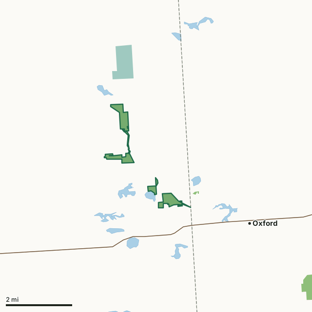
State wildlife areas, forests and other DNR landNational wildlife refuges and waterfowl production areasLand trusts and other open landUpper Neenah Fishery AreaCounty lineLakeHighway
| Size | 384 acres in 6 pieces |
|---|---|
| County | Adams County |
| Deer Management Unit | Adams County |
| DNR lists for hunting | deer, wild turkey, ruffed grouse and woodcock |
| Public access (DNR) | Open to Hiking, Fishing, Hunting and Trapping |
| DNR property page | Upper Neenah Fishery Area |
| Nearest towns | Oxford (2 mi), Grand Marsh (5 mi) and Packwaukee (7 mi) |
What is Upper Neenah Fishery Area like?
The Neenah Creek is a class 1 trout water (self-sustaining trout population, no stocking required) and is designated as an Exceptional Resource Waters (ERW). An ERW is designated for its valuable fisheries resources and wildlife habitat. It provides an exceptional recreational opportunity; however, these waters have some impact from humans in the form of known point source discharges that must maintain specific standards. The land cover is primarily low-lying hardwoods (oak) and swamp hardwoods. The area surrounding the fishery property is comprised mainly of agricultural use, with the major crop being corn.
The Upper Neenah Fishery Area was first created in 1962 and comprises multiple parcels of non-contiguous land totaling over 372 acres. Land purchases continue within the project boundaries to protect the creek and the fishery and provide public access and fishing opportunities. Several in-stream habitat improvement projects have been completed within the fishery area. Upper Neenah Fishery Area is in southeast Adams County in the Towns of New Chester (T 16N, R 7E) and Jackson (T 15N, R 7E). Anglers can expect to shore fish in some places or wade in the stream throughout the fishery area. Some fly fishing opportunities are available, especially in the areas where habitat improvements were made. Brown trout are the dominant species, with a few brook trout to be had.
In the DNR's words, from its page for the property.
What can you hunt on Upper Neenah Fishery Area?
The DNR's page for Upper Neenah Fishery Area names deer, wild turkey, ruffed grouse and woodcock. Each follows Wisconsin's statewide season and, for deer, the tags and rules of the deer management unit.
What are the rules on Upper Neenah Fishery Area?
The DNR's property map lists Upper Neenah Fishery Area as "Open to Hiking, Fishing, Hunting and Trapping". Hunting follows Wisconsin's statewide seasons and the rules posted on the property.
Activities the DNR lists for Upper Neenah Fishery Area: Hunting - grouse, woodcock, turkey and deer, Trapping, Hiking, Pets, Wildlife viewing, Fishing and Bird watching.
How many deer are taken around Upper Neenah Fishery Area?
Upper Neenah Fishery Area lies in Adams County. The DNR registered 6,148 deer in Adams County in 2025, against 6,658 in 2024.
| DMU | Upper Neenah Fishery Area acres in it | Deer, 2025 | Deer, 2024 | Deer, 2023 |
|---|---|---|---|---|
| Adams County | 384 | 6,148 | 6,658 | 5,428 |
Harvest for the whole deer management unit, not the property alone: Wisconsin DNR Deer Metrics (registered harvest by deer management unit).
How do you get to Upper Neenah Fishery Area?
Nearest towns: Oxford (2 miles), Grand Marsh (5 miles), Packwaukee (7 miles) and Easton (8 miles). Highways within 5 miles: WI 82.
What other public land is near Upper Neenah Fishery Area?
DNR properties within 10 miles:
- Lawrence Creek Wildlife Area: 950 acres, 3.9 miles away
- Campbell Creek-White Creek SHA: 26 acres, 6.5 miles away
Public land within 3 miles of Upper Neenah Fishery Area
Counting Upper Neenah Fishery Area itself, 736 of the 36,995 acres within 3 miles of its boundary are public land open to the public (2%), by USGS PAD-US 4.1 (fee land open to the public).
| Manager | Acres within 3 miles |
|---|---|
| State wildlife areas, forests and other DNR land | 394 |
| National wildlife refuges and waterfowl production areas | 342 |
Questions hunters ask
Where is Upper Neenah Fishery Area?
In Adams County, 2 miles from Oxford. The DNR's property page has its maps and parking.
Is Upper Neenah Fishery Area open to hunting?
Yes. The DNR's property map lists it as "Open to Hiking, Fishing, Hunting and Trapping". Posted refuges or closed areas, where there are any, are marked on site.
Which deer management unit is Upper Neenah Fishery Area in?
Adams County.
How much public land is around Upper Neenah Fishery Area?
736 acres within 3 miles of its boundary, Upper Neenah Fishery Area included, by PAD-US 4.1. The closest other DNR property is Lawrence Creek Wildlife Area (3.9 miles).
Get a Wisconsin hunt plan when they open
Hunt plans for Wisconsin are coming. Join the list and you'll hear first. The first 50 hunters in each new state get their plan free.
Until then, the free FilledTag app for iPhone has a map that works in every state, Wisconsin included.
Where these facts come from
- Area description, species, rules and directions: DNR, Upper Neenah Fishery Area; Wisconsin DNR managed lands open to hunting.
- Boundary and acres: the DNR's map layer above. Surrounding public land: USGS PAD-US 4.1 (fee land open to the public).
- Deer harvest: Wisconsin DNR Deer Metrics (registered harvest by deer management unit).
FilledTag is not part of the Wisconsin Department of Natural Resources. Check the DNR's rules and posted signs before you go.