Upper Wolf River Fishery Area: hunting and access
Upper Wolf River Fishery Area is 9,345 acres of land managed by the Wisconsin DNR in Langlade County, next to Elcho. The DNR's page for it names deer, wild turkey, ducks and geese, bear and small game among the game here. Hunters registered 1,726 deer in DMU 123 in 2025.
Data updated October 2026. Area facts: the DNR's DNR property data, read 2026-10. Harvest: DNR Deer Metrics.
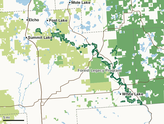
State wildlife areas, forests and other DNR landCounty forestNational forestState parksOther county, city and regional landLand trusts and other open landUpper Wolf River Fishery AreaCounty lineLakeHighway
| Size | 9,345 acres in 100 pieces |
|---|---|
| County | Langlade County |
| Deer Management Unit | DMU 123, DMU Langlade, DMU 126, Menominee Reservation |
| DNR lists for hunting | deer, wild turkey, ducks and geese, bear and small game |
| Public access (DNR) | Open to Hiking, Fishing, Hunting and Trapping |
| DNR property page | Upper Wolf River Fishery Area |
| Nearest towns | Elcho (next to it), Post Lake (next to it) and White Lake (next to it) |
What is Upper Wolf River Fishery Area like?
The Upper Wolf River Fishery Area is comprised of many DNR owned properties along the Wolf River in Langlade County. About 95 percent of the Wolf River watershed is wooded and wild. The Wolf River in Langlade County is classified as an Outstanding Resource Water (ORW). The origin of the Wolf River is Pine Lake in southern Forest County. Flowing south, the Wolf River crosses eight counties before it enters Lake Poygan in Winnebago County. Five principal tributaries join the Wolf River in Langlade County including Swamp Creek, Pickerel Creek, Hunting River, Lily River, and Ninemile Creek. Numerous small streams also contribute water to the Wolf River.
The Wolf River has long been recognized for its unique aesthetically pleasing characteristics. It is a wide, boulder-strewn, natural, undeveloped stream with a rapid gradient in many locations. Fish species inhabiting the Wolf River include brook, brown and rainbow trout, large and smallmouth bass, northern pike, musky, walleye and numerous species of pan fish and forage minnows. Trout are most prevalent from County Highway T downstream to the county line. Smallmouth bass inhabits the entire length of the river in Langlade County. Walleye, northern pike, musky and bass are generally found in the upper portion of the Wolf in the area from Post Lake dam downstream to Lily. The Upper Wolf River has become a major Midwest destination for whitewater sports. Several commercial rental, outfitters, and guide companies offer whitewater rafting on the Wolf River.
In the DNR's words, from its page for the property.
What can you hunt on Upper Wolf River Fishery Area?
The DNR's page for Upper Wolf River Fishery Area names deer, wild turkey, ducks and geese, bear and small game. Each follows Wisconsin's statewide season and, for deer, the tags and rules of the deer management unit.
What are the rules on Upper Wolf River Fishery Area?
The DNR's property map lists Upper Wolf River Fishery Area as "Open to Hiking, Fishing, Hunting and Trapping". Hunting follows Wisconsin's statewide seasons and the rules posted on the property.
Activities the DNR lists for Upper Wolf River Fishery Area: Hunting - deer, bear, turkey, small game, and waterfowl, Trapping, Hiking, Snowmobiling trail, Cross-country skiing, Wildlife viewing and Fishing.
How many deer are taken around Upper Wolf River Fishery Area?
Upper Wolf River Fishery Area lies in 4 deer management units. The DNR registered 1,726 deer in DMU 123 in 2025.
| DMU | Upper Wolf River Fishery Area acres in it | Deer, 2025 |
|---|---|---|
| DMU 123 | 6,139 | 1,726 |
| DMU Langlade | 2,475 | 2,007 |
| DMU 126 | 730 | 3,288 |
| Menominee Reservation | 1 |
Harvest for the whole deer management unit, not the property alone: Wisconsin DNR Deer Metrics (registered harvest by deer management unit).
How do you get to Upper Wolf River Fishery Area?
Nearest towns: Elcho (next to it), Post Lake (next to it), White Lake (next to it) and Summit Lake (3 miles). Highways within 5 miles: WI 55, WI 52, WI 47, US 45 and WI 64.
What other public land is near Upper Wolf River Fishery Area?
DNR properties within 10 miles:
- Forest Legacy Program: 33,075 acres, next to it
- Wolf River State Trail: 524 acres, next to it
- Knoke Spring State Spring Ponds: 21 acres, 0.9 miles away
- Evergreen River Fishery Area: 1,150 acres, 1.1 miles away
- Langlade Rearing Station: 120 acres, 1.3 miles away
Public land within 3 miles of Upper Wolf River Fishery Area
Counting Upper Wolf River Fishery Area itself, 98,907 of the 221,693 acres within 3 miles of its boundary are public land open to the public (44.6%), by USGS PAD-US 4.1 (fee land open to the public).
| Manager | Acres within 3 miles |
|---|---|
| County forest | 48,621 |
| State wildlife areas, forests and other DNR land | 25,990 |
| National forest | 23,914 |
| Land trusts and other open land | 363 |
| State parks | 19 |
Questions hunters ask
Where is Upper Wolf River Fishery Area?
In Langlade County, next to Elcho. The DNR's property page has its maps and parking.
Is Upper Wolf River Fishery Area open to hunting?
Yes. The DNR's property map lists it as "Open to Hiking, Fishing, Hunting and Trapping". Posted refuges or closed areas, where there are any, are marked on site.
Which deer management unit is Upper Wolf River Fishery Area in?
DMU 123 (6,139 acres), DMU Langlade (2,475 acres), DMU 126 (730 acres) and Menominee Reservation (1 acres).
How much public land is around Upper Wolf River Fishery Area?
98,907 acres within 3 miles of its boundary, Upper Wolf River Fishery Area included, by PAD-US 4.1. The closest other DNR property is Forest Legacy Program (next to it).
Get a Wisconsin hunt plan when they open
Hunt plans for Wisconsin are coming. Join the list and you'll hear first. The first 50 hunters in each new state get their plan free.
Until then, the free FilledTag app for iPhone has a map that works in every state, Wisconsin included.
Where these facts come from
- Area description, species, rules and directions: DNR, Upper Wolf River Fishery Area; Wisconsin DNR managed lands open to hunting.
- Boundary and acres: the DNR's map layer above. Surrounding public land: USGS PAD-US 4.1 (fee land open to the public).
- Deer harvest: Wisconsin DNR Deer Metrics (registered harvest by deer management unit).
FilledTag is not part of the Wisconsin Department of Natural Resources. Check the DNR's rules and posted signs before you go.