Van Loon Wildlife Area: hunting and access
Van Loon Wildlife Area is 4,048 acres of land managed by the Wisconsin DNR in La Crosse and Trempealeau counties, 3 miles from Holmen. Hunters registered 4,515 deer in La Crosse County in 2025.
Data updated October 2026. Area facts: the DNR's DNR property data, read 2026-10. Harvest: DNR Deer Metrics.
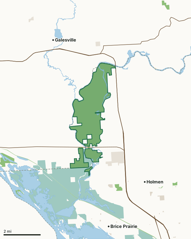
State wildlife areas, forests and other DNR landNational wildlife refuges and waterfowl production areasOther federal landState parksOther county, city and regional landLand trusts and other open landVan Loon Wildlife AreaCounty lineLakeHighway
| Size | 4,048 acres in 4 pieces |
|---|---|
| Counties | La Crosse County and Trempealeau County |
| Deer Management Unit | La Crosse County, Trempealeau County |
| Public access (DNR) | Open to Hiking, Fishing, Hunting and Trapping |
| DNR property page | Van Loon Wildlife Area |
| Nearest towns | Holmen (3 mi), Galesville (3 mi) and Brice Prairie (3 mi) |
What is Van Loon Wildlife Area like?
Van Loon Wildlife Area is a 4,003-acre property located on the Black River in northwestern La Crosse County, approximately 3.5 miles northwest of the Village of Holmen. A small portion of the property in the southwest corner falls into neighboring Trempealeau County. The property encompasses much of the floodplain of the lower Black River for five miles, from “Hunter’s Bridge” on USH 53/STH 93 to CTH XX in New Amsterdam, ending shortly before the Black flows into the Mississippi. The Upper Mississippi River National Wildlife and Fish Refuge is directly to the south. Van Loon Wildlife Area contains two embedded State Natural Areas (SNAs), Van Loon Floodplain Forest and Van Loon Floodplain Savanna, both designated in 2008. Habitat on the property consists primarily of floodplain forest, sand prairies and oak savanna.
Van Loon is a WBCI Important Bird Area noted for yellow-crowned night herons, Acadian flycatchers, cerulean warblers and prothonotary warblers that breed there. The site also supports red-headed woodpeckers, blue-winged warblers and field sparrows. Waterbirds congregate in late summer and thousands of landbirds migrate through, particularly in the spring. Van Loon is also featured in the Mississippi-Chippewa River Region of the Great Wisconsin Birding and Nature Trail. The property also contains six historic McGilvray arch truss bridges over the Black River built circa 1892. McGilvray Road is open to foot traffic and is a popular walking path for viewing the bridges, historic interpretation, wildlife watching, and nature enjoyment. There is one site available for primitive camping on a first-come-first-served basis in the northern part of the property.
In the DNR's words, from its page for the property.
What are the rules on Van Loon Wildlife Area?
The DNR's property map lists Van Loon Wildlife Area as "Open to Hiking, Fishing, Hunting and Trapping". Hunting follows Wisconsin's statewide seasons and the rules posted on the property.
Activities the DNR lists for Van Loon Wildlife Area: Birding;, Camping (primitive);, Canoeing;, Cross-country skiing (no designated trail);, Fishing;, Hiking (no designated trail);, Hunting;, Trapping;, Wild edibles/gathering; and and Wildlife viewing.
How many deer are taken around Van Loon Wildlife Area?
Van Loon Wildlife Area lies in 2 deer management units. The DNR registered 4,515 deer in La Crosse County in 2025, against 4,039 in 2024.
| DMU | Van Loon Wildlife Area acres in it | Deer, 2025 | Deer, 2024 | Deer, 2023 |
|---|---|---|---|---|
| La Crosse County | 3,748 | 4,515 | 4,039 | 4,086 |
| Trempealeau County | 300 | 7,151 | 6,627 | 6,360 |
Harvest for the whole deer management unit, not the property alone: Wisconsin DNR Deer Metrics (registered harvest by deer management unit).
How do you get to Van Loon Wildlife Area?
Nearest towns: Holmen (3 miles), Galesville (3 miles), Brice Prairie (3 miles) and Trempealeau (4 miles). Highways within 5 miles: WI 35, US 53, WI 93 and WI 54.
What other public land is near Van Loon Wildlife Area?
DNR properties within 10 miles:
- Great River State Trail: 255 acres, 1 mile away
- Mississippi Islands Wildlife Area: 59 acres, 2.8 miles away
- Trempealeau Lakes Fishery Area: 169 acres, 2.9 miles away
- La Crosse Area Comprehensive Fishery Area: 2,495 acres, 3.4 miles away
- Hardies Creek Timber Demo Forest: 56 acres, 4.1 miles away
Public land within 3 miles of Van Loon Wildlife Area
Counting Van Loon Wildlife Area itself, 11,100 of the 51,359 acres within 3 miles of its boundary are public land open to the public (21.6%), by USGS PAD-US 4.1 (fee land open to the public).
| Manager | Acres within 3 miles |
|---|---|
| National wildlife refuges and waterfowl production areas | 6,446 |
| State wildlife areas, forests and other DNR land | 4,256 |
| Land trusts and other open land | 354 |
| Other county, city and regional land | 36 |
| State parks | 5 |
| Other federal land | 3 |
Questions hunters ask
Where is Van Loon Wildlife Area?
In La Crosse and Trempealeau counties, 3 miles from Holmen. The DNR's property page has its maps and parking.
Is Van Loon Wildlife Area open to hunting?
Yes. The DNR's property map lists it as "Open to Hiking, Fishing, Hunting and Trapping". Posted refuges or closed areas, where there are any, are marked on site.
Which deer management unit is Van Loon Wildlife Area in?
La Crosse County (3,748 acres) and Trempealeau County (300 acres).
How much public land is around Van Loon Wildlife Area?
11,100 acres within 3 miles of its boundary, Van Loon Wildlife Area included, by PAD-US 4.1. The closest other DNR property is Great River State Trail (1 mile).
Get a Wisconsin hunt plan when they open
Hunt plans for Wisconsin are coming. Join the list and you'll hear first. The first 50 hunters in each new state get their plan free.
Until then, the free FilledTag app for iPhone has a map that works in every state, Wisconsin included.
Where these facts come from
- Area description, species, rules and directions: DNR, Van Loon Wildlife Area; Wisconsin DNR managed lands open to hunting.
- Boundary and acres: the DNR's map layer above. Surrounding public land: USGS PAD-US 4.1 (fee land open to the public).
- Deer harvest: Wisconsin DNR Deer Metrics (registered harvest by deer management unit).
FilledTag is not part of the Wisconsin Department of Natural Resources. Check the DNR's rules and posted signs before you go.
Wisconsin hunting La Crosse County Trempealeau County La Crosse County Trempealeau County