White River Marsh Wildlife Area: hunting and access
White River Marsh Wildlife Area is 12,706 acres of land managed by the Wisconsin DNR in Green Lake, Marquette and Waushara counties, next to Neshkoro. The DNR's page for it names deer, pheasants, ducks and geese, woodcock and small game among the game here. Hunters registered 4,589 deer in Green Lake County in 2025.
Data updated October 2026. Area facts: the DNR's DNR property data, read 2026-10. Harvest: DNR Deer Metrics.
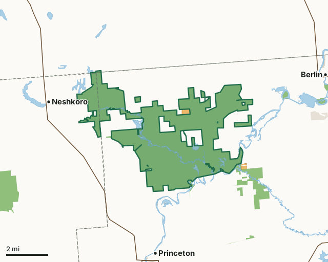
State wildlife areas, forests and other DNR landOther county, city and regional landLand trusts and other open landVoluntary Public Access landWhite River Marsh Wildlife AreaCounty lineLakeHighway
| Size | 12,706 acres in 6 pieces |
|---|---|
| Counties | Green Lake County, Marquette County and Waushara County |
| Deer Management Unit | Green Lake County, Marquette County, Waushara County |
| DNR lists for hunting | deer, pheasants, ducks and geese, woodcock and small game |
| Public access (DNR) | Open to Hiking, Fishing, Hunting and Trapping |
| DNR property page | White River Marsh Wildlife Area |
| Nearest towns | Neshkoro (next to it), Princeton (3 mi) and Berlin (4 mi) |
What is White River Marsh Wildlife Area like?
White River Marsh Wildlife Area is a 12,000-acre property in the northwest corner of Green Lake County and the northeast corner of Marquette County. Find it approximately 6 miles north of the city of Princeton on County Highway D, or approximately 3 miles west of the city of Berlin on County Highway F. The property consists of open marsh/wet meadow, swamp hardwoods/tamarack swamp, upland prairie/oak savanna and shrub carr. This property offers various outdoor recreational opportunities. Small game, waterfowl, deer and pheasant are among the most popular game that hunters pursue. All of these species are abundant throughout the wildlife area. Additional user groups visit the property to hike, gather edible plants, wildlife views and canoe/kayak.
The Wisconsin Conservation Commission approved the preliminary project and first land acquisition on the White River Marsh on March 30, 1962. Aldo Leopold had investigated the marsh in the 1940s and recommended federal or state purchase of the marsh for conservation purposes. Prairie chickens and bobwhite quail were abundant on the marsh. Much of the uplands were farmed for row or small grain crops and most of the wetlands were drained or altered for farming. The marsh grass (sedge, bluejoint and prairie cordgrass) was used for cattle feed, bedding and the production of carpet fiber at factories in Oshkosh. The marshes were cut by horse-drawn equipment and shipped to Oshkosh via the lock and dam system on the Fox River.
In the DNR's words, from its page for the property.
What can you hunt on White River Marsh Wildlife Area?
The DNR's page for White River Marsh Wildlife Area names deer, pheasants, ducks and geese, woodcock and small game. Each follows Wisconsin's statewide season and, for deer, the tags and rules of the deer management unit.
What are the rules on White River Marsh Wildlife Area?
The DNR's property map lists White River Marsh Wildlife Area as "Open to Hiking, Fishing, Hunting and Trapping". Hunting follows Wisconsin's statewide seasons and the rules posted on the property.
Activities the DNR lists for White River Marsh Wildlife Area: Auto travel (a Rustic Road bisects much of the wildlife area that provides an excellent wildlife viewing opportunity), Biking (town road only), Birding, Canoeing, Cross-country skiing (no designated trail), Fishing, Hiking (no designated trail), Hunting (noted for pheasant *, small game, waterfowl, deer, mourning dove and woodcock), Kayaking, Trapping, Wild edibles/gathering and Wildlife viewing.
How many deer are taken around White River Marsh Wildlife Area?
White River Marsh Wildlife Area lies in 3 deer management units. The DNR registered 4,589 deer in Green Lake County in 2025, against 4,428 in 2024.
| DMU | White River Marsh Wildlife Area acres in it | Deer, 2025 | Deer, 2024 | Deer, 2023 |
|---|---|---|---|---|
| Green Lake County | 11,843 | 4,589 | 4,428 | 4,081 |
| Marquette County | 853 | 7,790 | 7,744 | 6,550 |
| Waushara County | 9 | 8,678 | 8,191 | 6,404 |
Harvest for the whole deer management unit, not the property alone: Wisconsin DNR Deer Metrics (registered harvest by deer management unit).
How do you get to White River Marsh Wildlife Area?
Nearest towns: Neshkoro (next to it), Princeton (3 miles), Berlin (4 miles) and Lohrville (4 miles). Highways within 5 miles: WI 73, WI 49, WI 23, WI 21 and WI 91. 2 VPA properties within 3 miles.
What other public land is near White River Marsh Wildlife Area?
DNR properties within 10 miles:
- Upper Fox River Public Access: 401 acres, next to it
- Princeton Prairie State Natural Area: 132 acres, next to it
- Puchyan Prairie State Natural Area: 382 acres, 1 mile away
- Snake Creek Fen State Natural Area: 30 acres, 3.1 miles away
- Germania Wildlife Area: 2,416 acres, 3.9 miles away
- Willow Creek Fishery Area: 2,864 acres, 4.6 miles away
Public land within 3 miles of White River Marsh Wildlife Area
Counting White River Marsh Wildlife Area itself, 13,768 of the 83,130 acres within 3 miles of its boundary are public land open to the public (16.6%), by USGS PAD-US 4.1 (fee land open to the public).
| Manager | Acres within 3 miles |
|---|---|
| State wildlife areas, forests and other DNR land | 13,716 |
| Land trusts and other open land | 52 |
Questions hunters ask
Where is White River Marsh Wildlife Area?
In Green Lake, Marquette and Waushara counties, next to Neshkoro. The DNR's property page has its maps and parking.
Is White River Marsh Wildlife Area open to hunting?
Yes. The DNR's property map lists it as "Open to Hiking, Fishing, Hunting and Trapping". Posted refuges or closed areas, where there are any, are marked on site.
Which deer management unit is White River Marsh Wildlife Area in?
Green Lake County (11,843 acres), Marquette County (853 acres) and Waushara County (9 acres).
How much public land is around White River Marsh Wildlife Area?
13,768 acres within 3 miles of its boundary, White River Marsh Wildlife Area included, by PAD-US 4.1. The closest other DNR property is Upper Fox River Public Access (next to it).
Get a Wisconsin hunt plan when they open
Hunt plans for Wisconsin are coming. Join the list and you'll hear first. The first 50 hunters in each new state get their plan free.
Until then, the free FilledTag app for iPhone has a map that works in every state, Wisconsin included.
Where these facts come from
- Area description, species, rules and directions: DNR, White River Marsh Wildlife Area; Wisconsin DNR managed lands open to hunting.
- Boundary and acres: the DNR's map layer above. Surrounding public land: USGS PAD-US 4.1 (fee land open to the public).
- Deer harvest: Wisconsin DNR Deer Metrics (registered harvest by deer management unit).
FilledTag is not part of the Wisconsin Department of Natural Resources. Check the DNR's rules and posted signs before you go.
Wisconsin hunting Green Lake County Marquette County Waushara County Green Lake County Marquette County Waushara County