Unit 19A pronghorn hunting: 2026 hunts, harvest and draw
AZGFD's 2026 Pronghorn and Elk booklet lists 3 pronghorn hunts open in Unit 19A, with 32 permits in all. The largest is hunt 2023, buck pronghorn, September 4 to September 10, with 20 permits. On the 3 hunts held only in Unit 19A in 2025, AZGFD's harvest survey counts 31 hunters and 26 pronghorn taken.
Data updated October 2026. Hunts: AZGFD's 2026 Pronghorn and Elk booklet. Harvest: AZGFD harvest summaries, 2021 to 2025. Draw: AZGFD's 2025 report.
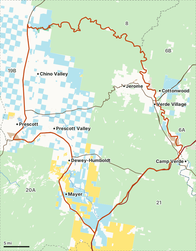
National forestBLMState trust landAZGFD landNational park or monument (no hunting)Tribal land (tribal permit)City, county and otherUnit 19ANeighboring unitsLake or riverHighway
| Unit | Unit 19A |
|---|---|
| AZGFD region | Region 3, Kingman |
| Pronghorn hunts, 2026 | 3 (32 permits) |
| Hunt types | general, muzzleloader and archery only |
| Earliest season | August 21 to August 27 (hunt 2056) |
| Pronghorn taken on its own hunts, 2025 | 26 by 31 hunters |
| 2025 draw, first-choice applicants | 2,389 for 35 permits issued |
| Public land open to hunting | 69.2%, mostly national forest |
What pronghorn hunts does Unit 19A have in 2026?
3 hunts: 1 general, 1 muzzleloader and 1 archery only. 3 are held only in Unit 19A. Permits are AZGFD's numbers for the whole hunt.
| Hunt | Type | Season, 2026 | Legal animal | Permits | Open area |
|---|---|---|---|---|---|
| 2023 | General | Sep 4 to Sep 10 | Buck pronghorn | 20 | 19A (north of AZ Hwy 89A and that portion south of AZ Hwy 89A that is east of Fain Rd, north of AZ Hwy 69/169, and west of FR 151/643) |
| 2036 | Muzzleloader | Aug 28 to Sep 3 | Buck pronghorn | 5 | 19A (north of AZ Hwy 89A and that portion south of AZ Hwy 89A that is east of Fain Rd, north of AZ Hwy 69/169, and west of FR 151/643) |
| 2056 | Archery only | Aug 21 to Aug 27 | Buck pronghorn | 7 | 19A (north of AZ Hwy 89A and the portion south of AZ Hwy 89A that is east of Robert Road, north of AZ Hwy 69/169, and west of FR 151/643) |
Source: AZGFD 2026 Pronghorn and Elk Hunt Draw Information, PDF page 13. Note numbers refer to AZGFD's printed notes, which set boundaries and restrictions; read them before you apply.
How many pronghorn are harvested in Unit 19A?
Year by year, the hunts held only in Unit 19A. Hunter and harvest totals are sums of AZGFD's figures for those hunts.
| Year | Hunts | Hunters | Hunter days | Pronghorn taken | Pronghorn per 100 hunters |
|---|---|---|---|---|---|
| 2025 | 3 | 31 | 74 | 26 | 84 |
| 2024 | 3 | 33 | 61 | 29 | 88 |
| 2023 | 3 | 31 | 60 | 27 | 87 |
| 2022 | 4 | 46 | 118 | 38 | 83 |
| 2021 | 4 | 44 | 132 | 33 | 75 |
Pronghorn per 100 hunters is worked out from AZGFD's own hunter and harvest figures for the same hunts.
Every hunt that included Unit 19A, as AZGFD reported it:
| Hunt | Type | Area | Permits issued | Hunters | Hunter days | Harvest | Success (AZGFD) |
|---|---|---|---|---|---|---|---|
| 2022 | General | 19A | 20 | 18 | 37 | 17 | 94% |
| 2056 | Archery only | 19A | 9 | 9 | 32 | 5 | 56% |
| 2036 | Muzzleloader | 19A | 4 | 4 | 5 | 4 | 100% |
| Hunt | Type | Area | Permits issued | Hunters | Hunter days | Harvest | Success (AZGFD) |
|---|---|---|---|---|---|---|---|
| 2021 | General | 19A | 19 | 18 | 26 | 16 | 89% |
| 2054 | Archery only | 19A | 10 | 10 | 30 | 8 | 80% |
| 2034 | Muzzleloader | 19A | 5 | 5 | 5 | 5 | 100% |
Earlier years: 2023, 2022, 2021
| Hunt | Type | Area | Permits issued | Hunters | Hunter days | Harvest | Success (AZGFD) |
|---|---|---|---|---|---|---|---|
| 2021 | General | 19A | 19 | 19 | 30 | 17 | 89% |
| 2053 | Archery only | 19A | 9 | 7 | 22 | 5 | 71% |
| 2033 | Muzzleloader | 19A | 5 | 5 | 8 | 5 | 100% |
| Hunt | Type | Area | Permits issued | Hunters | Hunter days | Harvest | Success (AZGFD) |
|---|---|---|---|---|---|---|---|
| 2021 | General | 19A | 15 | 15 | 20 | 15 | 100% |
| 2022 | General | 19A | 15 | 15 | 26 | 15 | 100% |
| 2055 | Archery only | 19A | 14 | 12 | 49 | 7 | 58% |
| 2034 | Muzzleloader | 19A | 4 | 4 | 23 | 1 | 25% |
| Hunt | Type | Area | Permits issued | Hunters | Hunter days | Harvest | Success (AZGFD) |
|---|---|---|---|---|---|---|---|
| 2021 | General | 19A | 17 | 14 | 30 | 12 | 82% |
| 2034 | Muzzleloader | 19A | 8 | 8 | 23 | 7 | 86% |
| 2054 | General | 19A | 12 | 9 | 36 | 4 | 50% |
| 2055 | General | 19A | 13 | 13 | 43 | 10 | 78% |
Source: AZGFD 2025 Pronghorn Harvest Summary, AZGFD 2024 Pronghorn Harvest Summary, AZGFD 2023 Pronghorn Harvest Summary, AZGFD 2022 Pronghorn Harvest Summary, AZGFD 2021 Pronghorn Harvest Summary. Success is AZGFD's printed figure, and AZGFD's parts (bulls, cows, species) do not always add up to its harvest total; both are shown as printed. Hunt numbers change from year to year; the area column says where each hunt was. Rows AZGFD printed with a blank middle cell are left out rather than guessed.
How many hunters applied in the 2025 draw?
AZGFD's 2025 draw report lists 3 pronghorn hunts that included Unit 19A: 2,389 first-choice applications for 35 permits issued. These are 2025 counts, not a forecast.
| Hunt, 2025 | Area | Hunt type | Season | First-choice applicants | Second-choice applicants | Permits issued |
|---|---|---|---|---|---|---|
| 2022 | 19A | Buck pronghorn | 9/5 to 9/11 | 1,826 | 1,459 | 20 |
| 2036 | 19A | Buck pronghorn | 8/29 to 9/4 | 302 | 336 | 5 |
| 2056 | 19A | Buck pronghorn | 8/22 to 8/28 | 261 | 289 | 10 |
Source: AZGFD 2025 Pronghorn draw report. AZGFD's report also prints a percentage column whose basis it does not state, so it is not copied here.
What did AZGFD's 2025 survey count?
In Unit 19A, AZGFD's 2025 pronghorn survey classified 439 animals in 48 groups: 26 bucks and 13 young per 100 does.
Source: AZGFD 2025 Pronghorn Survey Summary.
How much public land is in Unit 19A?
69.2% of Unit 19A is public land open to hunting: 335,100 of 484,006 acres, the largest share national forest (243,677 acres). The Unit 19A page has the full land table, towns and roads.
Measured by FilledTag inside AZGFD's unit boundaries from USGS PAD-US 4.1 (fee managers). Public land open to hunting here means national forest, BLM, state trust land, AZGFD land, national wildlife refuges, national recreation areas and Bureau of Reclamation land. Tribal land, military land and national parks are counted on their own rows and left out of that figure.
Questions hunters ask
How many pronghorn permits does Unit 19A have in 2026?
32 permits across 3 hunts in AZGFD's 2026 booklet. The largest is hunt 2023 (buck pronghorn).
When is pronghorn season in Unit 19A in 2026?
The first pronghorn hunt open here starts August 21 (hunt 2056, archery only) and the last ends September 10. Each hunt's dates are in the table on this page.
How many pronghorn were harvested in Unit 19A in 2025?
AZGFD's 2025 harvest survey counts 26 pronghorn taken by 31 hunters on the 3 hunts held only in Unit 19A, against 29 in 2024. Hunts shared with other units are counted in AZGFD's table for each hunt, not added here.
How many hunters applied for Unit 19A pronghorn in 2025?
AZGFD's 2025 draw report counts 2,389 first-choice applications for the 3 pronghorn hunts that included Unit 19A, and 35 permits issued. AZGFD publishes no forecast for 2026; these are 2025 counts.
Get Arizona updates from FilledTag
Join the Arizona list and FilledTag will email you when it adds more for Arizona hunters.
The free FilledTag app for iPhone has a map that works in every state, Arizona included.
Where these numbers come from
- Hunts, seasons, legal animals and permits: AZGFD 2026 Pronghorn and Elk Hunt Draw Information.
- Harvest, hunters and days: AZGFD 2025 Pronghorn Harvest Summary, AZGFD 2024 Pronghorn Harvest Summary, AZGFD 2023 Pronghorn Harvest Summary, AZGFD 2022 Pronghorn Harvest Summary, AZGFD 2021 Pronghorn Harvest Summary.
- Draw applicants and permits: AZGFD 2025 Pronghorn draw report.
- Unit boundaries: AZGFD game management unit boundaries. Public land: USGS PAD-US 4.1 (fee managers).
FilledTag is not part of the Arizona Game and Fish Department. Numbers are copied from AZGFD's published reports or measured from AZGFD and USGS maps; nothing here is estimated by FilledTag. AZGFD's regulations are the final word on every rule.