Dave Donaldson Black River WMA: deer harvest, 2026-27 seasons and map
Dave Donaldson Black River WMA is 25,482 acres of public hunting land in Clay, Randolph and Greene counties, AGFC's WMA zone 170. Hunters checked 62 deer on it in the 2024-25 season, 37 antlered bucks among them (AGFC's deer check records). AGFC's 2026-27 dates for the area: Deer Archery, Aug. 29-31 (one antlered buck only); Sept. 26-Feb. 28.
Data updated October 2026. Seasons and area rules: AGFC's page for the area. Harvest: AGFC's deer check records, 2022-23 to 2024-25.
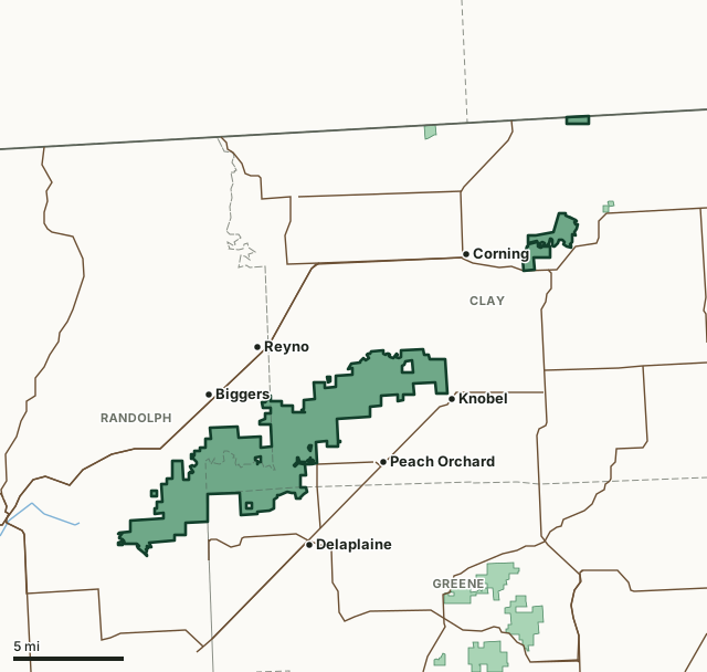
Dave Donaldson Black River WMAOther AGFC WMAsNational wildlife refugeLake or riverHighwayCounty line
| Size | 25,482 acres (AGFC) |
|---|---|
| County | Clay County, Randolph County, Greene County |
| AGFC WMA zone | 170 |
| Deer zone around it | Zone 4 |
| Area rules | Mobility-Impaired Access, Flood Prone Region, Waterfowl Season Access Restrictions, 15-Inch Inside Spread or 18-Inch Main Beam Rule and Valid Hunting or Fishing License or a WMA/Lake Conservation Permit is Required for All Users |
| Deer checked, 2024-25 | 62 (37 antlered bucks, 0 button bucks, 25 does) |
| Phone | 833-200-5199 |
| Nearest towns | Knobel (next to it), Biggers (next to it) and Delaplaine (2 mi) |
When are the 2026-27 seasons on Dave Donaldson Black River WMA?
AGFC sets each WMA's own dates and limits. These are its big game seasons for the area.
2026-27 Closed Seasons
- Deer alternative firearms
- Bear
- Alligator
2026-27 Deer
- Deer Archery: Aug. 29-31 (one antlered buck only); Sept. 26-Feb. 28.
- Deer Modern Gun (permit required): Nov. 14-18.
- Deer Modern Gun Youth Hunt (permit required): Nov. 7-8 and Jan. 2-3.
- WMA Deer Bag Limit: Three deer, no more than two antlered bucks (15/18 Rule applies), which may include:
- Two antlered bucks with archery,
- Three antlerless deer with archery,
- One antlered buck and one antlerless deer with modern gun permit,
- During youth hunt, youths may take two deer, one antlered buck (no antler restrictions) and one antlerless deer.
2027 Turkey
- Turkey Youth Hunt: April 10-11. One legal turkey.
- Firearms Hunt: April 19-27. One legal turkey.
Other seasons AGFC lists for the area: crow, dove, quail, rabbit, squirrel and waterfowl. Their dates are on AGFC's page.
Source: AGFC, Dave Donaldson Black River WMA, read October 2026. AGFC's page and its regulations are the final word.
How many deer are taken on Dave Donaldson Black River WMA?
Hunters checked 62 deer on Dave Donaldson Black River WMA in the 2024-25 season. Over the 3 seasons in AGFC's records, the area averaged 79 deer a season.
| Season | Deer checked | Antlered bucks | Button bucks | Does |
|---|---|---|---|---|
| 2024-25 | 62 | 37 | 0 | 25 |
| 2023-24 | 80 | 45 | 2 | 33 |
| 2022-23 | 96 | 53 | 4 | 39 |
Source: AGFC deer check records, 2022-23 to 2024-25, counted by FilledTag from the records AGFC files under this WMA.
What should you know before hunting Dave Donaldson Black River WMA?
Location
The area is 10 miles south of Corning, 10 miles east of Pocahontas, 20 miles west of Paragould and 15 miles north of Walnut Ridge.
Area Notes
Free georeferenced maps are available for this WMA and others at https://apps.agfc.com/maps/. These maps are frequently updated and include features such as parking, types of road and land boundaries.
The Winchester WRA and Brookings moist-soil units are closed to access Nov. 1-Feb. 15 except during Deer Modern Gun Permit and Youth Hunts.
Lake Ashbaugh and Hubble Lake are closed to all hunting except early teal season (Sept. 19-27).
Slough boats may be left overnight at select location during duck season.
Camping
Although there is little interest in overnight camping on Black River, camping is permitted in designated campsites. These are marked on area maps that are available at the area headquarters, or from commission employees and regional commission offices. These are primitive areas and no modern facilities are available. Mosquitoes, biting flies and poison ivy are extremely common and campers should be prepared for them.
Description
Hardwood forests comprise several tree species. The dominant species are nuttall oak, overcup oak, pin oak and water oak. Bald cypress, tupelo and willow may be found along the sloughs that form a network of waterways on the area. The major streams are Black River and Little River.
Ownership
The AGFC owns about 25,000 acres in Clay, Randolph and Green counties.
Age
Acquisition began in 1957.
From AGFC's page for the area.
Which county is Dave Donaldson Black River WMA in?
| County | Acres of the area in it | County deer, 2024-25 | Rank of 75 |
|---|---|---|---|
| Clay County | 16,610 | 1,148 | 67th |
| Randolph County | 7,714 | 2,775 | 33rd |
| Greene County | 1,218 | 1,825 | 56th |
Acres measured by FilledTag on AGFC WMA boundaries and the U.S. Census Bureau 2024 county boundaries. County harvest: AGFC deer check records, 2022-23 to 2024-25.
How do you get to Dave Donaldson Black River WMA?
Highways within 5 miles: US 62, US 67, AR 90 and AR 34. Nearest towns: Knobel (next to it), Biggers (next to it), Delaplaine (2 miles) and Peach Orchard (2 miles).
The closest other WMAs with a page here: W. E. Brewer Scatter Creek WMA (7.7 miles) and Robert L. Hankins Mud Creek WMA (12 miles).
Questions hunters ask
When is deer season on Dave Donaldson Black River WMA in 2026-27?
AGFC's dates for Dave Donaldson Black River WMA: Deer Archery, Aug. 29-31 (one antlered buck only); Sept. 26-Feb. 28. Deer Modern Gun (permit required), Nov. 14-18. Deer Modern Gun Youth Hunt (permit required), Nov. 7-8 and Jan. 2-3.
How many deer can you take on Dave Donaldson Black River WMA?
Three deer, no more than two antlered bucks (15/18 Rule applies), which may include: two antlered bucks with archery, three antlerless deer with archery, one antlered buck and one antlerless deer with modern gun permit and during youth hunt, youths may take two deer, one antlered buck (no antler restrictions) and one antlerless deer. (AGFC's 2026-27 rules for the area).
How many deer were killed on Dave Donaldson Black River WMA last season?
Hunters checked 62 deer on Dave Donaldson Black River WMA in the 2024-25 season: 37 antlered bucks, 0 button bucks and 25 does, by AGFC's deer check records. The 3-season average is 79.
What county is Dave Donaldson Black River WMA in?
Clay County (16,610 acres), Randolph County (7,714 acres) and Greene County (1,218 acres), measured on AGFC's boundary.
Get a Arkansas hunt plan when they open
Hunt plans for Arkansas are coming. Join the list and you'll hear first. The first 50 hunters in each new state get their plan free.
Until then, the free FilledTag app for iPhone has a map that works in every state, Arkansas included.
Where these numbers come from
- Seasons, limits, size and area notes: AGFC's page for each WMA (AGFC Wildlife Management Areas).
- Deer harvest on the area and by county: AGFC deer check records, 2022-23 to 2024-25.
- Boundary: AGFC WMA boundaries. Counties, highways and towns: U.S. Census Bureau 2024 county boundaries; U.S. Census Bureau TIGER/Line 2024 roads; U.S. Census Bureau 2024 Gazetteer. Refuges: U.S. Fish and Wildlife Service refuge boundaries.
FilledTag is not part of the Arkansas Game and Fish Commission. Numbers are copied from AGFC or measured from public maps; nothing on this page is estimated by FilledTag.
Arkansas hunting All Arkansas WMAs Clay County deer harvest Randolph County deer harvest Greene County deer harvest