Maumelle River WMA: deer harvest, 2026-27 seasons and map
Maumelle River WMA is 8,208 acres of public hunting land in Pulaski County, AGFC's WMA zone 425. Hunters checked 21 deer on it in the 2024-25 season, 9 antlered bucks among them (AGFC's deer check records). AGFC's 2026-27 dates for the area: Deer Archery, Aug. 29-31 (one antlered buck only); Sept. 26-Feb. 28.
Data updated October 2026. Seasons and area rules: AGFC's page for the area. Harvest: AGFC's deer check records, 2022-23 to 2024-25.
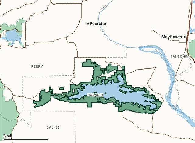
Maumelle River WMAOther AGFC WMAsLake or riverHighwayCounty line
| Size | 8,208 acres (AGFC) |
|---|---|
| County | Pulaski County |
| AGFC WMA zone | 425 |
| Deer zone around it | Zone 10, Zone 13 |
| Area rules | Three-point rule and Special Firearms Restrictions |
| Deer checked, 2024-25 | 21 (9 antlered bucks, 0 button bucks, 12 does) |
| Phone | 833-356-0933 |
| Nearest towns | Fourche (4 mi), Maumelle (4 mi) and Bigelow (4 mi) |
When are the 2026-27 seasons on Maumelle River WMA?
AGFC sets each WMA's own dates and limits. These are its big game seasons for the area.
2026-27 Closed Seasons
- Deer firearms
- Bear firearms
- Furbearer trapping
- Alligator
2026-27 Deer
- Deer Archery: Aug. 29-31 (one antlered buck only); Sept. 26-Feb. 28.
- WMA Deer Bag Limit: Three deer, no more than two antlered bucks (3-Point Rule applies), which may include:
- Two antlered bucks with archery,
- Three antlerless deer with archery.
2026 Bear
- Bear Archery: Sept. 9-Nov. 30.
2027 Turkey
- Turkey Youth Hunt (permit required): April 10-11. One legal turkey.
- Turkey Firearms (permit required): April 19-21, April 24-26, May 1-3 and May 7-9. One legal turkey.
Other seasons AGFC lists for the area: crow, quail, rabbit and squirrel. Their dates are on AGFC's page.
Source: AGFC, Maumelle River WMA, read October 2026. AGFC's page and its regulations are the final word.
How many deer are taken on Maumelle River WMA?
Hunters checked 21 deer on Maumelle River WMA in the 2024-25 season. Over the 3 seasons in AGFC's records, the area averaged 14 deer a season.
| Season | Deer checked | Antlered bucks | Button bucks | Does |
|---|---|---|---|---|
| 2024-25 | 21 | 9 | 0 | 12 |
| 2023-24 | 12 | 5 | 2 | 5 |
| 2022-23 | 10 | 5 | 1 | 4 |
Source: AGFC deer check records, 2022-23 to 2024-25, counted by FilledTag from the records AGFC files under this WMA.
What should you know before hunting Maumelle River WMA?
Area Notes
Free georeferenced maps are available for this WMA and others at https://apps.agfc.com/maps/. These maps are frequently updated and include features such as parking, types of road and land boundaries.
Camping is prohibited.
Horses and mules are prohibited without a special permit from Central Arkansas Water.
Shotguns using legal, non-toxic ammunition are required to take small game, turkey and furbearers.
Additional land use maps available at https://carkw.com/lake-maumelle/.
Ownership
Central Arkansas Waterworks
From AGFC's page for the area.
Which county is Maumelle River WMA in?
| County | Acres of the area in it | County deer, 2024-25 | Rank of 75 |
|---|---|---|---|
| Pulaski County | 12,511 | 2,761 | 35th |
Acres measured by FilledTag on AGFC WMA boundaries and the U.S. Census Bureau 2024 county boundaries. County harvest: AGFC deer check records, 2022-23 to 2024-25.
How do you get to Maumelle River WMA?
Highways through the area: AR 10, AR 113 and AR 300. Nearest towns: Fourche (4 miles), Maumelle (4 miles), Bigelow (4 miles) and Mayflower (7 miles).
The closest other WMAs with a page here: Winona WMA (1.8 miles), Harris Brake WMA (5.3 miles), Bell Slough WMA (5.6 miles) and Camp Robinson WMA (6.4 miles).
Questions hunters ask
When is deer season on Maumelle River WMA in 2026-27?
AGFC's dates for Maumelle River WMA: Deer Archery, Aug. 29-31 (one antlered buck only); Sept. 26-Feb. 28.
How many deer can you take on Maumelle River WMA?
Three deer, no more than two antlered bucks (3-Point Rule applies), which may include: two antlered bucks with archery and three antlerless deer with archery. (AGFC's 2026-27 rules for the area).
How many deer were killed on Maumelle River WMA last season?
Hunters checked 21 deer on Maumelle River WMA in the 2024-25 season: 9 antlered bucks, 0 button bucks and 12 does, by AGFC's deer check records. The 3-season average is 14.
What county is Maumelle River WMA in?
All of it is in Pulaski County, by AGFC's boundary.
Get a Arkansas hunt plan when they open
Hunt plans for Arkansas are coming. Join the list and you'll hear first. The first 50 hunters in each new state get their plan free.
Until then, the free FilledTag app for iPhone has a map that works in every state, Arkansas included.
Where these numbers come from
- Seasons, limits, size and area notes: AGFC's page for each WMA (AGFC Wildlife Management Areas).
- Deer harvest on the area and by county: AGFC deer check records, 2022-23 to 2024-25.
- Boundary: AGFC WMA boundaries. Counties, highways and towns: U.S. Census Bureau 2024 county boundaries; U.S. Census Bureau TIGER/Line 2024 roads; U.S. Census Bureau 2024 Gazetteer. Refuges: U.S. Fish and Wildlife Service refuge boundaries.
FilledTag is not part of the Arkansas Game and Fish Commission. Numbers are copied from AGFC or measured from public maps; nothing on this page is estimated by FilledTag.
Arkansas hunting All Arkansas WMAs Pulaski County deer harvest