St. Francis National Forest WMA: deer harvest, 2026-27 seasons and map
St. Francis National Forest WMA is 22,798 acres of public hunting land in Lee and Phillips counties, AGFC's WMA zone 590. Hunters checked 84 deer on it in the 2024-25 season, 56 antlered bucks among them (AGFC's deer check records). AGFC's 2026-27 dates for the area: Deer Archery, Aug. 29-31 (one antlered buck only); Sept. 26-Feb. 28.
Data updated October 2026. Seasons and area rules: AGFC's page for the area. Harvest: AGFC's deer check records, 2022-23 to 2024-25.
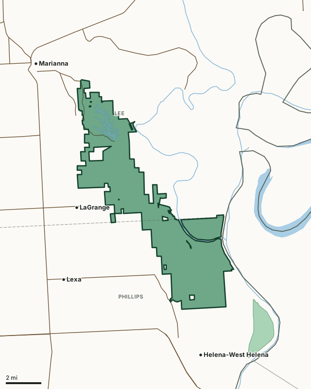
St. Francis National Forest WMAOther AGFC WMAsLake or riverHighwayCounty line
| Size | 22,798 acres (AGFC) |
|---|---|
| County | Lee County, Phillips County |
| AGFC WMA zone | 590 |
| Deer zone around it | Zone 4A, Zone 5A, Zone 17 |
| Area rules | 15-Inch Inside Spread or 18-Inch Main Beam Rule and Additional USDA Forest Service Regulations |
| Deer checked, 2024-25 | 84 (56 antlered bucks, 2 button bucks, 26 does) |
| Phone | 833-345-0283 |
| Nearest towns | LaGrange (next to it), Helena-West Helena (3 mi) and Marianna (3 mi) |
When are the 2026-27 seasons on St. Francis National Forest WMA?
AGFC sets each WMA's own dates and limits. These are its big game seasons for the area.
2026-27 Closed Seasons
- Bear
- Alligator
2026-27 Deer
- Deer Archery: Aug. 29-31 (one antlered buck only); Sept. 26-Feb. 28.
- Deer Alternative Firearms (permit required): Oct. 17-21.
- Deer Modern Gun (permit required): Nov. 14-18.
- Deer Modern Gun Youth Hunts: Nov. 7-8 and Jan. 2-3.
- WMA Deer Bag Limit: Three deer, no more than two antlered bucks (15/18 Rule applies), which may include:
- Two antlered bucks with archery,
- Three antlerless deer with archery,
- One antlered buck or one antlerless deer with alternative firearms permit,
- One antlered buck or one antlerless deer with modern gun permit,
- During youth hunt, youths may take two deer, one antlered buck (no antler restrictions) and one antlerless deer.
2027 Turkey
- Youth Hunt: April 10-11. One legal turkey.
- Firearms Hunt: April 19-27. One legal turkey.
Other seasons AGFC lists for the area: crow, quail, rabbit, squirrel and waterfowl. Their dates are on AGFC's page.
Source: AGFC, St. Francis National Forest WMA, read October 2026. AGFC's page and its regulations are the final word.
How many deer are taken on St. Francis National Forest WMA?
Hunters checked 84 deer on St. Francis National Forest WMA in the 2024-25 season. Over the 3 seasons in AGFC's records, the area averaged 76 deer a season.
| Season | Deer checked | Antlered bucks | Button bucks | Does |
|---|---|---|---|---|
| 2024-25 | 84 | 56 | 2 | 26 |
| 2023-24 | 68 | 36 | 5 | 27 |
| 2022-23 | 76 | 43 | 5 | 28 |
Source: AGFC deer check records, 2022-23 to 2024-25, counted by FilledTag from the records AGFC files under this WMA.
What should you know before hunting St. Francis National Forest WMA?
Location
The forest, comprising 20,946 acres, is in east central Arkansas in Lee and Phillips counties, between the towns of Marianna and Helena-West Helena. State highway 44 bisects the forest. It is bounded on the east and south by the LêAnguille, St. Francis and Mississippi Rivers, Wire Road on the west and Jeffersonville Road on the North. It is situated 50 miles southwest of Memphis, TN and 20 miles south of Forest City.
Area Notes
Free georeferenced maps are available for this WMA and others at https://apps.agfc.com/maps/. These maps are frequently updated and include features such as parking, types of road and land boundaries.
No hunting allowed within signed boundaries of Mississippi River State Park.
Boat motors over 10 horsepower are not allowed.
Camping
Camping areas are located around Bear Creek and Storm Creek lakes. The U.S. Forest Service maintains them on a fee basis. These campsites are semi-private, meaning there are restrooms, tent pads, trailer areas, grills, picnic tables and water sources. No electricity is available at Storm Creek Lake campsites, but 14 sites at Beech Point Campground on Bear Creek Lake have electricity, seweage and water hookups.
Description
It consists of upland hardwood forests located on the hilly Crowley’s Ridge section, with approximately 2500 acres of bottomland timber adjacent to the St. Francis and Mississippi Rivers. The St. Francis has two man made lakes, Bear Creek and Storm Creek, established in 1938 and opened for fishing in 1940 and 1942 respectively. Both lakes were initially stocked with bass, bream and crappie and are cooperatively managed by the USFS and AGFC fisheries biologist. Being situated on Crowley’s Ridge that is a loess (windblown) formation, in itself makes it a unique area to the state. A race of Indians known as the “mound builders” once inhabited the area. Their dead were placed in mounds, along with their implements considered necessary for existence in another world. In July 1961, archeologists investigated a large mound near Helena. Their findings supported the belief that these people were of a race much older than the American Indian. The lands along the St. Francis and Mississippi Rivers were first settled in the late 1700s and early 1800s. A French trading post was established above Helena in 1766, which later became Montgomery’s Point, one of the most noted landings on the Mississippi River. The first white settlement was near the mouth of the St. Francis River, which has since been taken by the Mississippi River. It is said that the first white child born at this settlement was supposedly the first white child born in Arkansas.
Ownership
The area is owned by the U.S. Dept. of Agriculture Forest Service with a cooperative agreement with the AGFC for wildlife management.
Age
It became a National Forest in 1960.
From AGFC's page for the area.
Which county is St. Francis National Forest WMA in?
| County | Acres of the area in it | County deer, 2024-25 | Rank of 75 |
|---|---|---|---|
| Lee County | 11,688 | 1,424 | 60th |
| Phillips County | 11,057 | 1,054 | 69th |
Acres measured by FilledTag on AGFC WMA boundaries and the U.S. Census Bureau 2024 county boundaries. County harvest: AGFC deer check records, 2022-23 to 2024-25.
How do you get to St. Francis National Forest WMA?
Highways through the area: AR 44. Nearest towns: LaGrange (next to it), Helena-West Helena (3 miles), Marianna (3 miles) and Lexa (4 miles).
The closest other WMAs with a page here: Buck Island WMA (1.6 miles), Lee County WMA (9.2 miles), Pine City Natural Area WMA (21.1 miles) and U of A Pine Tree Experimental Station WDA (22.7 miles).
Questions hunters ask
When is deer season on St. Francis National Forest WMA in 2026-27?
AGFC's dates for St. Francis National Forest WMA: Deer Archery, Aug. 29-31 (one antlered buck only); Sept. 26-Feb. 28. Deer Alternative Firearms (permit required), Oct. 17-21. Deer Modern Gun (permit required), Nov. 14-18. Deer Modern Gun Youth Hunts, Nov. 7-8 and Jan. 2-3.
How many deer can you take on St. Francis National Forest WMA?
Three deer, no more than two antlered bucks (15/18 Rule applies), which may include: two antlered bucks with archery, three antlerless deer with archery, one antlered buck or one antlerless deer with alternative firearms permit, one antlered buck or one antlerless deer with modern gun permit and during youth hunt, youths may take two deer, one antlered buck (no antler restrictions) and one antlerless deer. (AGFC's 2026-27 rules for the area).
How many deer were killed on St. Francis National Forest WMA last season?
Hunters checked 84 deer on St. Francis National Forest WMA in the 2024-25 season: 56 antlered bucks, 2 button bucks and 26 does, by AGFC's deer check records. The 3-season average is 76.
What county is St. Francis National Forest WMA in?
Lee County (11,688 acres) and Phillips County (11,057 acres), measured on AGFC's boundary.
Get a Arkansas hunt plan when they open
Hunt plans for Arkansas are coming. Join the list and you'll hear first. The first 50 hunters in each new state get their plan free.
Until then, the free FilledTag app for iPhone has a map that works in every state, Arkansas included.
Where these numbers come from
- Seasons, limits, size and area notes: AGFC's page for each WMA (AGFC Wildlife Management Areas).
- Deer harvest on the area and by county: AGFC deer check records, 2022-23 to 2024-25.
- Boundary: AGFC WMA boundaries. Counties, highways and towns: U.S. Census Bureau 2024 county boundaries; U.S. Census Bureau TIGER/Line 2024 roads; U.S. Census Bureau 2024 Gazetteer. Refuges: U.S. Fish and Wildlife Service refuge boundaries.
FilledTag is not part of the Arkansas Game and Fish Commission. Numbers are copied from AGFC or measured from public maps; nothing on this page is estimated by FilledTag.
Arkansas hunting All Arkansas WMAs Lee County deer harvest Phillips County deer harvest