Terre Noire Natural Area WMA: deer harvest, 2026-27 seasons and map
Terre Noire Natural Area WMA is 493 acres of public hunting land in Clark County, AGFC's WMA zone 625. Hunters checked 7 deer on it in the 2024-25 season, 1 antlered buck among them (AGFC's deer check records). AGFC's 2026-27 dates for the area: Deer Archery, Aug. 29-31 (one antlered buck only); Sept. 26-Feb. 28.
Data updated October 2026. Seasons and area rules: AGFC's page for the area. Harvest: AGFC's deer check records, 2022-23 to 2024-25.
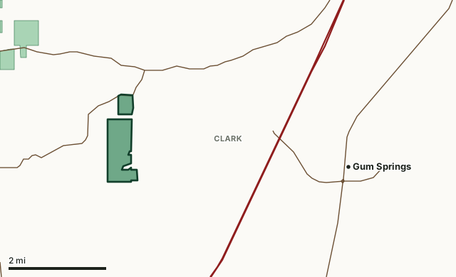
Terre Noire Natural Area WMAOther AGFC WMAsLake or riverHighwayCounty line
| Size | 493 acres (AGFC) |
|---|---|
| County | Clark County |
| AGFC WMA zone | 625 |
| Deer zone around it | Zone 12 |
| Area rules | Three-point rule |
| Deer checked, 2024-25 | 7 (1 antlered buck, 1 button buck, 5 does) |
| Phone | 833-363-7638 |
| Nearest towns | Gum Springs (4 mi), Arkadelphia (6 mi) and Caddo Valley (8 mi) |
When are the 2026-27 seasons on Terre Noire Natural Area WMA?
AGFC sets each WMA's own dates and limits. These are its big game seasons for the area.
2026-27 Closed Seasons
- Deer firearms
- Bear firearms
- Turkey
- Alligator
2026-27 Deer
- Deer Archery: Aug. 29-31 (one antlered buck only); Sept. 26-Feb. 28.
- WMA Bag Limit: Three deer, no more than two antlered bucks (3-Point Rule applies), which may include:
- Two antlered bucks with archery,
- Three antlerless deer with archery.
2026 Bear
- Bear Archery: Dec. 19-25. Season closes earlier when Bear Zone 3 quota is reached.
Other seasons AGFC lists for the area: crow, quail, rabbit and squirrel. Their dates are on AGFC's page.
Source: AGFC, Terre Noire Natural Area WMA, read October 2026. AGFC's page and its regulations are the final word.
How many deer are taken on Terre Noire Natural Area WMA?
Hunters checked 7 deer on Terre Noire Natural Area WMA in the 2024-25 season. Over the 3 seasons in AGFC's records, the area averaged 5 deer a season.
| Season | Deer checked | Antlered bucks | Button bucks | Does |
|---|---|---|---|---|
| 2024-25 | 7 | 1 | 1 | 5 |
| 2023-24 | 5 | 2 | 2 | 1 |
| 2022-23 | 3 | 1 | 1 | 1 |
Source: AGFC deer check records, 2022-23 to 2024-25, counted by FilledTag from the records AGFC files under this WMA.
What should you know before hunting Terre Noire Natural Area WMA?
Area Notes
Free georeferenced maps are available for this WMA and others at https://apps.agfc.com/maps/. These maps are frequently updated and include features such as parking, types of road and land boundaries.
Ownership
Arkansas Natural Heritage Commission
From AGFC's page for the area.
Which county is Terre Noire Natural Area WMA in?
| County | Acres of the area in it | County deer, 2024-25 | Rank of 75 |
|---|---|---|---|
| Clark County | 481 | 5,965 | 2nd |
Acres measured by FilledTag on AGFC WMA boundaries and the U.S. Census Bureau 2024 county boundaries. County harvest: AGFC deer check records, 2022-23 to 2024-25.
How do you get to Terre Noire Natural Area WMA?
Highways within 5 miles: I-30, AR 51, AR 53 and AR 26. Nearest towns: Gum Springs (4 miles), Arkadelphia (6 miles), Caddo Valley (8 miles) and Okolona (10 miles).
The closest other WMAs with a page here: Big Timber WMA (1.9 miles), DeGray Lake WMA (6 miles), Jack Mountain WMA (17.1 miles) and Poison Springs WMA (22.1 miles).
Questions hunters ask
When is deer season on Terre Noire Natural Area WMA in 2026-27?
AGFC's dates for Terre Noire Natural Area WMA: Deer Archery, Aug. 29-31 (one antlered buck only); Sept. 26-Feb. 28.
How many deer can you take on Terre Noire Natural Area WMA?
Three deer, no more than two antlered bucks (3-Point Rule applies), which may include: two antlered bucks with archery and three antlerless deer with archery. (AGFC's 2026-27 rules for the area).
How many deer were killed on Terre Noire Natural Area WMA last season?
Hunters checked 7 deer on Terre Noire Natural Area WMA in the 2024-25 season: 1 antlered buck, 1 button buck and 5 does, by AGFC's deer check records. The 3-season average is 5.
What county is Terre Noire Natural Area WMA in?
All of it is in Clark County, by AGFC's boundary.
Get a Arkansas hunt plan when they open
Hunt plans for Arkansas are coming. Join the list and you'll hear first. The first 50 hunters in each new state get their plan free.
Until then, the free FilledTag app for iPhone has a map that works in every state, Arkansas included.
Where these numbers come from
- Seasons, limits, size and area notes: AGFC's page for each WMA (AGFC Wildlife Management Areas).
- Deer harvest on the area and by county: AGFC deer check records, 2022-23 to 2024-25.
- Boundary: AGFC WMA boundaries. Counties, highways and towns: U.S. Census Bureau 2024 county boundaries; U.S. Census Bureau TIGER/Line 2024 roads; U.S. Census Bureau 2024 Gazetteer. Refuges: U.S. Fish and Wildlife Service refuge boundaries.
FilledTag is not part of the Arkansas Game and Fish Commission. Numbers are copied from AGFC or measured from public maps; nothing on this page is estimated by FilledTag.
Arkansas hunting All Arkansas WMAs Clark County deer harvest