Cache Creek Wildlife Area: hunting rules and map
Cache Creek Wildlife Area is 2,520 acres of CDFW land in Lake County, in CDFW's North Central Region. Title 14, Section 551 lists it as Type C: open daily for hunting all legal species without a hunting pass, except where CDFW's area rules say otherwise. It lies in deer Zone A, where CDFW estimates 9,184 deer were taken in 2025.
Data updated October 2026. Rules: CDFW's 2026-2027 land use regulations (updated July 1, 2026). Boundary and acres: CDFW. Zones: CDFW. Land around it: CPAD 2026a.
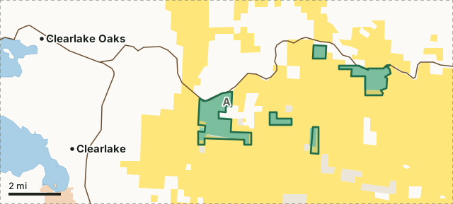
BLMCDFW landOther state or federal landCache Creek WADeer zone lineLake or riverHighway
| Size | 2,520 acres (CDFW boundary) |
|---|---|
| CDFW region | Region 2, North Central Region |
| County | Lake |
| Wildlife area type | Type C |
| Closures | The use of dogs for wild pig hunting is prohibited. |
| Camping | No motorhomes or camp trailers permitted. |
| Deer zone | Zone A |
| Elk zone | Cache Creek, Bear Valley |
| Nearest towns | Clearlake (5 mi), Lower Lake (5 mi) and Spring Valley (6 mi) |
What are CDFW's rules for Cache Creek Wildlife Area?
As a Type C area, Cache Creek WA needs no hunting pass; the rows below are CDFW's own limits for it.
| Rule | Unit | CDFW's words |
|---|---|---|
| Camping | Whole area | No motorhomes or camp trailers permitted. No camping within 1/4 mile of designated parking areas. |
| Closures and restrictions | Whole area | The use of dogs for wild pig hunting is prohibited. |
Source: CDFW 2026-2027 Waterfowl, Upland Game, and Public Use of Department Lands Regulations, Title 14, Section 551. CDFW's page for Cache Creek Wildlife Area has maps and contacts. Deer, elk and pronghorn hunting also follow the zone's own season and tag.
What does CDFW say about Cache Creek Wildlife Area?
The Cache Creek Wildlife Area is approximately 2,300 acres, of which the majority is fairly steep. Typical interior coast range chaparral species and oak-gray pine stands are found on the property. Associated with chamise stands are interior live oak, scrub oak, deer brush, toyon, birchleaf mahogany, yerba santa, gray pine, and others. A regular winter visitor to the area is the bald eagle which can be seen roosting or soaring from mid October through mid August.
The area has two units: North Fork Cache Creek and Harley Gulch. The two units are cooperatively managed by The Bureau of Land Management, Yolo County Parks, and CDFW. Both units provide access to the BLM Cache Creek Natural Area.
On hunting, CDFW's page says: Deer, elk, black bear, wild pig, rabbit, wild turkey, quail, pigeon, and dove may be present.
CDFW lists big game, small game and upland game birds hunting for the area, and also wildlife viewing and hiking trails.
Facilities, in CDFW's words: Restrooms are located at trailheads.
From CDFW's page for Cache Creek Wildlife Area, read October 2026.
Which hunt zones is Cache Creek Wildlife Area in?
CDFW's numbers for each zone are for the whole zone, not the wildlife area alone.
| Zone | Acres of Cache Creek WA in it | CDFW's latest numbers for the zone |
|---|---|---|
| Deer Zone A | 2,520 | 9,184 deer taken in 2025, 34.2% hunter success; 2026 general season August 8 to September 20 |
| Cache Creek elk zone | 2,516 | 4 elk taken in 2022 |
| Bear Valley elk zone | 4 | 2 elk taken in 2022 |
Harvest: CDFW California Deer Harvest Statistics (2020 to 2025); CDFW Elk Hunt Statistics. Acres measured by FilledTag from CDFW's boundaries.
What public land is around Cache Creek Wildlife Area?
Within 4 miles of its boundary, CPAD 2026a maps 50,266 acres of BLM land, 2,304 acres of CDFW land and 1,285 acres of other state or federal land.
How do you get to Cache Creek Wildlife Area?
CDFW's directions: Harley Gulch Unit is approximately 10 miles southeast from the junction with Hwy 53, near Walker Ridge Road. Park at the Judge Davis Trailhead parking area and head south on the trail. North Fork Cache Creek Unit is approximately 5 miles southeast from the junction with Hwy 53. Park at the Redbud Trailhead parking area and head south on the trail. North Central Region Rancho Cordova Office: (916) 358-2900 Maps
CDFW's location note: 25-29 miles west of Williams and Interstate 5, on the south side of Hwy 20. Highways within 8 miles: CA 20, CA 53, CA 16 and CA 29. Nearest towns: Clearlake (5 miles), Lower Lake (5 miles), Spring Valley (6 miles) and Clearlake Oaks (6 miles).
Questions hunters ask
Can you hunt on Cache Creek Wildlife Area?
Yes. Section 551 lists it as Type C. Type C areas are open daily for all legal species, unless CDFW's area rules say otherwise. CDFW's closure: The use of dogs for wild pig hunting is prohibited.
Can you camp on Cache Creek Wildlife Area?
CDFW's rule: No motorhomes or camp trailers permitted. No camping within 1/4 mile of designated parking areas. Where camping is allowed, a visitor may stay up to seven nights in a row and fourteen nights a year (Section 550(p)).
Which deer zone is Cache Creek Wildlife Area in?
All of it is in deer Zone A, by CDFW's boundaries. CDFW estimates 9,184 deer were taken in Zone A in 2025, across the whole zone.
What is the closest town to Cache Creek Wildlife Area?
Clearlake (5 miles), Lower Lake (5 miles) and Spring Valley (6 miles), by the Census Bureau's places.
Get a California hunt plan when they open
Hunt plans for California are coming. Join the list and you'll hear first. The first 50 hunters in each new state get their plan free.
Until then, the free FilledTag app for iPhone has a map that works in every state, California included.
Where these facts come from
- Rules: CDFW 2026-2027 Waterfowl, Upland Game, and Public Use of Department Lands Regulations.
- Boundary and acres: CDFW public access lands (BIOS ds3077); CDFW, Cache Creek Wildlife Area.
- Zones: CDFW BIOS zone layers. Surrounding public land: California Protected Areas Database (CPAD) 2026a.
- Deer harvest: CDFW California Deer Harvest Statistics (2020 to 2025).
FilledTag is not part of the California Department of Fish and Wildlife.