French Valley Wildlife Area: hunting rules and map
French Valley Wildlife Area is 671 acres of CDFW land in Riverside County, in CDFW's Inland Deserts Region. Title 14, Section 551 lists it as Type C: open daily for hunting all legal species without a hunting pass, except where CDFW's area rules say otherwise. It lies in deer Zone D15, where CDFW estimates 109 deer were taken in 2025.
Data updated October 2026. Rules: CDFW's 2026-2027 land use regulations (updated July 1, 2026). Boundary and acres: CDFW. Zones: CDFW. Land around it: CPAD 2026a.
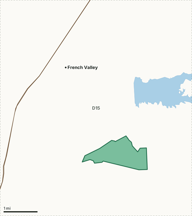
BLMCDFW landFrench Valley WADeer zone lineLake or riverHighway
| Size | 671 acres (CDFW boundary) |
|---|---|
| CDFW region | Region 6, Inland Deserts Region |
| County | Riverside |
| Wildlife area type | Type C |
| Camping | Not listed in section 551(m), so not allowed |
| Deer zone | Zone D15 |
| Nearest towns | French Valley (3 mi), Temecula (5 mi) and Murrieta (5 mi) |
What are CDFW's rules for French Valley Wildlife Area?
As a Type C area, French Valley WA needs no hunting pass.
CDFW lists no rules for French Valley Wildlife Area beyond those for every wildlife area (Sections 550 and 551).
Source: CDFW 2026-2027 Waterfowl, Upland Game, and Public Use of Department Lands Regulations, Title 14, Section 551. CDFW's page for French Valley Wildlife Area has maps and contacts. Deer, elk and pronghorn hunting also follow the zone's own season and tag.
What does CDFW say about French Valley Wildlife Area?
French Valley Wildlife Area is 702 acres of coastal sage scrub, southern willow scrub, grasslands, eucalyptus woodlands, and prior dry-land farming agricultural lands. It has rolling hills with elevations from 1,300'-1,600'. It was designated as a wildlife area by the Fish and Game Commission in 2007.
On hunting, CDFW's page says: Dove, quail, and rabbits may be present.
CDFW lists small game and upland game birds hunting for the area, and also wildlife viewing and hiking trails.
From CDFW's page for French Valley Wildlife Area, read October 2026.
Which hunt zones is French Valley Wildlife Area in?
CDFW's numbers for each zone are for the whole zone, not the wildlife area alone.
| Zone | Acres of French Valley WA in it | CDFW's latest numbers for the zone |
|---|---|---|
| Deer Zone D15 | 671 | 109 deer taken in 2025, 14.8% hunter success; 2026 general season October 10 to November 8 |
Harvest: CDFW California Deer Harvest Statistics (2020 to 2025). Acres measured by FilledTag from CDFW's boundaries.
What public land is around French Valley Wildlife Area?
Within 4 miles of its boundary, CPAD 2026a maps 671 acres of CDFW land and 153 acres of BLM land.
How do you get to French Valley Wildlife Area?
CDFW's directions: From Temecula head north on Interstate 15 to Hwy 79 North to Benton Road, turn east, then south on Washington Street which becomes Borel Road. Turn south on Buck Road. Or, take Rancho California Road northeast from I-15 to Buck Road and turn left. Entry off of Buck Road.
CDFW's location note: 5 miles northeast of Temecula, south of Lake Skinner. Highways within 8 miles: CA 79, I-15 and I-215. Nearest towns: French Valley (3 miles), Temecula (5 miles), Murrieta (5 miles) and Sage (9 miles).
Questions hunters ask
Can you hunt on French Valley Wildlife Area?
Yes. Section 551 lists it as Type C. Type C areas are open daily for all legal species, unless CDFW's area rules say otherwise.
Can you camp on French Valley Wildlife Area?
No. Section 551(m) does not list French Valley Wildlife Area, and camping is prohibited on wildlife areas it does not list (Section 550(p)).
Which deer zone is French Valley Wildlife Area in?
All of it is in deer Zone D15, by CDFW's boundaries. CDFW estimates 109 deer were taken in Zone D15 in 2025, across the whole zone.
What is the closest town to French Valley Wildlife Area?
French Valley (3 miles), Temecula (5 miles) and Murrieta (5 miles), by the Census Bureau's places.
Get a California hunt plan when they open
Hunt plans for California are coming. Join the list and you'll hear first. The first 50 hunters in each new state get their plan free.
Until then, the free FilledTag app for iPhone has a map that works in every state, California included.
Where these facts come from
- Rules: CDFW 2026-2027 Waterfowl, Upland Game, and Public Use of Department Lands Regulations.
- Boundary and acres: CDFW public access lands (BIOS ds3077); CDFW, French Valley Wildlife Area.
- Zones: CDFW BIOS zone layers. Surrounding public land: California Protected Areas Database (CPAD) 2026a.
- Deer harvest: CDFW California Deer Harvest Statistics (2020 to 2025).
FilledTag is not part of the California Department of Fish and Wildlife.