CDFW Inland Deserts Region: deer, elk and pronghorn hunting
CDFW's Inland Deserts Region, run from Ontario, is 47.7% national forest, BLM or CDFW land (CPAD 2026a). It holds most of the ground of 8 deer zones and 5 elk zones. By CDFW's 2025 estimates, the most deer were taken in Zone D14 (503), Zone X12 (193) and Zone X9a (160).
Data updated October 2026. Harvest: CDFW's 2025 deer harvest report. Land: CPAD 2026a. Region boundary: CDFW.
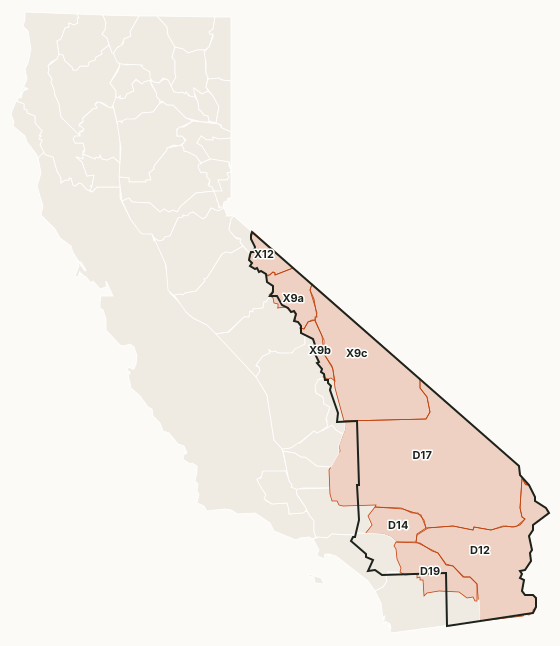
The Inland Deserts Region covers the eastern Sierra, the Mojave and the Colorado Desert. BLM land is most of its public ground, with the Inyo and San Bernardino national forests; Death Valley and Joshua Tree national parks are closed to hunting. The Owens Valley tule elk zones, zones D-12, D-14, D-17 and D-19 and the X-9 and X-12 zones lie mostly in it.
Which deer zones are in CDFW's Inland Deserts Region?
Each deer zone is listed under the region holding most of its ground. CDFW's 2025 numbers and the public land in each:
| Zone | Square miles | Public land | 2026 tags | Deer taken, 2025 | Hunter success, 2025 |
|---|---|---|---|---|---|
| Zone D12 | 8,333 | 52.3% | 950 | 121 | 12.8% |
| Zone D14 | 1,704 | 53.4% | 3,000 | 503 | 16.8% |
| Zone D17 | 19,555 | 47.1% | 500 | 58 | 11.6% |
| Zone D19 | 2,693 | 23.2% | 1,500 | 156 | 10.4% |
| Zone X9a | 1,946 | 84% | 270 | 160 | 62.7% |
| Zone X9b | 741 | 86.6% | 230 | 65 | 29.4% |
| Zone X9c | 8,711 | 30.8% | 325 | 77 | 24% |
| Zone X12 | 1,031 | 84.4% | 350 | 193 | 58.7% |
Harvest: CDFW 2025 California Deer Harvest Statistics. Public land measured by FilledTag from California Protected Areas Database (CPAD) 2026a.
CDFW deer hunts with ground of their own in the region: Goodale Buck Hunt (G-3), Round Valley (G-39, J-12), San Bernardino Apprentice Either-Sex Deer Hunt (J-11) and Riverside Apprentice Either-Sex Deer Hunt (J-14).
Elk and pronghorn zones in the Inland Deserts Region
Elk: Goodale (2 elk taken in 2022), Independence (3 elk taken in 2022), Lone Pine (1 elk taken in 2022), West Tinemaha (1 elk taken in 2022) and Whitney (2 elk taken in 2022).
Sources: CDFW Elk Hunt Statistics; CDFW Pronghorn Hunt Statistics.
How much public land is in the Inland Deserts Region?
| Manager | Acres | Share of the region |
|---|---|---|
| BLM | 10,814,768 | 37.3% |
| National Park Service | 5,496,964 | 19% |
| National forest | 2,743,385 | 9.5% |
| Other state or federal land | 511,863 | 1.8% |
| State park | 263,073 | 0.9% |
| CDFW land | 252,008 | 0.9% |
| National wildlife refuge | 56,903 | 0.2% |
Measured by FilledTag inside CDFW's region boundary from California Protected Areas Database (CPAD) 2026a. "Public land" on this page means national forest, BLM and CDFW land, the three managers whose ground is open to hunting under their own rules. National Park Service land, state parks and most other public ground are listed but not counted: hunting there is closed or limited. Land held by cities, counties, districts and private groups is not shown.
CDFW lands open to hunting in the Inland Deserts Region
28 CDFW wildlife areas and ecological reserves in the region have a page here, each with CDFW's 2026 rules:
- Baldwin Lake Ecological Reserve: 163 acres
- Burcham & Wheeler Flats Wildlife Area: 1,349 acres
- Buttermilk Country Wildlife Area: 325 acres
- By Day Creek Ecological Reserve: 454 acres
- Camp Cady Wildlife Area: 1,912 acres
- Cartago Wildlife Area: 232 acres
- East Walker River Wildlife Area: 1,348 acres
- Fish Slough Ecological Reserve: 184 acres
- French Valley Wildlife Area: 671 acres
- Green Creek Wildlife Area: 2,754 acres
- Imperial Wildlife Area: 7,808 acres
- Indian Joe Springs Ecological Reserve: 590 acres
- Kelso Peak & Old Dad Mountains Wildlife Area: 103,507 acres
- Marble Mountains Wildlife Area: 54,802 acres
- Oasis Spring Ecological Reserve: 486 acres
- Palo Verde Ecological Reserve: 2,078 acres
- Peninsular Ranges Ecological Reserve: 3,347 acres
- Pickel Meadow Wildlife Area: 968 acres
- Piute Creek Ecological Reserve: 143 acres
- River Spring Lakes Ecological Reserve: 629 acres
- Round Valley Wildlife Area: 377 acres
- Saline Valley Ecological Reserve: 531 acres
- San Felipe Creek Ecological Reserve: 1,996 acres
- San Jacinto Wildlife Area: 18,245 acres
- Santa Rosa Wildlife Area: 117,197 acres
- Sky Valley Ecological Reserve: 1,778 acres
- Slinkard - Little Antelope Wildlife Area: 11,451 acres
- West Walker River Wildlife Area: 753 acres
Get a California hunt plan when they open
Hunt plans for California are coming. Join the list and you'll hear first. The first 50 hunters in each new state get their plan free.
Until then, the free FilledTag app for iPhone has a map that works in every state, California included.
Sources: CDFW California Deer Harvest Statistics (2020 to 2025); California Protected Areas Database (CPAD) 2026a; CDFW terrestrial regions; CDFW 2026-2027 Waterfowl, Upland Game, and Public Use of Department Lands Regulations. FilledTag is not part of the California Department of Fish and Wildlife.
California hunting Region 1 Region 2 Region 3 Region 4 Region 5