CDFW Northern Region: deer, elk and pronghorn hunting
CDFW's Northern Region, run from Redding, is 46.5% national forest, BLM or CDFW land (CPAD 2026a). It holds most of the ground of 16 deer zones, 5 elk zones and 6 pronghorn zones. By CDFW's 2025 estimates, the most deer were taken in Zone B1 (3,992), Zone B2 (3,565) and Zone B5 (1,309).
Data updated October 2026. Harvest: CDFW's 2025 deer harvest report. Land: CPAD 2026a. Region boundary: CDFW.
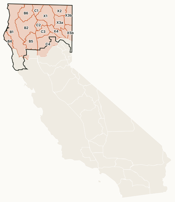
The Northern Region takes in the northwest coast, the Klamath Mountains and the northeast plateau. Its largest public ground is the Shasta-Trinity, Modoc, Klamath, Six Rivers and Lassen national forests and BLM land in the northeast. All six pronghorn zones, the Roosevelt elk zones and the Northeastern elk zone are here, with most of the B zones, all four C zones and zones X-1 to X-5b.
Which deer zones are in CDFW's Northern Region?
Each deer zone is listed under the region holding most of its ground. CDFW's 2025 numbers and the public land in each:
| Zone | Square miles | Public land | 2026 tags | Deer taken, 2025 | Hunter success, 2025 |
|---|---|---|---|---|---|
| Zone B1 | 6,187 | 43.4% | 35,000* | 3,992 | 32.5% |
| Zone B2 | 3,842 | 74.2% | 35,000* | 3,565 | 32.5% |
| Zone B4 | 934 | 13.3% | 35,000* | 296 | 32.5% |
| Zone B5 | 2,054 | 21% | 35,000* | 1,309 | 32.5% |
| Zone B6 | 2,137 | 62.3% | 35,000* | 955 | 32.5% |
| Zone C1 | 925 | 25.1% | 8,150* | 284 | 30.1% |
| Zone C2 | 927 | 48.9% | 8,150* | 455 | 30.1% |
| Zone C3 | 1,313 | 17.4% | 8,150* | 585 | 30.1% |
| Zone C4 | 3,864 | 30.6% | 8,150* | 1,129 | 30.1% |
| Zone X1 | 2,904 | 55.2% | 760 | 331 | 45.5% |
| Zone X2 | 1,620 | 72.3% | 190 | 78 | 46.7% |
| Zone X3a | 1,533 | 52.4% | 355 | 209 | 63% |
| Zone X3b | 1,543 | 61.6% | 500 | 161 | 34.5% |
| Zone X4 | 1,115 | 61.9% | 480 | 173 | 37.3% |
| Zone X5a | 543 | 72.4% | 75 | 47 | 68.1% |
| Zone X5b | 933 | 73.1% | 50 | 30 | 68.2% |
* A quota shared by a group of zones (B, C or D3-5). Harvest: CDFW 2025 California Deer Harvest Statistics. Public land measured by FilledTag from California Protected Areas Database (CPAD) 2026a.
CDFW deer hunts with ground of their own in the region: Doyle Muzzleloading Rifle Buck Hunt (M-3), Bass Hill (M-8, A-26), Devil's Garden (M-9, A-27), Tehama Wildlife Area Apprentice Buck Hunt (J-3), Shasta-Trinity Apprentice Buck Hunt (J-4), East Tehama Apprentice Either-Sex Deer Hunt (J-21) and Covelo Archery Buck Hunt (A-30).
Elk and pronghorn zones in the Northern Region
Elk: Marble Mountains (34 elk taken in 2022), Mendocino (2 elk taken in 2022), Northeastern (26 elk taken in 2022), Northwestern (20 elk taken in 2022) and Siskiyou (20 elk taken in 2022). Pronghorn: Zone 1, Mount Dome (1 taken in 2023), Zone 2, Clear Lake (12 taken in 2023), Zone 3, Likely Tables (22 taken in 2023), Zone 4, Lassen (65 taken in 2023), Zone 5, Big Valley (12 taken in 2023) and Zone 6, Surprise Valley (11 taken in 2023).
Sources: CDFW Elk Hunt Statistics; CDFW Pronghorn Hunt Statistics.
How much public land is in the Northern Region?
| Manager | Acres | Share of the region |
|---|---|---|
| National forest | 7,937,935 | 37.1% |
| BLM | 1,837,123 | 8.6% |
| National Park Service | 259,899 | 1.2% |
| State park | 165,576 | 0.8% |
| Other state or federal land | 160,755 | 0.8% |
| CDFW land | 158,957 | 0.7% |
| National wildlife refuge | 121,326 | 0.6% |
Measured by FilledTag inside CDFW's region boundary from California Protected Areas Database (CPAD) 2026a. "Public land" on this page means national forest, BLM and CDFW land, the three managers whose ground is open to hunting under their own rules. National Park Service land, state parks and most other public ground are listed but not counted: hunting there is closed or limited. Land held by cities, counties, districts and private groups is not shown.
CDFW lands open to hunting in the Northern Region
27 CDFW wildlife areas and ecological reserves in the region have a page here, each with CDFW's 2026 rules:
- Ash Creek Wildlife Area: 14,566 acres
- Bass Hill Wildlife Area: 5,483 acres
- Big Lagoon Wildlife Area: 1,458 acres
- Biscar Wildlife Area: 552 acres
- Butte Valley Wildlife Area: 13,325 acres
- Cantara-Ney Springs Wildlife Area: 153 acres
- Cinder Flats Wildlife Area: 730 acres
- Dales Lake Ecological Reserve: 377 acres
- Doyle Wildlife Area: 10,424 acres
- Dutch Flat Wildlife Area: 157 acres
- Eel River Wildlife Area: 2,348 acres
- Elk River Wildlife Area: 100 acres
- Fay Slough Wildlife Area: 477 acres
- Fitzhugh Creek Wildlife Area: 2,135 acres
- Honey Lake Wildlife Area: 7,716 acres
- Horseshoe Ranch Wildlife Area: 5,099 acres
- Lake Earl Wildlife Area: 5,977 acres
- Mad River Slough Wildlife Area: 577 acres
- Merrill's Landing Wildlife Area: 297 acres
- Mouth of Cottonwood Creek Wildlife Area: 1,034 acres
- Pine Creek Wildlife Area: 2,011 acres
- Shasta Valley Wildlife Area: 4,665 acres
- Silver Creek Wildlife Area: 2,007 acres
- South Spit Wildlife Area: 953 acres
- Surprise Valley Wildlife Area: 464 acres
- Tehama Wildlife Area: 44,406 acres
- Willow Creek Wildlife Area: 2,753 acres
Get a California hunt plan when they open
Hunt plans for California are coming. Join the list and you'll hear first. The first 50 hunters in each new state get their plan free.
Until then, the free FilledTag app for iPhone has a map that works in every state, California included.
Sources: CDFW California Deer Harvest Statistics (2020 to 2025); California Protected Areas Database (CPAD) 2026a; CDFW terrestrial regions; CDFW 2026-2027 Waterfowl, Upland Game, and Public Use of Department Lands Regulations. FilledTag is not part of the California Department of Fish and Wildlife.
California hunting Region 2 Region 3 Region 4 Region 5 Region 6