CDFW Central Region: deer, elk and pronghorn hunting
CDFW's Central Region, run from Fresno, is 23.1% national forest, BLM or CDFW land (CPAD 2026a). It holds most of the ground of 7 deer zones and 3 elk zones. By CDFW's 2025 estimates, the most deer were taken in Zone A (9,184), Zone D7 (1,300) and Zone D6 (1,119).
Data updated October 2026. Harvest: CDFW's 2025 deer harvest report. Land: CPAD 2026a. Region boundary: CDFW.
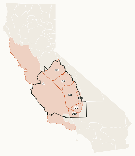
The Central Region stretches from the central coast across the San Joaquin Valley to the southern Sierra Nevada. Its national forests are the Sierra, Sequoia, Stanislaus and Los Padres; Yosemite, Kings Canyon and Sequoia national parks are closed to hunting. Most of Zone A, zones D-6 to D-10, X-10 and the central coast tule elk zones lie in it, with the Tehachapi Rocky Mountain elk zone.
Which deer zones are in CDFW's Central Region?
Each deer zone is listed under the region holding most of its ground. CDFW's 2025 numbers and the public land in each:
| Zone | Square miles | Public land | 2026 tags | Deer taken, 2025 | Hunter success, 2025 |
|---|---|---|---|---|---|
| Zone A | 35,615 | 11.8% | 65,000 | 9,184 | 34.2% |
| Zone D6 | 5,021 | 29.4% | 10,000 | 1,119 | 11.2% |
| Zone D7 | 3,762 | 50.6% | 9,000 | 1,300 | 14.5% |
| Zone D8 | 5,794 | 26.4% | 8,000 | 916 | 16.2% |
| Zone D9 | 1,457 | 47.7% | 2,000 | 342 | 17.1% |
| Zone D10 | 1,379 | 2.4% | 700 | 241 | 36.9% |
| Zone X10 | 945 | 93.9% | 400 | 59 | 14.9% |
Harvest: CDFW 2025 California Deer Harvest Statistics. Public land measured by FilledTag from California Protected Areas Database (CPAD) 2026a.
CDFW deer hunts with ground of their own in the region: Kern River Deer Herd Buck Hunt (G-6), Ventana Wilderness Buck Hunt (G-21), Anderson Flat (G-37, J-15, A-21), San Luis Obispo Muzzleloading Rifle/Archery Either-Sex Deer Hunt (MA-1), Fort Hunter Liggett (J-10, A-33) and Monterey Archery Either-Sex Deer Hunt (A-24).
Elk and pronghorn zones in the Central Region
Elk: Fort Hunter Liggett (23 elk taken in 2022), La Panza (19 elk taken in 2022) and San Luis Reservoir (4 elk taken in 2022).
Sources: CDFW Elk Hunt Statistics; CDFW Pronghorn Hunt Statistics.
How much public land is in the Central Region?
| Manager | Acres | Share of the region |
|---|---|---|
| National forest | 3,939,204 | 16.3% |
| National Park Service | 1,638,624 | 6.8% |
| BLM | 1,505,925 | 6.2% |
| State park | 183,781 | 0.8% |
| CDFW land | 156,904 | 0.6% |
| National wildlife refuge | 85,672 | 0.4% |
| Other state or federal land | 65,853 | 0.3% |
Measured by FilledTag inside CDFW's region boundary from California Protected Areas Database (CPAD) 2026a. "Public land" on this page means national forest, BLM and CDFW land, the three managers whose ground is open to hunting under their own rules. National Park Service land, state parks and most other public ground are listed but not counted: hunting there is closed or limited. Land held by cities, counties, districts and private groups is not shown.
CDFW lands open to hunting in the Central Region
25 CDFW wildlife areas and ecological reserves in the region have a page here, each with CDFW's 2026 rules:
- Allensworth Ecological Reserve: 6,471 acres
- Big Sandy Wildlife Area: 757 acres
- Buttonwillow Ecological Reserve: 1,457 acres
- Canebrake Ecological Reserve: 7,564 acres
- Carrizo Plains Ecological Reserve: 40,249 acres
- Cottonwood Creek Wildlife Area: 6,402 acres
- Elkhorn Slough Ecological Reserve: 1,773 acres
- Kerman Ecological Reserve: 1,778 acres
- Kinsman Flat Wildlife Area: 519 acres
- Little Panoche Reservoir Wildlife Area: 893 acres
- Lokern Ecological Reserve: 3,406 acres
- Los Banos Wildlife Area: 6,359 acres
- Mendota Wildlife Area: 12,103 acres
- Monache Meadows Wildlife Area: 234 acres
- Morro Bay Wildlife Area: 1,264 acres
- Moss Landing Wildlife Area: 741 acres
- North Grasslands Wildlife Area: 7,600 acres
- O'Neill Forebay Wildlife Area: 670 acres
- Panoche Hills Ecological Reserve: 585 acres
- Pleasant Valley Ecological Reserve: 1,233 acres
- San Luis Obispo Wildlife Area: 457 acres
- San Luis Reservoir Wildlife Area: 1,100 acres
- Stone Corral Ecological Reserve: 968 acres
- Volta Wildlife Area: 3,782 acres
- West Hilmar Wildlife Area: 313 acres
Get a California hunt plan when they open
Hunt plans for California are coming. Join the list and you'll hear first. The first 50 hunters in each new state get their plan free.
Until then, the free FilledTag app for iPhone has a map that works in every state, California included.
Sources: CDFW California Deer Harvest Statistics (2020 to 2025); California Protected Areas Database (CPAD) 2026a; CDFW terrestrial regions; CDFW 2026-2027 Waterfowl, Upland Game, and Public Use of Department Lands Regulations. FilledTag is not part of the California Department of Fish and Wildlife.
California hunting Region 1 Region 2 Region 3 Region 5 Region 6