Panoche Hills Ecological Reserve: hunting rules and map
Panoche Hills Ecological Reserve is 585 acres of CDFW land in Fresno County, in CDFW's Central Region, one of the ecological reserves where Title 14, Section 630(d) makes hunting a designated public use. CDFW's rule for it: Allowed from July 1 through January 31. It lies in deer Zone A, where CDFW estimates 9,184 deer were taken in 2025.
Data updated October 2026. Rules: CDFW's 2026-2027 land use regulations (updated July 1, 2026). Boundary and acres: CDFW. Zones: CDFW. Land around it: CPAD 2026a.
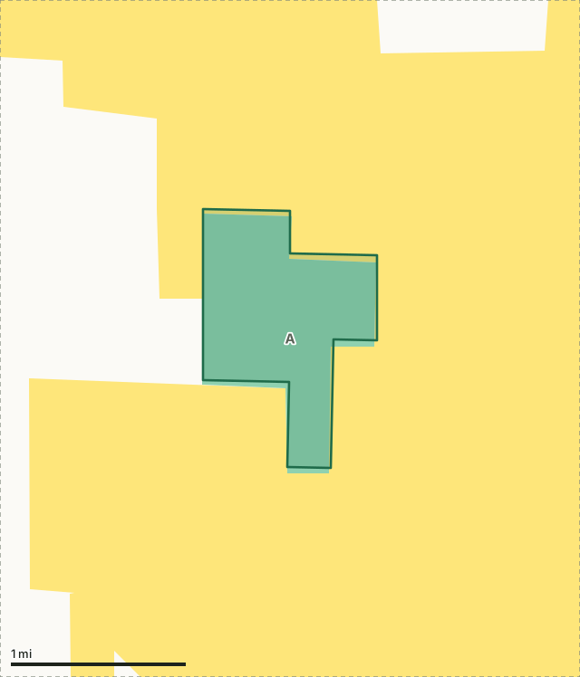
BLMCDFW landPanoche Hills ERDeer zone lineLake or riverHighway
| Size | 585 acres (CDFW boundary) |
|---|---|
| CDFW region | Region 4, Central Region |
| County | Fresno |
| Hunting | Allowed from July 1 through January 31. |
| Deer zone | Zone A |
| Elk zone | Gabilan |
| Nearest towns | South Dos Palos (21 mi), Firebaugh (22 mi) and Dos Palos (22 mi) |
What are CDFW's rules for Panoche Hills Ecological Reserve?
Section 630(d): Allowed from July 1 through January 31.
CDFW lists no rules for Panoche Hills Ecological Reserve beyond those for every ecological reserve (Sections 550 and 630).
Source: CDFW 2026-2027 Waterfowl, Upland Game, and Public Use of Department Lands Regulations, Title 14, Section 630. CDFW's page for Panoche Hills Ecological Reserve has maps and contacts. Deer, elk and pronghorn hunting also follow the zone's own season and tag.
What does CDFW say about Panoche Hills Ecological Reserve?
The habitat at the 596-acre Panoche Hills Ecological Reserve is predominantly shrub grassland, typical of the interior coastal foothills. Characteristic trees and shrubs include juniper, Mormon tea, saltbush, and buckwheat. Common grasses are predominantly exotics of Mediterranean origin. Wildlife species which may occur at the reserve include quail, dove, hawks, coyote, foxes, deer, squirrels, rabbits, snakes, and lizards.
CDFW lists big game, small game and upland game birds hunting for the area, and also wildlife viewing.
From CDFW's page for Panoche Hills Ecological Reserve, read October 2026.
Which hunt zones is Panoche Hills Ecological Reserve in?
CDFW's numbers for each zone are for the whole zone, not the reserve alone.
| Zone | Acres of Panoche Hills ER in it | CDFW's latest numbers for the zone |
|---|---|---|
| Deer Zone A | 585 | 9,184 deer taken in 2025, 34.2% hunter success; 2026 general season August 8 to September 20 |
| Gabilan elk zone | 585 | Tags through the big game drawing |
Harvest: CDFW California Deer Harvest Statistics (2020 to 2025); CDFW Elk Hunt Statistics. Acres measured by FilledTag from CDFW's boundaries.
What public land is around Panoche Hills Ecological Reserve?
Within 4 miles of its boundary, CPAD 2026a maps 28,175 acres of BLM land and 580 acres of CDFW land.
How do you get to Panoche Hills Ecological Reserve?
CDFW's directions: I-5 exit Little Panoche Rd 18 mi west of Mendota. Go west about 12 mi. Take dirt road south of Mercey Hot Springs east to reserve.
Highways within 8 miles: I-5. Nearest towns: South Dos Palos (21 miles), Firebaugh (22 miles), Dos Palos (22 miles) and Mendota (23 miles).
Questions hunters ask
Can you hunt on Panoche Hills Ecological Reserve?
Yes, within CDFW's limits in Section 630(d): Allowed from July 1 through January 31. Hunting is prohibited on any ecological reserve that section does not list.
Can you camp on Panoche Hills Ecological Reserve?
No. Camping is prohibited on all CDFW ecological reserves (Section 550(p)(4)).
Which deer zone is Panoche Hills Ecological Reserve in?
All of it is in deer Zone A, by CDFW's boundaries. CDFW estimates 9,184 deer were taken in Zone A in 2025, across the whole zone.
What is the closest town to Panoche Hills Ecological Reserve?
South Dos Palos (21 miles), Firebaugh (22 miles) and Dos Palos (22 miles), by the Census Bureau's places.
Get a California hunt plan when they open
Hunt plans for California are coming. Join the list and you'll hear first. The first 50 hunters in each new state get their plan free.
Until then, the free FilledTag app for iPhone has a map that works in every state, California included.
Where these facts come from
- Rules: CDFW 2026-2027 Waterfowl, Upland Game, and Public Use of Department Lands Regulations.
- Boundary and acres: CDFW public access lands (BIOS ds3077); CDFW, Panoche Hills Ecological Reserve.
- Zones: CDFW BIOS zone layers. Surrounding public land: California Protected Areas Database (CPAD) 2026a.
- Deer harvest: CDFW California Deer Harvest Statistics (2020 to 2025).
FilledTag is not part of the California Department of Fish and Wildlife.