CDFW South Coast Region: deer, elk and pronghorn hunting
CDFW's South Coast Region, run from San Diego, is 28% national forest, BLM or CDFW land (CPAD 2026a). It holds most of the ground of 4 deer zones. By CDFW's 2025 estimates, the most deer were taken in Zone D11 (622), Zone D13 (372) and Zone D16 (322).
Data updated October 2026. Harvest: CDFW's 2025 deer harvest report. Land: CPAD 2026a. Region boundary: CDFW.
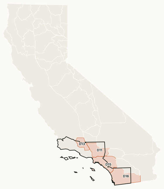
The South Coast Region runs from Santa Barbara to San Diego. The Los Padres, Angeles and Cleveland national forests hold most of its public ground. Zones D-11, D-13, D-15 and D-16 lie mostly in it, along with hunts such as G-13, M-6 and A-22 in San Diego County.
Which deer zones are in CDFW's South Coast Region?
Each deer zone is listed under the region holding most of its ground. CDFW's 2025 numbers and the public land in each:
| Zone | Square miles | Public land | 2026 tags | Deer taken, 2025 | Hunter success, 2025 |
|---|---|---|---|---|---|
| Zone D11 | 2,540 | 44.8% | 5,500 | 622 | 13.8% |
| Zone D13 | 1,305 | 60.4% | 4,000 | 372 | 13.7% |
| Zone D15 | 3,257 | 7.9% | 1,500 | 109 | 14.8% |
| Zone D16 | 4,481 | 30.2% | 3,000 | 322 | 10.7% |
Harvest: CDFW 2025 California Deer Harvest Statistics. Public land measured by FilledTag from California Protected Areas Database (CPAD) 2026a.
CDFW deer hunts with ground of their own in the region: San Diego (G-13, M-6, A-22), Ventura Muzzleloading Rifle Either-Sex Deer Hunt (M-7), Santa Barbara Muzzleloading Rifle/Archery Buck Hunt (MA-3), Los Angeles (J-13, A-31) and Ventura/Los Angeles Late Season Archery Either-Sex Deer Hunt (A-32).
How much public land is in the South Coast Region?
| Manager | Acres | Share of the region |
|---|---|---|
| National forest | 2,194,097 | 25% |
| State park | 680,114 | 7.7% |
| BLM | 205,857 | 2.3% |
| National Park Service | 103,479 | 1.2% |
| CDFW land | 61,718 | 0.7% |
| Other state or federal land | 26,999 | 0.3% |
| National wildlife refuge | 17,968 | 0.2% |
Measured by FilledTag inside CDFW's region boundary from California Protected Areas Database (CPAD) 2026a. "Public land" on this page means national forest, BLM and CDFW land, the three managers whose ground is open to hunting under their own rules. National Park Service land, state parks and most other public ground are listed but not counted: hunting there is closed or limited. Land held by cities, counties, districts and private groups is not shown.
CDFW lands open to hunting in the South Coast Region
8 CDFW wildlife areas and ecological reserves in the region have a page here, each with CDFW's 2026 rules:
- Boden Canyon Ecological Reserve: 1,211 acres
- Burton Mesa Ecological Reserve: 5,202 acres
- Coal Canyon Ecological Reserve: 927 acres
- Hollenbeck Canyon Wildlife Area: 6,848 acres
- Otay Mountain Ecological Reserve: 1,242 acres
- Rancho Jamul Ecological Reserve: 7,039 acres
- San Felipe Valley Wildlife Area: 17,781 acres
- Walker Canyon Ecological Reserve: 512 acres
Get a California hunt plan when they open
Hunt plans for California are coming. Join the list and you'll hear first. The first 50 hunters in each new state get their plan free.
Until then, the free FilledTag app for iPhone has a map that works in every state, California included.
Sources: CDFW California Deer Harvest Statistics (2020 to 2025); California Protected Areas Database (CPAD) 2026a; CDFW terrestrial regions; CDFW 2026-2027 Waterfowl, Upland Game, and Public Use of Department Lands Regulations. FilledTag is not part of the California Department of Fish and Wildlife.
California hunting Region 1 Region 2 Region 3 Region 4 Region 6