CDFW Bay Delta Region: deer, elk and pronghorn hunting
CDFW's Bay Delta Region, run from Napa, is 3.2% national forest, BLM or CDFW land (CPAD 2026a). It holds most of the ground of 1 elk zone.
Data updated October 2026. Harvest: CDFW's 2025 deer harvest report. Land: CPAD 2026a. Region boundary: CDFW.
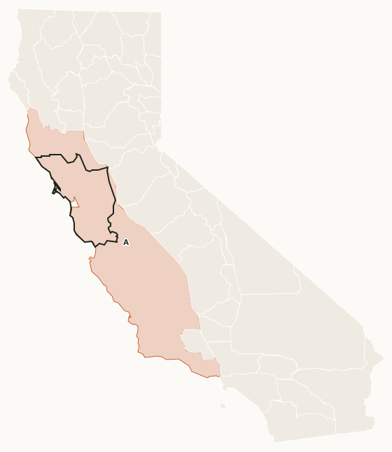
The Bay Delta Region covers the San Francisco Bay Area and the Delta. It has no national forest; its public ground is mostly state parks, national park land and refuges, and no deer zone has most of its ground here. It holds the Grizzly Island tule elk zone, the Alameda and Santa Clara elk zones and the Grizzly Island, Napa-Sonoma Marshes and Yolo Bypass wildlife areas, among others.
Which deer zones are in CDFW's Bay Delta Region?
Each deer zone is listed under the region holding most of its ground, and no deer zone has most of its ground in the Bay Delta Region. Its deer hunting is in Zone A (24.5% of the zone's ground lies in the region).
CDFW deer hunts with ground of their own in the region: Lake Sonoma (J-1, A-25).
Elk and pronghorn zones in the Bay Delta Region
Elk: Grizzly Island (33 elk taken in 2022).
Sources: CDFW Elk Hunt Statistics; CDFW Pronghorn Hunt Statistics.
How much public land is in the Bay Delta Region?
| Manager | Acres | Share of the region |
|---|---|---|
| State park | 206,513 | 3.7% |
| CDFW land | 127,113 | 2.2% |
| National Park Service | 90,468 | 1.6% |
| Other state or federal land | 90,395 | 1.6% |
| BLM | 52,354 | 0.9% |
| National wildlife refuge | 50,981 | 0.9% |
Measured by FilledTag inside CDFW's region boundary from California Protected Areas Database (CPAD) 2026a. "Public land" on this page means national forest, BLM and CDFW land, the three managers whose ground is open to hunting under their own rules. National Park Service land, state parks and most other public ground are listed but not counted: hunting there is closed or limited. Land held by cities, counties, districts and private groups is not shown.
CDFW lands open to hunting in the Bay Delta Region
22 CDFW wildlife areas and ecological reserves in the region have a page here, each with CDFW's 2026 rules:
- Bair Island Ecological Reserve: 1,932 acres
- Calhoun Cut Ecological Reserve: 971 acres
- Canada de Los Osos Ecological Reserve: 5,594 acres
- Cedar Roughs Wildlife Area: 514 acres
- Decker Island Wildlife Area: 28 acres
- Eden Landing Ecological Reserve: 5,796 acres
- Grizzly Island Wildlife Area: 12,860 acres
- Knoxville Wildlife Area: 20,743 acres
- Laguna Wildlife Area: 539 acres
- Lake Sonoma Wildlife Area: 8,554 acres
- Liberty Island Ecological Reserve: 4,317 acres
- Lower Sherman Island Wildlife Area: 3,156 acres
- Miner Slough Wildlife Area: 27 acres
- Napa-Sonoma Marshes Wildlife Area: 15,251 acres
- Petaluma Marsh Wildlife Area: 4,342 acres
- Point Edith Wildlife Area: 727 acres
- Putah Creek Wildlife Area: 672 acres
- Rector Reservoir Wildlife Area: 433 acres
- Rhode Island Wildlife Area: 106 acres
- San Pablo Bay Wildlife Area: 10,854 acres
- Tomales Bay Ecological Reserve: 439 acres
- Yolo Bypass Wildlife Area: 16,601 acres
Get a California hunt plan when they open
Hunt plans for California are coming. Join the list and you'll hear first. The first 50 hunters in each new state get their plan free.
Until then, the free FilledTag app for iPhone has a map that works in every state, California included.
Sources: CDFW California Deer Harvest Statistics (2020 to 2025); California Protected Areas Database (CPAD) 2026a; CDFW terrestrial regions; CDFW 2026-2027 Waterfowl, Upland Game, and Public Use of Department Lands Regulations. FilledTag is not part of the California Department of Fish and Wildlife.
California hunting Region 1 Region 2 Region 4 Region 5 Region 6