Fort Hunter Liggett elk zone: California elk hunting by the numbers
The Fort Hunter Liggett elk zone covers 253 square miles of Monterey County and is hunted for tule elk. 0.4% is national forest, BLM or CDFW land (CPAD 2026a). CDFW's 2026 regulations list 6 hunts here with 30 tags in all. In 2022, CDFW's elk hunt statistics show 23 elk taken on 30 tags, with 3,431 applications for this zone's hunts.
Data updated October 2026. Hunt statistics: CDFW, 2017 to 2022. 2026 hunts and tags: CDFW's 2026-2027 regulations. Land: CPAD 2026a.
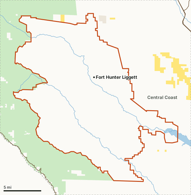
National forestFort Hunter LiggettNeighboring zonesLake or riverHighway
| CDFW region | Region 4, Central Region |
|---|---|
| Elk | Tule elk |
| Counties | Monterey |
| Size | 162,101 acres (253 square miles) |
| Public land | 0.4% (587 acres) |
| Hunts and tags, 2026 | 6 hunts, 30 tags |
| Taken, 2022 | 23 on 30 tags (CDFW) |
| Applications, 2022 | 3,431 for this zone's hunts |
| Towns in and near it | Fort Hunter Liggett, King City and Greenfield |
What elk hunts are in the Fort Hunter Liggett zone in 2026?
CDFW's 2026-2027 regulations list 6 hunts for this zone, 30 tags in all:
| Hunt | Type | 2026 tags | 2026 dates |
|---|---|---|---|
| Fort Hunter Liggett Apprentice - Antlerless | Apprentice | 1 | December 22 to January 3 |
| Fort Hunter Liggett Apprentice - Bull | Apprentice | 1 | December 22 to January 3 |
| Fort Hunter Liggett Archery Antlerless | Archery | 8 | November 7 to 15 |
| Fort Hunter Liggett Archery Either-sex | Archery | 6 | August 1 to 9 |
| Fort Hunter Liggett Period 2 General Methods Antlerless | General Methods | 6 | November 21 to 29 |
| Fort Hunter Liggett Period 3 General Methods Bull | General Methods | 8 | December 22 to January 3 |
Source: CDFW 2026-2027 California Mammal Hunting Regulations, page 85; hunt codes and dates: CDFW 2026 Elk Hunt Dates and General Information.
In CDFW's 2026 Big Game Drawing, 2,877 applications went to this zone's hunts:
| Hunt code | Hunt | Tags | By preference points | Applicants |
|---|---|---|---|---|
| 447 | Fort Hunter Liggett Period 3 - General Methods - Bull | 8 | 6 | 1,656 |
| 450 | Fort Hunter Liggett - Archery - Antlerless | 8 | 6 | 92 |
| 449 | Fort Hunter Liggett - Archery - Either-Sex | 6 | 5 | 517 |
| 448 | Fort Hunter Liggett Period 2 - General Methods - Antlerless | 6 | 5 | 275 |
| 471 | Fort Hunter Liggett Apprentice - General Methods - Antlerless | 1 | 0 | 47 |
| 472 | Fort Hunter Liggett Apprentice - General Methods - Bull | 1 | 0 | 290 |
Source: CDFW 2026 Big Game Drawing statistics. The rest of each quota goes by draw-by-choice. CDFW also prints applicants at each point level.
How many elk are taken in the Fort Hunter Liggett zone?
In 2022, CDFW's elk hunt statistics show 23 taken on 30 tags; 28 tag holders reported. CDFW notes that forest closures affected many elk hunts in 2020 and 2021. Year by year, for this zone's hunts:
| Year | Hunts | Tags | Applications | Tag holders who reported | Taken |
|---|---|---|---|---|---|
| 2022 | 6 | 30 | 3,431 | 28 | 23 |
| 2021 | 6 | 30 | 3,473 | 20 | 17 |
| 2020 | 6 | 30 | 2,758 | 29 | 25 |
| 2019 | 3 | 11 | 1,408 | 10 | 8 |
| 2018 | 3 | 11 | 1,413 | 9 | 6 |
| 2017 | 3 | 11 | 1,319 | 11 | 9 |
Each hunt in 2022:
| Hunt code | Hunt | Applications | Tags | Taken | Success (CDFW) |
|---|---|---|---|---|---|
| 471 | Fort Hunter Liggett Apprentice - Antlerless | 69 | 1 | 1 | 100% |
| 472 | Fort Hunter Liggett Apprentice - Bull | 325 | 1 | 1 | 100% |
| 450 | Fort Hunter Liggett Archery only - Antlerless | 137 | 8 | 4 | 50% |
| 449 | Fort Hunter Liggett Archery only - Either-sex | 736 | 6 | 5 | 83% |
| 448 | Fort Hunter Liggett Period 2 - Antlerless | 372 | 6 | 5 | 83% |
| 447 | Fort Hunter Liggett Period 3 - Bull | 1,792 | 8 | 7 | 88% |
Source: CDFW Elk Hunt Statistics (2017 to 2022); 2022: CDFW 2022 Elk Hunt Statistics. CDFW's success rate is reported harvest divided by tags. Applications are the sum of the applicant counts CDFW prints for each of this zone's hunts.
How much public land is in the Fort Hunter Liggett zone?
0.4% of the zone, 587 of 162,101 acres, is national forest, BLM or CDFW land.
| Manager | Acres | Share of the zone |
|---|---|---|
| National forest | 587 | 0.4% |
Measured by FilledTag inside CDFW's zone boundary from California Protected Areas Database (CPAD) 2026a. "Public land" on this page means national forest, BLM and CDFW land, the three managers whose ground is open to hunting under their own rules. National Park Service land, state parks and most other public ground are listed but not counted: hunting there is closed or limited. Land held by cities, counties, districts and private groups is not shown.
Fort Hunter Liggett is a military installation. CPAD maps parks and open space, not military land, so the base is not counted in the public land figures above. CDFW's conditions for additional hunts: "When hunting on military reservations or private lands, hunters shall have in their possession a written permit signed by the landowner" (Title 14, Section 360(c)).
Which deer zones overlap the Fort Hunter Liggett zone?
Zone A (162,101 acres; 9,184 deer taken in 2025).
How do you get to the Fort Hunter Liggett zone?
No numbered highway crosses it. Towns inside: Fort Hunter Liggett. Nearby: Lockwood (on the line), Pine Canyon (7 miles), King City (9 miles) and Greenfield (14 miles).
Neighboring elk zones: Central Coast elk zone.
Questions hunters ask
How many elk tags are there in the Fort Hunter Liggett zone?
CDFW's 2026 regulations list 30 tags in 6 hunts: Fort Hunter Liggett Apprentice - Antlerless (1), Fort Hunter Liggett Apprentice - Bull (1), Fort Hunter Liggett Archery Antlerless (8), Fort Hunter Liggett Archery Either-sex (6), Fort Hunter Liggett Period 2 General Methods Antlerless (6) and Fort Hunter Liggett Period 3 General Methods Bull (8). Tags are drawn in CDFW's big game drawing, apart from a few fundraising tags.
How many elk were taken in the Fort Hunter Liggett zone?
CDFW's 2022 elk hunt statistics show 23 taken on 30 tags across 6 hunts. In 2021: 17 on 30 tags.
When are the Fort Hunter Liggett elk hunts in 2026?
December 22 to January 3, November 7 to 15, August 1 to 9 and November 21 to 29, by hunt, in CDFW's 2026 regulations.
How much public land is in the Fort Hunter Liggett zone?
0.4%: 587 acres of national forest, BLM and CDFW land by CPAD 2026a.
CDFW's boundary of the Fort Hunter Liggett zone
That portion of Monterey County lying within the exterior boundaries of Fort Hunter Liggett, except as restricted by the Commanding Officer.
From CDFW 2026-2027 California Mammal Hunting Regulations, page 81, Title 14, Section 364.
Get a California hunt plan when they open
Hunt plans for California are coming. Join the list and you'll hear first. The first 50 hunters in each new state get their plan free.
Until then, the free FilledTag app for iPhone has a map that works in every state, California included.
Where these numbers come from
- Hunt statistics: CDFW Elk Hunt Statistics, 2017 to 2022.
- 2026 hunts, tags and dates: CDFW 2026-2027 California Mammal Hunting Regulations.
- Public land: California Protected Areas Database (CPAD) 2026a. Zone boundary: CDFW elk hunt zones (BIOS ds786).
- Highways and towns: U.S. Census Bureau TIGER/Line 2024 primary and secondary roads; U.S. Census Bureau 2024 Gazetteer, places.
FilledTag is not part of the California Department of Fish and Wildlife. Numbers are copied from CDFW, CPAD and the Census Bureau, or measured from their maps; nothing on this page is estimated by FilledTag.