Deer Zone D10: California deer hunting by the numbers
Deer Zone D10 covers 1,379 square miles of Kern and Los Angeles counties. 2.4% of it is national forest, BLM or CDFW land, most of that BLM land (20,962 acres), by the California Protected Areas Database (CPAD 2026a). CDFW estimates hunters took 241 deer in Zone D10 in 2025 (239 bucks); CDFW puts hunter success at 36.9%. The 2026 general season runs September 26 to October 25.
Data updated October 2026. Harvest: CDFW's deer harvest reports, 2020 to 2025. Seasons and quotas: CDFW's approved 2026 seasons and the 2026-2027 regulations. Land: CPAD 2026a.
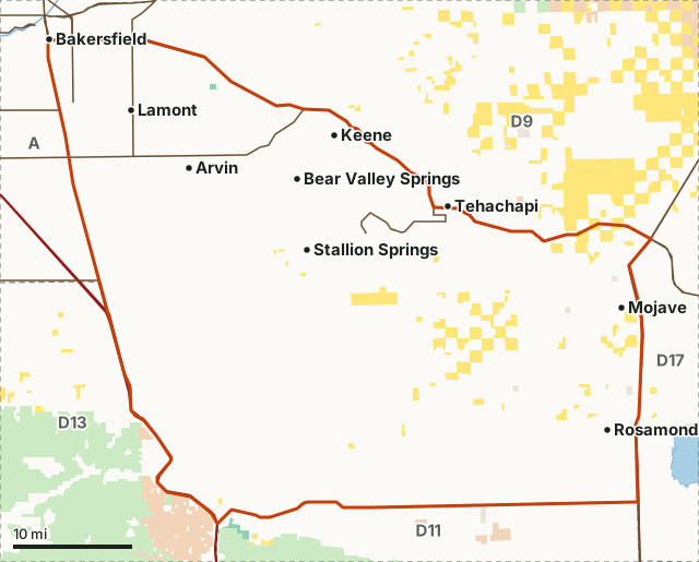
BLMCDFW landOther state or federal landZone D10Neighboring zonesLake or riverHighway
| CDFW region | Region 4, Central Region |
|---|---|
| Counties | Kern and Los Angeles |
| Size | 882,565 acres (1,379 square miles) |
| Public land | 2.4% (21,187 acres) |
| Tag quota, 2026 | 700 |
| Archery season, 2026 | August 15 to September 6 |
| General season, 2026 | September 26 to October 25 |
| Bag limit | One buck, forked horn or better, per tag. |
| Deer taken, 2025 | 241 (CDFW estimate) |
| Hunter success, 2025 | 36.9% (CDFW) |
| Towns in and near it | Arvin, Mojave, Rosamond, Bakersfield and Tehachapi |
How many deer are taken in Zone D10?
CDFW estimates 241 deer were taken in Zone D10 in 2025, up from 162 in 2024. Hunters reported 128 of them; CDFW adds an estimate for the 46.8% of tag holders who did not report.
| Year | Tag quota | Tags issued | Bucks reported | Does reported | Deer taken (CDFW estimate) | Hunter success (CDFW) | Tag holders who did not report |
|---|---|---|---|---|---|---|---|
| 2025 | 700 | not printed | 127 | 0 | 241 | 36.9% | 46.8% |
| 2024 | 700 | not printed | 96 | 0 | 162 | 23.5% | 40.7% |
| 2023 | 700 | not printed | 78 | 0 | 108 | 15.4% | 28.1% |
| 2022 | 700 | 696 | 117 | 0 | 170 | 24.4% | 31.5% |
| 2021 | 700 | 700 | 107 | 0 | 153 | 21.9% | 30.4% |
| 2020 | 700 | 697 | 132 | 0 | 179 | 25.7% | 26.4% |
Source: CDFW California Deer Harvest Statistics (2020 to 2025), Table 1. CDFW's hunter success is its estimated deer kill divided by tags issued. Harvest on Private Lands Management and Section 554 landowner programs is not included.
What size are the bucks taken in Zone D10?
Of the 127 bucks hunters reported with points recorded in 2025, 18 (14.2%) had 4 points or more and 39 had 3 points. CDFW counts antler points on one side.
| Year | Spike | 2 points | 3 points | 4 points | 5 points or more | Bucks with points recorded |
|---|---|---|---|---|---|---|
| 2025 | 0 (0%) | 70 (55.1%) | 39 (30.7%) | 14 (11%) | 4 (3.1%) | 127 |
| 2024 | 0 (0%) | 59 (61.5%) | 22 (22.9%) | 12 (12.5%) | 3 (3.1%) | 96 |
| 2023 | 0 (0%) | 43 (55.1%) | 23 (29.5%) | 12 (15.4%) | 0 (0%) | 78 |
Source: CDFW 2025 California Deer Harvest Statistics, Table 2 (reported deer kill by antler class), and the two years before it. Shares are of the bucks reported with points recorded.
When is deer season in Zone D10 in 2026?
Archery only: August 15 to September 6. General season: September 26 to October 25, 2026. CDFW's rule for the season: The season in Zone D-10 shall open on the fourth Saturday in September and extend for 30 consecutive days.
Source: CDFW Approved 2026 Deer Seasons and CDFW 2026-2027 California Mammal Hunting Regulations, page 45 (Title 14, Section 360). CDFW can change a season: check CDFW's deer zone page before you go.
How much public land is in Zone D10?
2.4% of Zone D10 is national forest, BLM or CDFW land: 21,187 of its 882,565 acres.
| Manager | Acres | Share of Zone D10 |
|---|---|---|
| BLM | 20,962 | 2.4% |
| Other state or federal land | 908 | 0.1% |
| CDFW land | 225 | under 0.1% |
Measured by FilledTag inside CDFW's zone boundary from California Protected Areas Database (CPAD) 2026a. "Public land" on this page means national forest, BLM and CDFW land, the three managers whose ground is open to hunting under their own rules. National Park Service land, state parks and most other public ground are listed but not counted: hunting there is closed or limited. Land held by cities, counties, districts and private groups is not shown.
Which elk and pronghorn zones overlap Zone D10?
Elk zones: Tehachapi elk zone (882,309 acres inside Zone D10). Elk and pronghorn tags are drawn in CDFW's big game drawing, apart from a few fundraising tags.
How do you get to Zone D10?
Numbered highways through it, longest stretch first: CA 58, CA 99, I-5, CA 138, CA 223 and CA 14. 20 Census places are inside it, among them Arvin, Mojave, Rosamond, Bear Valley Springs, Stallion Springs and Golden Hills. Nearby: Bakersfield (on the line), Tehachapi (on the line), Lancaster (6 miles) and Shafter (13 miles).
Which deer zones border Zone D10?
Zone D10 touches 5 other deer zones. Their size, public land and CDFW's 2025 numbers:
| Zone | Square miles | Public land | Deer taken, 2025 | Hunter success, 2025 |
|---|---|---|---|---|
| Zone A | 35,615 | 11.8% | 9,184 | 34.2% |
| Zone D9 | 1,457 | 47.7% | 342 | 17.1% |
| Zone D11 | 2,540 | 44.8% | 622 | 13.8% |
| Zone D13 | 1,305 | 60.4% | 372 | 13.7% |
| Zone D17 | 19,555 | 47.1% | 58 | 11.6% |
Questions hunters ask
How many deer tags are there for Zone D10?
CDFW's 2026 tag quota is 700. In 2025 the quota was 700 and CDFW estimates 241 deer were taken here.
What is the hunter success rate in Zone D10?
CDFW puts 2025 hunter success at 36.9%. CDFW works it out as its estimated deer kill divided by tags issued. In 2024 it was 23.5%.
When does deer season open in Zone D10 in 2026?
Archery season runs August 15 to September 6, 2026, and the general season September 26 to October 25. CDFW's rule: The season in Zone D-10 shall open on the fourth Saturday in September and extend for 30 consecutive days.
How much public land is in Zone D10?
2.4% of Zone D10, 21,187 acres, is national forest, BLM or CDFW land by CPAD 2026a.
CDFW's boundary of Zone D10
In those portions of Kern and Los Angeles counties within a line beginning at the intersection of Highways 99 and 58; southeast along Highway 58 to Highway 14; south along Highway 14 to Highway 138; west along Highway 138 to Interstate 5; north on Interstate 5 to Highway 99; north on Highway 99 to the point of beginning.
From CDFW 2026-2027 California Mammal Hunting Regulations, page 45, Title 14, Section 360.
Get a California hunt plan when they open
Hunt plans for California are coming. Join the list and you'll hear first. The first 50 hunters in each new state get their plan free.
Until then, the free FilledTag app for iPhone has a map that works in every state, California included.
Where these numbers come from
- Harvest, quotas, hunter success and antler classes: CDFW California Deer Harvest Statistics (2020 to 2025).
- 2026 seasons and quotas: CDFW Approved 2026 Deer Seasons; boundary, bag limit and season rule: CDFW 2026-2027 California Mammal Hunting Regulations.
- Public land: California Protected Areas Database (CPAD) 2026a. Zone boundary: CDFW deer hunt zones (BIOS ds342, Title 14 Section 360).
- Highways and towns: U.S. Census Bureau TIGER/Line 2024 primary and secondary roads; U.S. Census Bureau 2024 Gazetteer, places.
FilledTag is not part of the California Department of Fish and Wildlife. Numbers are copied from CDFW, CPAD and the Census Bureau, or measured from their maps; nothing on this page is estimated by FilledTag.
California hunting CDFW Region 4 Zone A Zone D9 Zone D11 Zone D13 Zone D17