Honey Lake Wildlife Area: hunting rules and map
Honey Lake Wildlife Area is 7,716 acres of CDFW land in Lassen County, in CDFW's Northern Region. Title 14, Section 551 lists it as Type B: hunter access is restricted in waterfowl season and a hunting pass is needed. It lies in deer Zone X6a, where CDFW estimates 247 deer were taken in 2025.
Data updated October 2026. Rules: CDFW's 2026-2027 land use regulations (updated July 1, 2026). Boundary and acres: CDFW. Zones: CDFW. Land around it: CPAD 2026a.
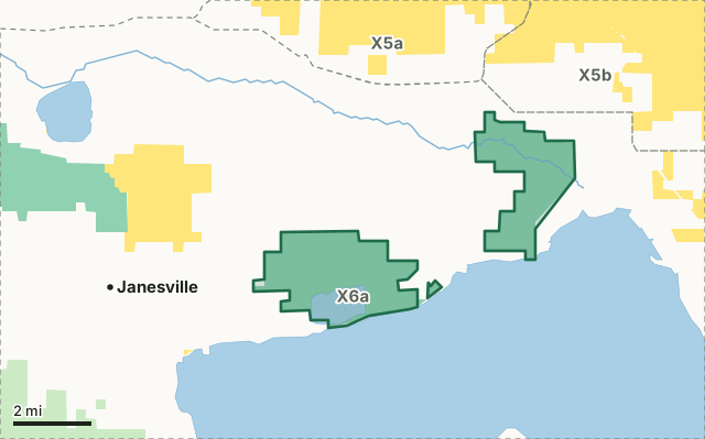
BLMCDFW landHoney Lake WADeer zone lineLake or riverHighway
| Size | 7,716 acres (CDFW boundary) |
|---|---|
| CDFW region | Region 1, Northern Region |
| County | Lassen |
| Wildlife area type | Type B |
| Closures | Closed to all public uses from September 16 until the opening of waterfowl season. |
| Camping | Allowed. |
| Deer zone | Zone X6a |
| Pronghorn zone | Pronghorn Zone 4 (Lassen) |
| Nearest towns | Janesville (4 mi), Litchfield (4 mi) and Milford (10 mi) |
What are CDFW's rules for Honey Lake Wildlife Area?
As a Type B area, Honey Lake WA needs a Type A or Type B season hunting pass in waterfowl season, with set shoot days (Section 551(e)).
| Rule | Unit | CDFW's words |
|---|---|---|
| Camping | Fleming and Dakin Units | Allowed. |
| Closures and restrictions | Fleming and Dakin Units | Closed to all public uses from September 16 until the opening of waterfowl season. During the waterfowl and pheasant hunt seasons, the wildlife area is closed to all public use with the exception of Saturdays, Sundays, and Wednesdays for hunting only. |
| Additional hunting: Quail and rabbit | Whole area | Allowed only on waterfowl shoot days that occur during the pheasant season. |
| Lands pass | Whole area | Listed in section 551(w): a visitor must carry a valid Lands Pass, or a valid hunting or fishing license, to enter. |
Source: CDFW 2026-2027 Waterfowl, Upland Game, and Public Use of Department Lands Regulations, Title 14, Section 551. CDFW's page for Honey Lake Wildlife Area has maps and contacts. Deer, elk and pronghorn hunting also follow the zone's own season and tag.
What does CDFW say about Honey Lake Wildlife Area?
Honey Lake Wildlife Area is approximately 7,600 acres of sagebrush habitat surrounding a shallow lake in the Great Basin Desert. Alkali-tolerant vegetation lines the banks. This wetland supports many migratory birds including tundra swans. There are excellent opportunities to see hundreds of migratory and nesting waterfowl, birds of prey, and passerines, sandhill cranes, beavers, pronghorn antelope, and deer. The area includes the Dakin and Fleming Units.
On hunting, CDFW's page says: Rabbits, waterfowl, coots, moorhens, snipe, pheasants, quail, and dove may be present.
CDFW lists small game and upland game birds hunting for the area, and also wildlife viewing.
From CDFW's page for Honey Lake Wildlife Area, read October 2026.
Which hunt zones is Honey Lake Wildlife Area in?
CDFW's numbers for each zone are for the whole zone, not the wildlife area alone.
| Zone | Acres of Honey Lake WA in it | CDFW's latest numbers for the zone |
|---|---|---|
| Deer Zone X6a | 7,716 | 247 deer taken in 2025, 77.2% hunter success; 2026 general season October 3 to 18 |
| Pronghorn Zone 4 (Lassen) | 7,716 | 65 pronghorn taken in 2023 |
CDFW deer hunts whose ground includes part of Honey Lake WA: hunt A-11 (Zone X-6a Archery Hunt), hunt A-26 (Bass Hill Archery Buck Hunt) and hunt M-8 (Bass Hill Muzzleloading Rifle Buck Hunt).
Harvest: CDFW California Deer Harvest Statistics (2020 to 2025); CDFW Pronghorn Hunt Statistics. Acres measured by FilledTag from CDFW's boundaries.
What public land is around Honey Lake Wildlife Area?
Within 4 miles of its boundary, CPAD 2026a maps 15,610 acres of BLM land and 7,844 acres of CDFW land.
How do you get to Honey Lake Wildlife Area?
CDFW's directions: From Susanville, proceed east on Highway 395 approximately 20 miles; at Mapes Road turn right, and proceed 3 miles to DFG Road; turn east for 1.5 miles to CDFW office.
CDFW's location note: About 20 miles east of Susanville. Nearest towns: Janesville (4 miles), Litchfield (4 miles), Milford (10 miles) and Johnstonville (10 miles).
Questions hunters ask
Can you hunt on Honey Lake Wildlife Area?
Yes. Section 551 lists it as Type B. CDFW's closure: Closed to all public uses from September 16 until the opening of waterfowl season. During the waterfowl and pheasant hunt seasons, the wildlife area is closed to all public use with the exception of Saturdays, Sundays, and Wednesdays for hunting only.
Can you camp on Honey Lake Wildlife Area?
CDFW's rule: Allowed. Where camping is allowed, a visitor may stay up to seven nights in a row and fourteen nights a year (Section 550(p)).
Which deer zone is Honey Lake Wildlife Area in?
All of it is in deer Zone X6a, by CDFW's boundaries. CDFW estimates 247 deer were taken in Zone X6a in 2025, across the whole zone.
What is the closest town to Honey Lake Wildlife Area?
Janesville (4 miles), Litchfield (4 miles) and Milford (10 miles), by the Census Bureau's places.
Get a California hunt plan when they open
Hunt plans for California are coming. Join the list and you'll hear first. The first 50 hunters in each new state get their plan free.
Until then, the free FilledTag app for iPhone has a map that works in every state, California included.
Where these facts come from
- Rules: CDFW 2026-2027 Waterfowl, Upland Game, and Public Use of Department Lands Regulations.
- Boundary and acres: CDFW public access lands (BIOS ds3077); CDFW, Honey Lake Wildlife Area.
- Zones: CDFW BIOS zone layers. Surrounding public land: California Protected Areas Database (CPAD) 2026a.
- Deer harvest: CDFW California Deer Harvest Statistics (2020 to 2025).
FilledTag is not part of the California Department of Fish and Wildlife.