Pronghorn Zone 3, Likely Tables: California pronghorn hunting by the numbers
Pronghorn Zone 3 (Likely Tables) covers 2,271 square miles of Modoc and Lassen counties. 64.6% is national forest, BLM or CDFW land (CPAD 2026a). CDFW's 2026 regulations list 1 hunt here with 5 tags in all. In 2023, CDFW's pronghorn hunt statistics show 22 pronghorn taken on 70 tags, with 5,322 applications for this zone's hunts.
Data updated October 2026. Hunt statistics: CDFW, 2018 to 2023. 2026 hunts and tags: CDFW's 2026-2027 regulations. Land: CPAD 2026a.
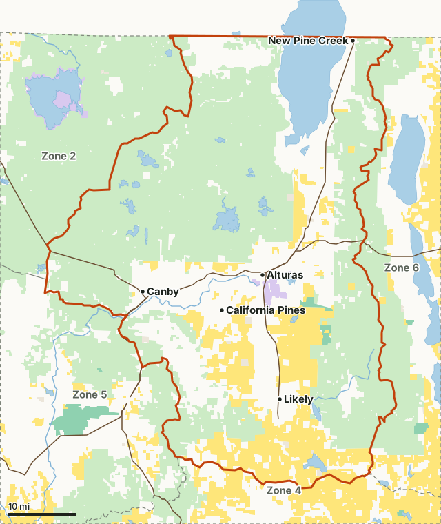
National forestBLMCDFW landNational wildlife refugeOther state or federal landZone 3Neighboring zonesLake or riverHighway
| CDFW region | Region 1, Northern Region |
|---|---|
| Counties | Modoc and Lassen |
| Size | 1,453,739 acres (2,271 square miles) |
| Public land | 64.6% (938,915 acres) |
| Hunts and tags, 2026 | 1 hunt, 5 tags |
| Taken, 2023 | 22 on 70 tags (CDFW) |
| Applications, 2023 | 5,322 for this zone's hunts |
| Towns in and near it | Alturas, California Pines, Canby, Madeline and Fort Bidwell |
What pronghorn hunts are in Zone 3 in 2026?
CDFW's 2026-2027 regulations list 1 hunt for this zone, 5 tags in all:
| Hunt | Type | 2026 tags | 2026 dates |
|---|---|---|---|
| Zone 3 Likely Tables Period 1 General Methods Buck | General Methods | 5 | August 22 to 30 |
Source: CDFW 2026-2027 California Mammal Hunting Regulations, page 94.
In CDFW's 2026 Big Game Drawing, 2,761 applications went to this zone's hunts:
| Hunt code | Hunt | Tags | By preference points | Applicants |
|---|---|---|---|---|
| 730 | Zone 3 - Likely Tables Period 1 - General Methods - Buck | 5 | 4 | 2,761 |
Source: CDFW 2026 Big Game Drawing statistics. The rest of each quota goes by draw-by-choice. CDFW also prints applicants at each point level.
How many pronghorn are taken in Zone 3?
In 2023, CDFW's pronghorn hunt statistics show 22 taken on 70 tags; 61 tag holders reported. Year by year, for this zone's hunts:
| Year | Hunts | Tags | Applications | Tag holders who reported | Taken |
|---|---|---|---|---|---|
| 2023 | 4 | 70 | 5,322 | 61 | 22 |
| 2022 | 4 | 70 | 5,716 | 66 | 30 |
| 2021 | 4 | 70 | 6,110 | 43 | 25 |
| 2020 | 4 | 90 | not printed | 91 | 51 |
| 2019 | 4 | 110 | 6,454 | 107 | 56 |
| 2018 | 4 | 110 | 6,072 | 108 | 85 |
Each hunt in 2023:
| Hunt code | Hunt | Applications | Tags | Taken | Success (CDFW) |
|---|---|---|---|---|---|
| 730 | Zone 3 - Likely Tables Period 1 - General Methods - Buck | 2,964 | 25 | 9 | 36% |
| 732 | Zone 3 - Likely Tables Period 2 - General Methods - Buck | 1,693 | 25 | 11 | 44% |
| 734 | Zone 3 - Likely Tables Apprentice - General Methods - Either-sex | 325 | 5 | 1 | 20% |
| 738 | Zone 3 - Likely Tables - Archery only - Buck | 340 | 15 | 1 | 7% |
Source: CDFW Pronghorn Hunt Statistics (2018 to 2023); 2023: CDFW 2023 Pronghorn Hunt Statistics. CDFW's success rate is reported harvest divided by tags. Applications are the sum of the applicant counts CDFW prints for each of this zone's hunts. CDFW's 2020 pronghorn applicant counts do not line up with its rows and are left out.
How much public land is in Zone 3?
64.6% of the zone, 938,915 of 1,453,739 acres, is national forest, BLM or CDFW land. The largest public units: Modoc National Forest (740,040 acres) and Modoc National Wildlife Refuge (6,955 acres).
| Manager | Acres | Share of the zone |
|---|---|---|
| National forest | 740,040 | 50.9% |
| BLM | 194,644 | 13.4% |
| National wildlife refuge | 6,955 | 0.5% |
| Other state or federal land | 4,269 | 0.3% |
| CDFW land | 4,231 | 0.3% |
Measured by FilledTag inside CDFW's zone boundary from California Protected Areas Database (CPAD) 2026a. "Public land" on this page means national forest, BLM and CDFW land, the three managers whose ground is open to hunting under their own rules. National Park Service land, state parks and most other public ground are listed but not counted: hunting there is closed or limited. Land held by cities, counties, districts and private groups is not shown.
CDFW lands in the zone: Fitzhugh Creek Wildlife Area (2,135 acres) and Pine Creek Wildlife Area (2,011 acres).
Which deer zones overlap Zone 3?
Zone X2 (628,942 acres; 78 deer taken in 2025), Zone X3b (464,710 acres; 161 deer taken in 2025) and Zone X3a (360,071 acres; 209 deer taken in 2025). Elk zones that overlap it: Northeastern elk zone.
How do you get to Zone 3?
Numbered highways through it, longest stretch first: US 395, CA 299 and CA 139. Towns inside: Alturas, California Pines, Canby, New Pine Creek, Likely and Daphnedale Park. Nearby: Madeline (on the line), Fort Bidwell (3 miles), Lake City (3 miles) and Cedarville (5 miles).
Neighboring pronghorn zones: Pronghorn Zone 2 (Clear Lake), Pronghorn Zone 4 (Lassen), Pronghorn Zone 5 (Big Valley) and Pronghorn Zone 6 (Surprise Valley).
Questions hunters ask
How many pronghorn tags are there in Zone 3?
CDFW's 2026 regulations list 5 tags in 1 hunt: Zone 3 Likely Tables Period 1 General Methods Buck (5). Tags are drawn in CDFW's big game drawing, apart from a few fundraising tags.
How many pronghorn were taken in Zone 3?
CDFW's 2023 pronghorn hunt statistics show 22 taken on 70 tags across 4 hunts. In 2022: 30 on 70 tags.
When are the Zone 3 pronghorn hunts in 2026?
August 22 to 30, by hunt, in CDFW's 2026 regulations.
How much public land is in Zone 3?
64.6%: 938,915 acres of national forest, BLM and CDFW land by CPAD 2026a. The largest public units: Modoc National Forest (740,040 acres) and Modoc National Wildlife Refuge (6,955 acres).
CDFW's boundary of Zone 3
Those portions of Modoc and Lassen counties within a line beginning at the junction of the Crowder Flat Road and the California-Oregon state line; east along the California-Oregon state line to the crest of the Warner Mountains; south along the crest of the Warner Mountains to the Summit Trail at Pepperdine Camp; south along the Summit Trail to the South Warner Road near Patterson Forest Service Station; west along the South Warner Road to Long Valley-Clarks Valley Road; south on Long Valley-Clarks Valley Road to Clarks Valley-Madeline Road; west on Clarks Valley-Madeline Road to Highway 395 at the town of Madeline; north on Highway 395 to Madeline-Adin Road; northwest on Madeline-Adin Road to Hunsinger Draw-Sweagert Flat Road; east and north on Hunsinger Draw-Sweagert Flat Road to Sweagert Flat-Hunters Ridge Road; north and west on Sweagert Flat-Hunters Ridge Road to Highway 299 near Lower Rush Creek Recreation Site; north on Highway 299 to Canby Bridge-Cottonwood Flat Road; northwest on Canby Bridge-Cottonwood Flat Road to Cottonwood Flat-Happy Camp Road; northwest on Cottonwood Flat-Happy Camp Road to Modoc County Road 91; north on Modoc County Road 91 to Highway 139; north on Highway 139 to on Hackamore-Sorholus Tank Road; northeast on Hackamore-Sorholus Tank Road to Browns Well-Badger Well Road; north on Browns Well-Badger Well Road to Badger Well-Deadhorse Flat Road; northeast and east on Badger Well-Deadhorse Flat Road to Mowitz-Blue Mountain Road; north and east on Mowitz-Blue Mountain Road to Modoc County Road 136; east on Modoc County Road 136 to Modoc County Road 73; north on Modoc County Road 73 to Crowder Flat Road; north on Crowder Flat Road to the California-Oregon state line, to the point of beginning.
From CDFW 2026-2027 California Mammal Hunting Regulations, Title 14, Section 363.
Get a California hunt plan when they open
Hunt plans for California are coming. Join the list and you'll hear first. The first 50 hunters in each new state get their plan free.
Until then, the free FilledTag app for iPhone has a map that works in every state, California included.
Where these numbers come from
- Hunt statistics: CDFW Pronghorn Hunt Statistics, 2018 to 2023.
- 2026 hunts, tags and dates: CDFW 2026-2027 California Mammal Hunting Regulations.
- Public land: California Protected Areas Database (CPAD) 2026a. Zone boundary: CDFW pronghorn hunt zones (BIOS ds787).
- Highways and towns: U.S. Census Bureau TIGER/Line 2024 primary and secondary roads; U.S. Census Bureau 2024 Gazetteer, places.
FilledTag is not part of the California Department of Fish and Wildlife. Numbers are copied from CDFW, CPAD and the Census Bureau, or measured from their maps; nothing on this page is estimated by FilledTag.
California hunting CDFW Region 1 Pronghorn Zone 2 (Clear Lake) Pronghorn Zone 4 (Lassen) Pronghorn Zone 5 (Big Valley) Pronghorn Zone 6 (Surprise Valley)