Lamar County deer harvest: Georgia Game Check, 2016-17 to 2025-26
Hunters reported 785 deer in Lamar County in the 2025-26 season through Georgia Game Check: 400 bucks and 385 does (WRD). That is 4.3 deer per square mile of land, and 116th of Georgia's 159 counties by total. The count was 21% below 2024-25 (994).
Data updated October 2026. Harvest: WRD Game Check reports to the 2025-26 season. Seasons: WRD's 2026-27 regulations.
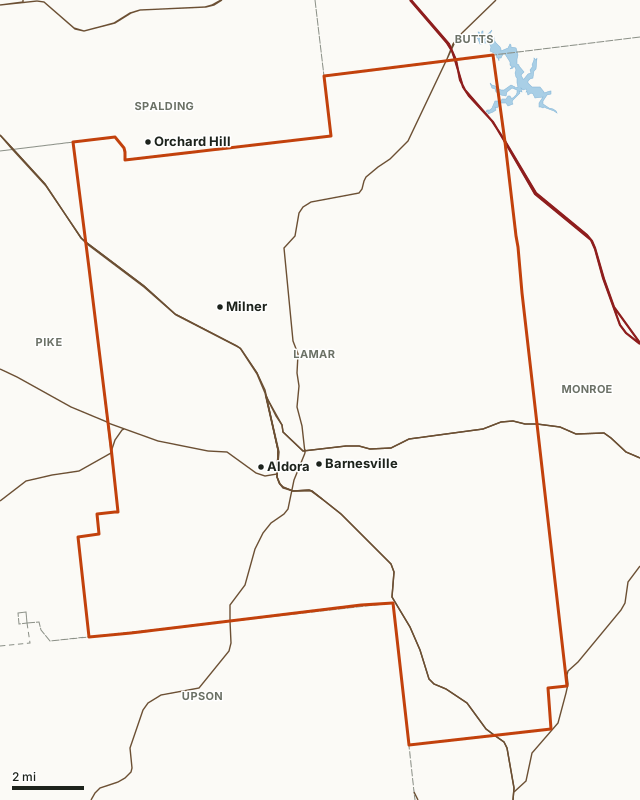
Lamar CountyLake or riverHighwayCounty line
| Deer reported, 2025-26 | 785 (400 bucks, 385 does) |
|---|---|
| Per square mile of land | 4.3, 62nd of 159 |
| Average, 10 seasons | 866 deer a season |
| Highest season | 1,000 in 2023-24 |
| Private-land deer zone | Green (WRD) |
| WRD region | Region 3 |
| Land area | 183.5 square miles (Census) |
| Public land mapped here | No WRD WMA |
| Towns | Barnesville, Milner and Aldora |
How many deer are killed in Lamar County each season?
WRD has reported Lamar County's deer for 10 seasons. The average was 866 a season; the most was 1,000 in 2023-24 and the fewest 785 in 2025-26. 2025-26 was 4% below 2016-17.
| Season | Deer reported | Bucks | Does | Per square mile | WRD's adjusted total |
|---|---|---|---|---|---|
| 2025-26 | 785 | 400 | 385 | 4.3 | 1,053 |
| 2024-25 | 994 | 505 | 489 | 5.4 | 1,362 |
| 2023-24 | 1,000 | 505 | 495 | 5.4 | 1,204 |
| 2022-23 | 861 | 475 | 386 | 4.7 | 1,156 |
| 2021-22 | 852 | 467 | 385 | 4.6 | 1,137 |
| 2020-21 | 804 | 450 | 354 | 4.4 | 1,041 |
| 2019-20 | 818 | 435 | 383 | 4.5 | 1,158 |
| 2018-19 | 869 | 450 | 419 | 4.7 | 1,230 |
| 2017-18 | 859 | 509 | 350 | 4.7 | 1,202 |
| 2016-17 | 814 | 465 | 349 | 4.4 | 1,101 |
Source: WRD deer harvest reports (Georgia Game Check), deer reported by county. Per square mile uses the county's 183.5 square miles of land (Census). "Adjusted total" is WRD's own figure in the same layer, which allows for deer not reported through Game Check; the reporting rates WRD applies to Lamar County for 2025-26 are 80% of bucks and 70% of does.
When is deer season in Lamar County in 2026-27?
On private land Lamar County is in WRD's Green zone. These are the zone's 2026-27 dates.
| Weapon | Dates | What may be taken |
|---|---|---|
| Archery | Sept. 12 to Oct. 9, 2026 | Either sex |
| Primitive weapons | Oct. 10 to 16, 2026 | Either sex |
| Firearms | Oct. 3 to 4, 2026 | Antlerless only |
| Firearms | Oct. 17, 2026 to Jan. 10, 2027 | Either sex |
Source: 2026-2027 Georgia Hunting and Fishing Regulations, pages 12 to 13; county zones: WRD county deer, bear and alligator zones.
Where is the public hunting land in Lamar County?
No WRD WMA boundary falls in Lamar County. The closest WMAs with a page here: Rum Creek WMA (about 22 miles), Joe Kurz WMA (about 23 miles) and Sprewell Bluff WMA (about 26 miles).
Acres measured by FilledTag on WRD WMA boundaries, U.S. Forest Service national forest ownership and U.S. Fish and Wildlife Service refuge boundaries.
How does Lamar County compare with its neighbors?
Lamar County touches 5 Georgia counties. Their 2025-26 harvest, and the change since 2016-17:
| County | Deer reported, 2025-26 | Per square mile | Change since 2016-17 |
|---|---|---|---|
| Lamar County | 785 | 4.3 | -4% |
| Butts County | 645 | 3.5 | 9% |
| Monroe County | 1,340 | 3.4 | -8% |
| Pike County | 1,298 | 6 | 9% |
| Spalding County | 789 | 4 | 13% |
| Upson County | 1,662 | 5.1 | -4% |
Questions hunters ask
How many deer were killed in Lamar County, Georgia last season?
785 deer were reported through Georgia Game Check in Lamar County in the 2025-26 season: 400 bucks and 385 does, by WRD's harvest reports.
What deer zone is Lamar County in?
Lamar County is in WRD's Green zone for private land in 2026-27. Firearms either-sex days in the zone: Oct. 17, 2026 to Jan. 10, 2027. Source: WRD regulations, pages 12 to 13.
Is there public hunting land in Lamar County?
No WRD WMA boundary falls in Lamar County. The closest WMAs with a page here: Rum Creek WMA (about 22 miles), Joe Kurz WMA (about 23 miles) and Sprewell Bluff WMA (about 26 miles).
Has the deer harvest in Lamar County gone up or down?
From 814 in 2016-17 to 785 in 2025-26, 4% lower. The high in that span was 1,000 (2023-24) and the low 785 (2025-26).
Get a Georgia hunt plan when they open
Hunt plans for Georgia are coming. Join the list and you'll hear first. The first 50 hunters in each new state get their plan free.
Until then, the free FilledTag app for iPhone has a map that works in every state, Georgia included.
Where these numbers come from
- Deer harvest, adjusted totals and reporting rates: WRD deer harvest reports (Georgia Game Check); Georgia Game Check results.
- Deer zones and dates: 2026-2027 Georgia Hunting and Fishing Regulations, pages 12 to 13; WRD county deer, bear and alligator zones.
- Public land: WRD WMA boundaries; U.S. Forest Service national forest ownership; U.S. Fish and Wildlife Service refuge boundaries. County land area: U.S. Census Bureau 2024 county boundaries. Highways and towns: U.S. Census Bureau TIGER/Line 2024 roads; U.S. Census Bureau 2024 Gazetteer.
FilledTag is not part of Georgia DNR. Numbers are copied from WRD and the Census Bureau or measured from public maps; nothing here is estimated by FilledTag.
Georgia hunting Georgia deer harvest by county Butts County Monroe County Pike County Spalding County