Chestatee WMA: 2026-27 seasons and deer harvest
Chestatee WMA is 27,123 acres of public hunting land in Lumpkin and White counties, managed by Georgia DNR's WRD (Region 2). For 2026-27, WRD lists these deer dates: archery, Buck Only: Sept. 12 to 25, Oct. 12 to 29; firearms, Buck Only: Nov. 18 to Nov. 21, Dec. 26 to Jan. 1; Bonus Buck Only: Dec. 9 to 12. Hunters reported 6 deer on the area in the 2025-26 season through Georgia Game Check (6 bucks, 0 does).
Data updated October 2026. Seasons: WRD's 2026-27 WMA listings. Harvest: WRD Game Check reports to the 2025-26 season. Quota hunts: WRD's 2026 lottery reports.
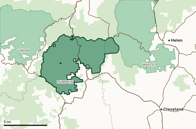
Chestatee WMAOther WRD WMAsNational forestLake or riverHighwayCounty line
| Size | 27,123 acres (WRD's 2026-27 regulations, page 36) |
|---|---|
| County | Lumpkin County, White County, Union County |
| WRD region | Region 2, office 770-535-5700 |
| WRD's listing | WMA on leased or partner land |
| Deer, 2026-27 | Archery: Buck Only: Sept. 12 to 25, Oct. 12 to 29. Firearms: Buck Only: Nov. 18 to Nov. 21, Dec. 26 to Jan. 1; Bonus Buck Only: Dec. 9 to 12 |
| Deer reported, 2025-26 | 6 (6 bucks, 0 does) |
| Camping | Allowed (WRD) |
| Nearest towns | Helen (6 mi), Dahlonega (8 mi) and Cleveland (8 mi) |
What is Chestatee WMA like?
Chestatee Wildlife Management Area is located in Lumpkin and White counties. This 27,124-acre property has hunting opportunities for deer, bear, turkey and small game. This property is owned by the U.S. Forest Service who manages all non-hunting aspects of their property such as roads, recreation and land management. Vehicle Usage: ATVs and UTVs are not allowed on U.S. Forest Service roads. They may only be used on roads/trails designated specifically for their use. For more information, visit https://www.fs.usda.gov/detail/conf/home/?cid=fseprd1154774 . Check Road Closures: Road closures due to damage or weather-related conditions for this property will be listed at https://www.fs.usda.gov/main/conf/ .
WRD lists these facilities: hiking trails, lake, picnic sites and primitive campsites.
From WRD's page for Chestatee WMA.
Nearly all of the area lies on national forest land, measured on the U.S. Forest Service map. On national forest land the Forest Service runs the roads and campgrounds; WRD runs the hunting.
When are the 2026-27 seasons on Chestatee WMA?
WRD sets each WMA's own dates. These are WRD's 2026-27 dates and notes for the area, as printed:
| Season | 2026-27 dates and WRD's notes |
|---|---|
| Deer and bear, archery | Buck Only: Sept. 12 to 25, Oct. 12 to 29 |
| Deer and bear, firearms | Buck Only: Nov. 18 to Nov. 21, Dec. 26 to Jan. 1 Bonus Buck Only: Dec. 9 to 12 |
| Bear, firearms | Sept. 26 to Oct. 2 |
| Turkey | Apr. 3 to May 15 |
| Coyote | May 16 to 31. Feral hogs may be hunted with dogs. |
| Small Game | State Seasons |
Source: WRD WMA hunting opportunities, 2026-27 season (FY27). The area's full listing in the 2026-2027 Georgia Hunting and Fishing Regulations, page 36 adds its quota, youth and special hunts and its area notes, and is the final word. WRD can change a hunt during the year: check WRD's page for the area before you go.
How many deer are taken on Chestatee WMA?
Hunters reported 6 deer on Chestatee WMA in the 2025-26 season: 6 bucks and 0 does. Over the 10 seasons WRD reports, the area averaged 3 deer a season, from 2 in 2024-25 to 6 in 2025-26.
| Season | Deer reported | Bucks | Does | Bucks per 100 deer |
|---|---|---|---|---|
| 2025-26 | 6 | 6 | 0 | 100 |
| 2024-25 | 2 | 2 | 0 | 100 |
| 2023-24 | 5 | 5 | 0 | 100 |
| 2022-23 | 2 | 2 | 0 | 100 |
| 2021-22 | 2 | 2 | 0 | 100 |
| 2020-21 | 3 | 3 | 0 | 100 |
| 2019-20 | 3 | 3 | 0 | 100 |
| 2018-19 | 4 | 3 | 1 | 75 |
| 2017-18 | 5 | 5 | 0 | 100 |
| 2016-17 | 2 | 2 | 0 | 100 |
Source: WRD deer harvest reports (Georgia Game Check), deer reported by WMA. Deer from bonus hunts are tagged at the check station and may not be in Game Check's count. WRD records the 2026-27 season as it goes; it is left out until it ends.
Which county is Chestatee WMA in?
Chestatee WMA spreads over 3 counties. Each county's deer harvest for 2025-26, for the whole county, private land included:
| County | WMA acres in it | County deer reported, 2025-26 | Deer per square mile | Rank of 159 |
|---|---|---|---|---|
| Lumpkin County | 20,225 | 1,172 | 4.1 | 80th |
| White County | 1,523 | 1,092 | 4.5 | 91st |
| Union County | 28 | 1,755 | 5.4 | 37th |
County harvest: WRD deer harvest reports (Georgia Game Check). WMA acres in each county measured by FilledTag on WRD's boundary map and the U.S. Census Bureau 2024 county boundaries; the mapped boundary can take in water or tracts that WRD's stated acreage leaves out.
How do you get to Chestatee WMA?
WRD gives this address: 955 Dicks Creek Road, Dahlonega, GA 30533 (GPS 34.66494, -83.9195). Highways through the area: GA 11, US 129, US 19 and GA 60. Nearest towns: Helen (6 miles), Dahlonega (8 miles), Cleveland (8 miles) and Blairsville (9 miles).
Besides hunting, WRD lists hiking, lake & river fishing, primitive camping and wildlife viewing here.
The closest other WMAs with a page here: Chattahoochee WMA (next to it), Coopers Creek WMA (next to it), Blue Ridge WMA (6 miles) and Swallow Creek WMA (7.7 miles).
Questions hunters ask
When is deer season on Chestatee WMA in 2026-27?
WRD lists these 2026-27 deer dates for Chestatee WMA: archery, Buck Only: Sept. 12 to 25, Oct. 12 to 29; firearms, Buck Only: Nov. 18 to Nov. 21, Dec. 26 to Jan. 1; Bonus Buck Only: Dec. 9 to 12. WMA dates can differ from the statewide dates, and sign-in is required for deer hunts unless WRD's listing says otherwise.
When is turkey season on Chestatee WMA?
WRD's 2026-27 listing for Chestatee WMA gives turkey: Apr. 3 to May 15. On a WMA the limit is one gobbler a season per area.
How many deer were killed on Chestatee WMA last season?
6 deer were reported on Chestatee WMA in the 2025-26 season, 6 bucks and 0 does, by WRD's Game Check reports by WMA.
Can you camp on Chestatee WMA?
Yes. WRD's listing for Chestatee WMA allows camping, with primitive campsites. Follow the area's posted rules.
What county is Chestatee WMA in?
Lumpkin County (20,225 acres), White County (1,523 acres) and Union County (28 acres), measured on WRD's boundary.
Get a Georgia hunt plan when they open
Hunt plans for Georgia are coming. Join the list and you'll hear first. The first 50 hunters in each new state get their plan free.
Until then, the free FilledTag app for iPhone has a map that works in every state, Georgia included.
Where these numbers come from
- Seasons and notes: WRD WMA hunting opportunities, 2026-27 season (FY27); general WMA rules: 2026-2027 Georgia Hunting and Fishing Regulations, pages 19 to 21.
- Deer harvest by WMA and county: WRD deer harvest reports (Georgia Game Check).
- Quota hunts: WRD quota hunt lottery reports, 2026.
- Area description, facilities and address: WRD, Chestatee WMA. Boundary and acres: WRD WMA boundaries.
- Counties, highways and towns: U.S. Census Bureau 2024 county boundaries; U.S. Census Bureau TIGER/Line 2024 roads; U.S. Census Bureau 2024 Gazetteer. National forest and refuges: U.S. Forest Service national forest ownership; U.S. Fish and Wildlife Service refuge boundaries.
FilledTag is not part of Georgia DNR. Numbers are copied from WRD or measured from public maps; nothing on this page is estimated by FilledTag.
Georgia hunting All Georgia WMAs Lumpkin County deer harvest White County deer harvest Union County deer harvest