Mt. Vernon Game Propagation Center: hunting and access
IDNR's records mark 653 acres of Mt. Vernon Game Propagation Center open to hunting in Jefferson County, 2 miles from Bonnie. Deer archery: open at the site. Hunters took 5,124 deer in Jefferson County in 2025-26.
Data updated October 2026. Area facts: IDNR's IDNR hunting site data, read 2026-10. Harvest: IDNR county summaries, 2021-22 to 2025-26.
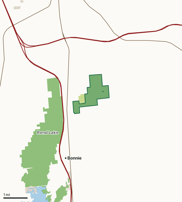
IDNR sites open to huntingOther IDNR and state landForest preserves, county and city landLand trusts and other open landMt. Vernon Game Propagation CenterCounty lineLakeHighway
| Size | 653 acres |
|---|---|
| County | Jefferson County |
| Deer harvest unit | Jefferson County |
| IDNR lists for hunting | Deer, Turkey, Squirrel, Rabbit and Dove |
| Deer, archery (IDNR) | open at the site |
| Turkey, spring (IDNR) | special hunt permit from Springfield |
| Turkey, fall archery (IDNR) | open at the site |
| Site type (IDNR) | state fish and wildlife area |
| IDNR region | 5 |
| Nearest towns | Bonnie (2 mi), Opdyke (4 mi) and Mount Vernon (5 mi) |
What can you hunt on Mt. Vernon Game Propagation Center?
IDNR's records list deer (archery), turkey (spring and fall archery), squirrel, rabbit and dove for Mt. Vernon Game Propagation Center.
What are the rules on Mt. Vernon Game Propagation Center?
How each season is hunted here, by IDNR's land records: open at the site for deer archery and turkey fall archery; special hunt permit from Springfield for turkey spring.
Site-specific rules are in IDNR's Hunting Digest and the site's hunter fact sheet; IDNR's public hunting areas list has the site's permit details.
How many deer are taken around Mt. Vernon Game Propagation Center?
Mt. Vernon Game Propagation Center lies in Jefferson County. Hunters took 5,124 deer in Jefferson County in 2025-26, against 4,834 in 2024-25.
| County | Mt. Vernon Game Propagation Center acres in it | Deer, 2025 | Deer, 2024 | Deer, 2023 |
|---|---|---|---|---|
| Jefferson County | 653 | 5,124 | 4,834 | 4,247 |
Harvest for the whole county, not the hunting site alone: IDNR white-tailed deer county summaries (2021-22 to 2025-26 seasons).
How do you get to Mt. Vernon Game Propagation Center?
Nearest towns: Bonnie (2 miles), Opdyke (4 miles), Mount Vernon (5 miles) and Nason (5 miles). Highways within 5 miles: I-57, I-64, IL 37, IL 148 and IL 142.
What other public land is near Mt. Vernon Game Propagation Center?
IDNR hunting sites within 10 miles:
- Rend Lake State Fish and Wildlife Area: 9,373 acres, next to it
- Ten Mile Creek State Fish and Wildlife Area: 6,979 acres, 3.9 miles away
- Wayne Fitzgerrell State Recreation Area: 1,597 acres, 6.2 miles away
Public land within 3 miles of Mt. Vernon Game Propagation Center
Counting Mt. Vernon Game Propagation Center itself, 3,103 of the 28,564 acres within 3 miles of its boundary are public land open to the public (10.9%), by USGS PAD-US 4.1 and IDNR's hunting area records.
| Manager | Acres within 3 miles |
|---|---|
| IDNR sites open to hunting | 3,012 |
| Other IDNR and state land | 65 |
| Land trusts and other open land | 24 |
| Forest preserves, county and city land | 2 |
Questions hunters ask
Where is Mt. Vernon Game Propagation Center?
In Jefferson County, 2 miles from Bonnie.
Can you deer hunt on Mt. Vernon Game Propagation Center?
By IDNR's records: archery, open at the site.
How much public land is around Mt. Vernon Game Propagation Center?
3,103 acres within 3 miles of its boundary, Mt. Vernon Game Propagation Center included, by USGS PAD-US 4.1 and IDNR's hunting area records. The closest other IDNR hunting site is Rend Lake State Fish and Wildlife Area (next to it).
Get a Illinois hunt plan when they open
Hunt plans for Illinois are coming. Join the list and you'll hear first. The first 50 hunters in each new state get their plan free.
Until then, the free FilledTag app for iPhone has a map that works in every state, Illinois included.
Where these facts come from
- Area description, species, rules and directions: IDNR land records: sites and hunting areas (OMLP, Prairie Research Institute).
- Boundary and acres: IDNR's map layer above. Surrounding public land: USGS PAD-US 4.1 (fee land open to the public) and IDNR's hunting area records.
- Deer harvest: IDNR white-tailed deer county summaries (2021-22 to 2025-26 seasons).
FilledTag is not part of the Illinois Department of Natural Resources. Check IDNR's rules and posted signs before you go.