Webster Wildlife Area: hunting, rules and access
Webster Wildlife Area is 9,709 acres by KDWP's count, centered about 7 miles northeast of Damar, in Rooks County and deer Unit 3. Camping: yes, in designated areas; equipment: NA (KDWP 2026-27). 4 managed dove fields for 2026.
Data updated October 2026. KDWP's Fall 2026-Spring 2027 summary and 2026 dove fields; KDWP GIS; WIHA 2026-27.
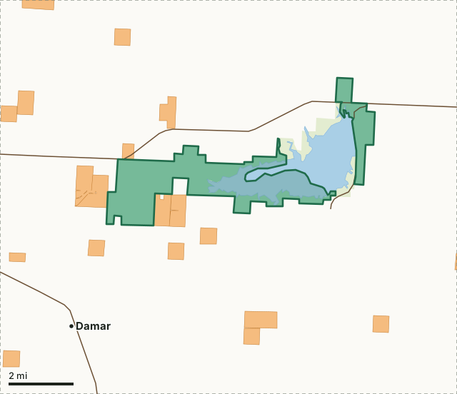
KDWP landState park or recreation areaWalk-in (WIHA)Webster Wildlife AreaOther wildlife areasDeer unit lineLakeHighway
| Acres | 9,709 (KDWP); 6,294 inside the mapped boundary, water included |
|---|---|
| Location (KDWP) | 9 mi. W of Stockton |
| Phone | (785) 425-6775 |
| Camping | Yes, in designated areas |
| Boating | Yes |
| Equipment restrictions | NA |
| Daily check-in/check-out | Not listed for this area |
| County | Rooks |
| Deer unit | Unit 3 |
| Managed dove fields, 2026 | 4 (4 acres) |
What are the rules on Webster Wildlife Area?
KDWP's 2026-27 listing puts no equipment restriction on the area. Its other rules:
- Handicapped hunting access area by permit; phone (785) 425-6775. Refuge open by special access permit only Nov. 1- Jan. 31.
Source: KDWP's Fall 2026-Spring 2027 Hunting & Furharvesting Regulations Summary, page 9.
Refuge or special-rule zones KDWP maps here: Webster WA Refuge (57 acres; No hunting allowed except by special permit; fishing allowed), Webster WA Stilling Basin (79 acres; No hunting in or around stilling basin to allow fishermen access) and Webster WA BOR Refuge (65 acres; No hunting allowed).
Source: KDWP refuge and special regulation areas at reservoirs.
Accessible hunting: Disabled Access Area. Open to all access but disabled individuals may obtain a permit to facilitate access on the area.
Access limits KDWP maps here: No motorized watercraft allowed from Nov. 1 - Jan. 31; Hunting and fishing allowed.
Does Webster Wildlife Area have managed dove fields in 2026?
KDWP lists 4 active fields here for 2026, 4 acres in all.
| Crop | Acres | KDWP's expected dove use | Field work | Nontoxic shot |
|---|---|---|---|---|
| Mowed wheat strips | 1 | Average | Mowed | No |
| Mowed wheat | 1 | Average | No | |
| Mowed wheat | 1 | Average | Mowed | No |
| Mowed wheat | 1 | Average | No |
Source: KDWP public land dove fields.
Which deer unit is Webster Wildlife Area in?
Deer Unit 3, 4,307 square miles, with 3,394 deer taken across the whole unit in 2021. Only the first Whitetail Antlerless-only permit is valid on the area.
Unit 3 gets 689 nonresident whitetail permits in 2026, and its extended antlerless firearm season runs Jan. 1-10, 2027 (KDWP deer quotas and draw statistics; KDWP's Fall 2026-Spring 2027 Hunting & Furharvesting Regulations Summary, page 30).
Harvest: KDWP deer harvest by unit (2017 to 2021).
What public and walk-in land is near Webster Wildlife Area?
Within five miles: 4,979 acres of KDWP land and 757 acres of state park or recreation area (this area included), and 3,611 acres of WIHA walk-in land on 21 tracts. The biggest walk-in tracts reaching into that ring: 425 acres next to it on the west side (Sept. 1 to May 31), 320 acres 3 miles south (Nov. 1 to Jan. 31), 310 acres next to it on the west side (Sept. 1 to May 31) and 249 acres 0.5 miles west (Sept. 1 to May 31). Nearest wildlife areas: Rooks State Fishing Lake and Wildlife Area (4.7 mi).
Measured by FilledTag from USGS PAD-US 4.1 and KDWP Walk-In Hunting Access (WIHA) tracts. County walk-in totals: Rooks County.
How do you get to Webster Wildlife Area?
KDWP's directions: 9 mi. W of Stockton. Highways within five miles, longest stretch first: US 24, KS-18 and KS-258.
| Town | Miles from the boundary | Direction from the area |
|---|---|---|
| Damar | 3 | southwest |
| Bogue | 6 | west |
| Stockton | 7 | east |
| Palco | 8 | southwest |
| Zurich | 10 | south |
Questions hunters ask
Can you camp at Webster Wildlife Area?
Yes, in designated areas, by KDWP's 2026-27 listing, for up to seven days in a row.
Do you have to check in to hunt Webster Wildlife Area?
Not by KDWP's 2026-27 list of check-in areas.
Where is Webster Wildlife Area?
Its middle is about 7 miles northeast of Damar, in Rooks County and deer Unit 3.
Get a Kansas hunt plan when they open
Hunt plans for Kansas are coming. Join the list and you'll hear first. The first 50 hunters in each new state get their plan free.
Until then, the free FilledTag app for iPhone has a map that works in every state, Kansas included.
Sources: KDWP's Fall 2026-Spring 2027 Hunting & Furharvesting Regulations Summary, page 7 to 16; KDWP wildlife areas; USGS PAD-US 4.1; KDWP Walk-In Hunting Access (WIHA) tracts; KDWP deer harvest by unit (2017 to 2021). General KDWP public land rules: all wildlife areas. FilledTag is not part of Kansas Department of Wildlife and Parks.