Asher Hunting Access Area: deer harvest, 2026-27 rules and access
Asher Hunting Access Area is 13,145 acres of public hunting land in Bell and Harlan counties, in KDFWR's Southeast region. Hunters telechecked 32 deer on the area in the 2025-26 season, 25 antlered bucks among them. KDFWR's 2026-27 rule for the area: Open under statewide rules and regulations in effect for the county.
Data updated October 2026. Rules: KDFWR's page for the area. Harvest: KDFWR Telecheck reports, 2016-17 to 2025-26.
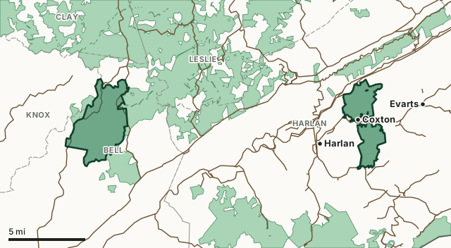
Asher Hunting Access AreaOther KDFWR public hunting areasNational forestLake or riverHighwayCounty line
| Size | 13,145 acres (KDFWR) |
|---|---|
| County | Bell County, Harlan County |
| KDFWR region | Southeast region |
| Deer zone of the county | Zone 4 |
| Deer telechecked, 2025-26 | 32 (25 antlered bucks, 7 does) |
| Elk | In the Elk Management Zone, hunting units 2 and 3 |
| Elevation | Minimum 1200 feet, maximum 3360 feet |
| Contact | (606)-654-2533 |
| Nearest towns | Coxton (next to it), Harlan (2 mi), Evarts (3 mi) and Loyall (3 mi) |
What are the 2026-27 hunting rules on Asher Hunting Access Area?
KDFWR lists these rules for the area. Where it says the area is open under statewide seasons, the county's zone rules apply.
Fall Hunting Season
- Open under statewide rules and regulations in effect for the county.
Exceptions
- Portions of the WMA are open during the quota elk hunts to persons who possess the appropriate elk hunting permit.
Source: KDFWR's page for Asher Hunting Access Area, read October 2026. Statewide seasons: 2026-27 Kentucky Hunting and Trapping Guide, page 10.
How many deer are taken on Asher Hunting Access Area?
Hunters telechecked 32 deer on Asher Hunting Access Area in the 2025-26 season: 25 antlered bucks, 0 button bucks and 7 does. Over the 10 seasons KDFWR reports, the area averaged 20 deer a season, from 8 in 2019-20 to 32 in 2025-26.
| Season | Deer telechecked | Antlered bucks | Does | Firearms | Archery | Crossbow | Muzzleloader |
|---|---|---|---|---|---|---|---|
| 2025-26 | 32 | 25 | 7 | 23 | 2 | 7 | 0 |
| 2024-25 | 23 | 18 | 5 | 21 | 1 | 0 | 1 |
| 2023-24 | 25 | 22 | 2 | 20 | 2 | 1 | 2 |
| 2022-23 | 30 | 24 | 6 | 23 | 3 | 3 | 1 |
| 2021-22 | 28 | 22 | 4 | 22 | 0 | 2 | 4 |
| 2020-21 | 16 | 13 | 3 | 9 | 2 | 2 | 3 |
| 2019-20 | 8 | 6 | 2 | 7 | 0 | 0 | 1 |
| 2018-19 | 25 | 22 | 3 | 19 | 1 | 0 | 5 |
| 2017-18 | 8 | 6 | 1 | 5 | 1 | 1 | 1 |
| 2016-17 | 9 | 8 | 1 | 6 | 0 | 1 | 2 |
Source: KDFWR Harvest Data (Telecheck), deer by public land. Antlered bucks are KDFWR's count of males with visible antlers; the rest of the males are button bucks.
Spring turkey telechecked on the area: 8 in 2025, 8 in 2024, 13 in 2023 and 4 in 2022 (KDFWR Harvest Data, spring season).
Elk telechecked on the area: 4 in 2025-26 (2 bulls, 2 cows), 5 in 2024-25 (3 bulls, 2 cows), 3 in 2023-24 (2 bulls, 1 cow), 5 in 2022-23 (4 bulls, 1 cow) and 3 in 2021-22 (3 bulls, 0 cows). See Kentucky elk hunting.
What kind of ground is Asher Hunting Access Area?
KDFWR describes the area's habitat as 88.02% forest, 11.93% open land and 0.02% open water. Elevation runs from 1200 feet to 3360 feet.
Which county is Asher Hunting Access Area in?
| County | Acres of the area in it | Deer zone | County deer, 2025-26 | Rank of 120 |
|---|---|---|---|---|
| Bell County | 8,194 | 4 | 661 | 89th |
| Harlan County | 4,947 | 4 | 509 | 104th |
Acres measured by FilledTag on KDFWR public hunting area boundaries and the U.S. Census Bureau 2024 county boundaries. County harvest: KDFWR Harvest Data (Telecheck), deer by county. Zones: KDFWR current deer zones.
How do you get to Asher Hunting Access Area?
To the Western Tract: From US 25E/HWY 66 in Pineville, travel 1.5 miles east on HWY 66, and turn right (east) onto HWY 221. Travel 9.2 miles and turn left (north) onto HWY 2011. Go 5.7 miles and turn left at the top of the hill. The western side of the area may also be reached from HWY 66, 13 miles northeast from Pineville. To the Eastern Tracts: Four miles east of Harlan on both sides of state road 38. The southern tract is also accessible off state road 2074. Area is open to hunting for statewide regulations and rules and regulations in effect for the county. Habitat consists primarily of reclaimed surface-mined and forested land. Foot travel only off of area mine roads or behind locked gates. Off-limit areas are indicated on the map. Owned by Asher Land and Mineral, LLLP. The western tract is located within Elk Hunting Unit 2. The eastern tracts are locations within Elk Hunting Unit 3.. Please refer to the elk portion of our website.
From KDFWR's page for the area.
Highways through the area: KY 66, KY 2011, KY 2074 and US 119. Nearest towns: Coxton (next to it), Harlan (2 miles), Evarts (3 miles), Loyall (3 miles) and Pineville (9 miles).
The closest other public hunting areas with a page here: Boone Forestlands WMA (next to it), Elk Forest WMA (next to it), Kentenia State Forest (next to it) and Daniel Boone National Forest (1.8 miles).
Questions hunters ask
When can you hunt Asher Hunting Access Area in 2026-27?
KDFWR's 2026-27 rules for Asher Hunting Access Area: Open under statewide rules and regulations in effect for the county.
How many deer were killed on Asher Hunting Access Area last season?
Hunters telechecked 32 deer on Asher Hunting Access Area in the 2025-26 season: 25 antlered bucks and 7 does. The most taken with firearms (23).
What county is Asher Hunting Access Area in?
Bell County (8,194 acres) and Harlan County (4,947 acres), measured on KDFWR's boundary.
What deer zone is Asher Hunting Access Area in?
Bell County is in Zone 4 and Harlan County is in Zone 4. Up to two deer, only one of which can be antlerless. Antlerless deer cannot be taken during the modern gun season, the early muzzleloader season or the first six days of the late muzzleloader season. Area rules can be stricter than the zone's, as listed above.
Are elk taken on Asher Hunting Access Area?
Yes. KDFWR's Telecheck reports show 4 elk in 2025-26, 5 elk in 2024-25 and 3 elk in 2023-24 on the area. Elk hunting is by quota permit; see Kentucky elk hunting.
Get a Kentucky hunt plan when they open
Hunt plans for Kentucky are coming. Join the list and you'll hear first. The first 50 hunters in each new state get their plan free.
Until then, the free FilledTag app for iPhone has a map that works in every state, Kentucky included.
Where these numbers come from
- Area rules, size, habitat, contact and directions: KDFWR, Asher Hunting Access Area.
- Deer, elk and turkey harvest on the area: KDFWR Harvest Data (Telecheck), deer by public land. County harvest: KDFWR Harvest Data (Telecheck), deer by county.
- Boundary: KDFWR public hunting area boundaries. Counties, highways and towns: U.S. Census Bureau 2024 county boundaries; U.S. Census Bureau TIGER/Line 2024 roads; U.S. Census Bureau 2024 Gazetteer. National forest and refuges: U.S. Forest Service national forest ownership; U.S. Fish and Wildlife Service refuge boundaries.
FilledTag is not part of Kentucky Fish and Wildlife. Numbers are copied from KDFWR or measured from public maps; nothing on this page is estimated by FilledTag.
Kentucky hunting All Kentucky WMAs Bell County deer harvest Harlan County deer harvest