Curtis Gates Lloyd WMA: deer harvest, 2026-27 rules and access
Curtis Gates Lloyd WMA is 1,105 acres of public hunting land in Grant County, in KDFWR's Bluegrass region. Hunters telechecked 26 deer on the area in the 2025-26 season, 9 antlered bucks among them. KDFWR's 2026-27 rule for the area: Open under statewide rules and regulations in effect for the county.
Data updated October 2026. Rules: KDFWR's page for the area. Harvest: KDFWR Telecheck reports, 2016-17 to 2025-26.
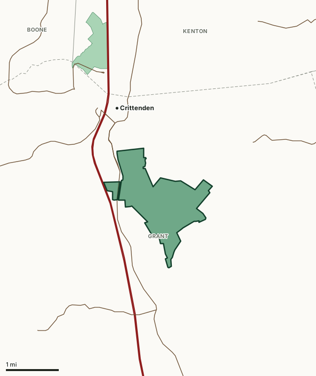
Curtis Gates Lloyd WMAOther KDFWR public hunting areasLake or riverHighwayCounty line
| Size | 1,105 acres (KDFWR) |
|---|---|
| County | Grant County |
| KDFWR region | Bluegrass region |
| Deer zone of the county | Zone 1 |
| Deer telechecked, 2025-26 | 26 (9 antlered bucks, 16 does) |
| Elevation | Minimum 720 feet, maximum 943 feet |
| Contact | (859) 428-2262 |
| Nearest towns | Crittenden (next to it), Dry Ridge (4 mi) and Walton (6 mi) |
What are the 2026-27 hunting rules on Curtis Gates Lloyd WMA?
KDFWR lists these rules for the area. Where it says the area is open under statewide seasons, the county's zone rules apply.
Fall Hunting Season
- Open under statewide rules and regulations in effect for the county.
Exceptions
- The huntable portion of Lloyd WMA will be closed to all access Nov. 14-21, except for hunters drawn for and participating in the deer quota hunt. The closure includes the tube range. Club ranges, the fishing pond and the hiking trail will remain open.
- Closed for the October deer muzzleloader season. Open for the December deer muzzleloader season.
- Closed to modern gun deer season.
- Rabbit and quail seasons are open Nov. 1-Dec. 31, except during deer quota hunts, and during the opening weekend of modern gun deer season.
- Unleashed dogs are prohibited from April 1 until the third Saturday in August, except during department-authorized field trials and the spring squirrel season.
- Shooting Range Information
- A person shall not target practice, sight in a firearm, or discharge a firearm in any area except the shooting range. Shooting multiple projectile shells is not permitted on Tube Ranges. Club Ranges are off-limits unless authorized by an approved event with a club range safety officer. A person shall not discharge a firearm within 100 yards of a residence or occupied building, whether or not the building is on the WMA.
Shooting Range Permit Required
- An annual or one-day shooting range permit is now required to use firearms and archery equipment on any department managed, leased or affiliated shooting range. The permit system will help the agency better gauge how many people use the ranges, promote safe practices, and support maintenance and improvements.
- The permit is free to annual hunting or fishing license holders, but you must obtain it through
- My Profile
Prohibited Activities
- Damage a tree or shrub (No installation of targets on trees or shrubs)
- Dump trash or litter (Clean up targets and spent shells)
- Deface or destroy a signs
- Pose a risk to persons or property (Shooters responsible for ensuring adequate backstop)
- Engage in an activity which could unreasonably interfere with other uses or users of the area
Source: KDFWR's page for Curtis Gates Lloyd WMA, read October 2026. Statewide seasons: 2026-27 Kentucky Hunting and Trapping Guide, page 10.
How many deer are taken on Curtis Gates Lloyd WMA?
Hunters telechecked 26 deer on Curtis Gates Lloyd WMA in the 2025-26 season: 9 antlered bucks, 1 button buck and 16 does. Over the 10 seasons KDFWR reports, the area averaged 20 deer a season, from 11 in 2024-25 to 30 in 2020-21.
| Season | Deer telechecked | Antlered bucks | Does | Firearms | Archery | Crossbow | Muzzleloader |
|---|---|---|---|---|---|---|---|
| 2025-26 | 26 | 9 | 16 | 0 | 13 | 6 | 7 |
| 2024-25 | 11 | 11 | 0 | 0 | 7 | 2 | 2 |
| 2023-24 | 12 | 5 | 5 | 2 | 7 | 1 | 2 |
| 2022-23 | 19 | 6 | 9 | 1 | 8 | 5 | 5 |
| 2021-22 | 15 | 7 | 7 | 0 | 9 | 2 | 4 |
| 2020-21 | 30 | 13 | 15 | 5 | 14 | 5 | 6 |
| 2019-20 | 16 | 7 | 9 | 0 | 14 | 2 | 0 |
| 2018-19 | 15 | 2 | 12 | 0 | 8 | 3 | 4 |
| 2017-18 | 26 | 4 | 20 | 0 | 21 | 1 | 4 |
| 2016-17 | 30 | 6 | 20 | 3 | 23 | 3 | 1 |
Source: KDFWR Harvest Data (Telecheck), deer by public land. Antlered bucks are KDFWR's count of males with visible antlers; the rest of the males are button bucks.
Spring turkey telechecked on the area: 2 in 2024, 4 in 2023, 1 in 2022 and 5 in 2021 (KDFWR Harvest Data, spring season).
What kind of ground is Curtis Gates Lloyd WMA?
KDFWR describes the area's habitat as 82.44% forest, 17.19% open land and 0.27% open water. Elevation runs from 720 feet to 943 feet.
Which county is Curtis Gates Lloyd WMA in?
| County | Acres of the area in it | Deer zone | County deer, 2025-26 | Rank of 120 |
|---|---|---|---|---|
| Grant County | 1,105 | 1 | 1,850 | 21st |
Acres measured by FilledTag on KDFWR public hunting area boundaries and the U.S. Census Bureau 2024 county boundaries. County harvest: KDFWR Harvest Data (Telecheck), deer by county. Zones: KDFWR current deer zones.
How do you get to Curtis Gates Lloyd WMA?
One-half mile southeast of Crittenden; from I-75 take Crittenden exit, follow US 25 south to left turn across railroad tracks to area. Level to rolling terrain with some steep hills, fields, woods. Nature trail through old hardwoods, one of state’s oldest forest stands. Public tube shooting range (for single projectile firearms only; no shotshells or pistols allowed) located off Wildlife Road: closed Monday, open Tuesday - Saturday 9:00 AM-sunset & Sundays noon-sunset. Trap, Skeet and Multi-Purpose Range are operated by local clubs and open to the public only during scheduled events for a nominal fee. Public Archery range open during daylight hours. Contact the WMA office or online calendar (see http://app.fw.ky.gov/Calendar/ and select Other ) for a current schedule, closures, events, and more info. Universal access to small fishing lake. Adm. Bldg. may be used by clubs. Please call only 8 a.m. to 4:30 p.m. Mon-Fri., Eastern. Fishing lakes, campgrounds nearby. Owned by Kentucky Department of Fish and Wildlife Resources.
From KDFWR's page for the area.
Highways within 5 miles: I-75, KY 491, US 25 and KY 14. Nearest towns: Crittenden (next to it), Dry Ridge (4 miles), Walton (6 miles) and Williamstown (7 miles).
The closest other public hunting areas with a page here: Mullins WMA (1.6 miles), Dr. Norman and Martha Adair WMA (11.3 miles), Decker WMA (17 miles) and Stephens Creek WMA (19.1 miles).
Questions hunters ask
When can you hunt Curtis Gates Lloyd WMA in 2026-27?
KDFWR's 2026-27 rules for Curtis Gates Lloyd WMA: Open under statewide rules and regulations in effect for the county.
How many deer were killed on Curtis Gates Lloyd WMA last season?
Hunters telechecked 26 deer on Curtis Gates Lloyd WMA in the 2025-26 season: 9 antlered bucks and 16 does. The most taken with archery (13).
What county is Curtis Gates Lloyd WMA in?
All of it is in Grant County, by KDFWR's boundary.
What deer zone is Curtis Gates Lloyd WMA in?
Grant County is in Zone 1. Unlimited number of antlerless deer using the statewide deer permit plus additional deer permits. Area rules can be stricter than the zone's, as listed above.
Get a Kentucky hunt plan when they open
Hunt plans for Kentucky are coming. Join the list and you'll hear first. The first 50 hunters in each new state get their plan free.
Until then, the free FilledTag app for iPhone has a map that works in every state, Kentucky included.
Where these numbers come from
- Area rules, size, habitat, contact and directions: KDFWR, Curtis Gates Lloyd WMA.
- Deer, elk and turkey harvest on the area: KDFWR Harvest Data (Telecheck), deer by public land. County harvest: KDFWR Harvest Data (Telecheck), deer by county.
- Boundary: KDFWR public hunting area boundaries. Counties, highways and towns: U.S. Census Bureau 2024 county boundaries; U.S. Census Bureau TIGER/Line 2024 roads; U.S. Census Bureau 2024 Gazetteer. National forest and refuges: U.S. Forest Service national forest ownership; U.S. Fish and Wildlife Service refuge boundaries.
FilledTag is not part of Kentucky Fish and Wildlife. Numbers are copied from KDFWR or measured from public maps; nothing on this page is estimated by FilledTag.
Kentucky hunting All Kentucky WMAs Grant County deer harvest