Carroll County, Maryland: deer harvest, public hunting areas and seasons
Hunters reported 5,270 deer in Carroll County in the 2025-26 season, 2,340 antlered and 2,930 antlerless, against 5,988 in 2024-25. Carroll County is in deer management Region B. 403 of the 2025-26 deer came off 10 public hunting areas DNR lists in the county. 1.6% of the county is public land.
Data updated October 2026. Harvest: Maryland DNR Annual Big Game Report 2025-2026. Seasons: Maryland DNR Hunting Seasons Calendar for 2026-2027. Land: DNR and PAD-US.
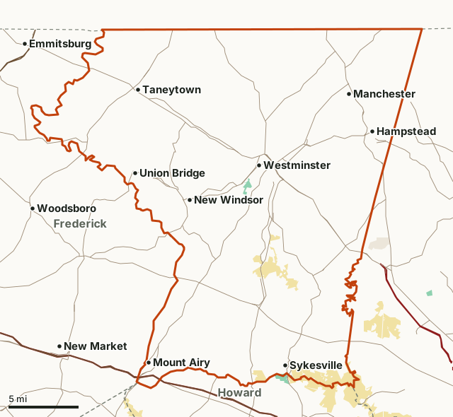
Wildlife management areaState parkMilitary (closed unless the base allows)Carroll CountyNeighboring countiesHighway
| Deer management region | Region B |
|---|---|
| Deer reported, 2025-26 | 5,270 (2,340 antlered, 2,930 antlerless) |
| Deer reported, 2024-25 | 5,988 |
| Public land | 1.6% (4,673 acres) |
| Deer taken on public areas, 2025-26 | 403 on 10 areas |
| Spring turkeys, 2026 | 130 |
| Firearm season, 2026 | November 28 to December 12 and January 8 to 10 |
How many deer are taken in Carroll County?
5,270 deer in 2025-26, down 12% from 5,988 in 2024-25. By weapon season:
| Season | Archery antlered | Archery antlerless | Firearm antlered | Firearm antlerless | Muzzleloader antlered | Muzzleloader antlerless | All deer |
|---|---|---|---|---|---|---|---|
| 2025-26 | 976 | 861 | 1,029 | 1,542 | 335 | 527 | 5,270 |
| 2024-25 | 989 | 1,069 | 1,100 | 2,035 | 279 | 516 | 5,988 |
Source: Maryland DNR Annual Big Game Report 2025-2026, Table 1; Maryland DNR Big Game Report 2024-2025, Table 1.
How has the antlerless harvest changed?
| Season | Antlerless deer |
|---|---|
| 2025-26 | 2,930 |
| 2024-25 | 3,620 |
| 2023-24 | 3,259 |
| 2022-23 | 3,434 |
| 2021-22 | 3,013 |
| 2020-21 | 4,006 |
| 2019-20 | 3,537 |
Sources: DNR's reports for each season (Maryland DNR deer and big game report archive); before 2024-25 from each report's button buck table, whose county rows add up to its statewide total.
Which public hunting areas in Carroll County give up the most deer?
| Public hunting area | Antlered, 2025-26 | Antlerless, 2025-26 | All deer, 2024-25 |
|---|---|---|---|
| Liberty Watershed | 70 | 88 | 194 |
| Morgan Run NEA | 21 | 45 | 61 |
| Patapsco Valley SP | 24 | 30 | 57 |
| Sawmill-Speigel CWMA | 15 | 32 | 44 |
| Hanover Watershed | 20 | 12 | 24 |
| Woodbrook CWMA | 9 | 12 | 31 |
| Avondale WMA | 5 | 7 | 17 |
| Maring CWMA | 5 | 4 | 10 |
| Farver CWMA | 2 | 0 | 2 |
| Hahn CWMA | 2 | 0 | 4 |
Source: Maryland DNR Annual Big Game Report 2025-2026, Appendix II; Maryland DNR Big Game Report 2024-2025. Linked areas have their own page.
When are the 2026-27 seasons in Carroll County?
| Season | Dates | Notes |
|---|---|---|
| Deer, archery | September 11 to October 21; October 25 to November 27; December 14 to 18; January 3 to 31, 2027 | Antlered deer statewide; antlerless 15 in Region B |
| Deer, early muzzleloader | October 22 to 24 | Antlered and antlerless |
| Deer, antlerless muzzleloader (Region B) | October 26 to 31 | Antlerless only |
| Deer, junior hunt | November 14 and 15 | Hunters 16 and younger, with an adult |
| Deer, firearm | November 28 to December 12; January 8 to 10, 2027 | Antlered; antlerless 10 in Region B |
| Deer, late muzzleloader | December 19 to January 2 | |
| Deer, primitive hunt days | February 1 to 3, 2027 | Longbow, recurve, flintlock or sidelock only |
| Turkey, winter | January 21 to 23, 2027 | |
| Turkey, spring | April 19 to May 24, 2027 (junior days April 17 to 18) |
Statewide, a hunter may take two antlered white-tailed deer a year, no more than one in a weapon season, plus one more with a Bonus Antlered Deer Stamp. Only one antlered deer a year may have fewer than three points on one antler; junior and apprentice hunters 16 and under are exempt.
Sources: Maryland DNR Hunting Seasons Calendar for 2026-2027; Maryland DNR: 2026-27 archery deer season opens September 11; Maryland DNR: early muzzleloader deer season opens October 22; Maryland DNR hunting regulation proposals for 2026-2027 and 2027-2028.
How many turkeys are taken in Carroll County?
| Spring season | 2026 | 2025 | 2024 | 2023 | 2022 | 2021 | 2020 |
|---|---|---|---|---|---|---|---|
| Turkeys | 130 | 118 | 125 | 132 | 94 | 104 | 93 |
Source: Maryland DNR Annual Big Game Report 2025-2026, wild turkey tables.
How much public land is in Carroll County?
1.6% of Carroll County is public land: 4,673 of its 290,151 acres. The largest share is state park, 4,473 acres.
| Manager | Acres | Share of Carroll County |
|---|---|---|
| State park | 4,473 | 1.5% |
| Wildlife management area | 200 | 0.1% |
Measured by FilledTag inside the county line from Maryland DNR owned lands (Maryland iMAP) for state land; USGS Protected Areas Database of the United States (PAD-US 4.1) for federal land. Not every acre of DNR land is open to hunting; DNR's page for each area has its rules.
Which counties border Carroll County?
| County | Region | Public land | Deer, 2025-26 | Antlered, 2025-26 | Spring turkeys, 2026 |
|---|---|---|---|---|---|
| Baltimore County | Region B | 5.5% | 4,779 | 2,008 | 85 |
| Frederick County | Region B | 5.2% | 6,342 | 2,900 | 294 |
| Howard County | Region B | 5.9% | 2,105 | 837 | 46 |
| Montgomery County | Region B | 5% | 3,069 | 1,229 | 137 |
Highways crossing Carroll County: MD 140 (34 miles), MD 97 (31 miles), MD 27 (28 miles), MD 32 (18 miles), MD 26 (14 miles) and MD 30 (13 miles). Towns inside: Westminster, Mount Airy, Taneytown and Hampstead.
Questions hunters ask
How many deer are taken in Carroll County, Maryland?
5,270 in 2025-26: 2,340 antlered and 2,930 antlerless (Maryland DNR Annual Big Game Report 2025-2026). In 2024-25 the county reported 5,988. By weapon, firearms took 2,571, archery 1,837 and muzzleloaders 862.
Where can you hunt deer on public land in Carroll County?
DNR's 2025-26 public land table lists 10 areas in the county. The most deer came off Liberty Watershed (158), Morgan Run NEA (66) and Patapsco Valley SP (54).
When is deer firearm season in Carroll County in 2026?
November 28 to December 12, and again January 8 to 10, 2027, in Region B (Maryland DNR Hunting Seasons Calendar for 2026-2027). Region B's firearm limit is 10 antlerless deer.
How many turkeys are taken in Carroll County?
130 in the 2026 spring season, against 118 in 2025 (Maryland DNR Annual Big Game Report 2025-2026). The 2027 spring season runs April 19 to May 24.
Get a Maryland hunt plan when they open
Hunt plans for Maryland are coming. Join the list and you'll hear first. The first 50 hunters in each new state get their plan free.
Until then, the free FilledTag app for iPhone has a map that works in every state, Maryland included.
Where these numbers come from
- Harvest: Maryland DNR Annual Big Game Report 2025-2026; Maryland DNR Big Game Report 2024-2025; earlier seasons from Maryland DNR deer and big game report archive.
- Seasons and limits: Maryland DNR Hunting Seasons Calendar for 2026-2027; Maryland DNR: 2026-27 archery deer season opens September 11; Maryland DNR: early muzzleloader deer season opens October 22.
- County boundary: Maryland county boundaries (Maryland iMAP). Public land: Maryland DNR owned lands (Maryland iMAP) for state land; USGS Protected Areas Database of the United States (PAD-US 4.1) for federal land.
- Highways and towns: U.S. Census Bureau TIGER/Line 2024 primary and secondary roads; U.S. Census Bureau 2024 Gazetteer, places.
FilledTag is not part of the Maryland Department of Natural Resources. Numbers are copied from DNR and federal sources or measured from their maps; nothing on this page is estimated by FilledTag.
Maryland hunting Baltimore County Frederick County Howard County Montgomery County