George L. Darey Housatonic Valley Wildlife Management Area: hunting, access and parking in Zone 2
George L. Darey Housatonic Valley Wildlife Management Area is 874 acres of MassWildlife land in Lee, Lenox and Pittsfield (Berkshire County), in Wildlife Management Zone 2 and 3. MassWildlife says all of its WMAs are open to hunting, fishing and trapping. Hunters took 617 deer in Zone 2 in 2025, and MassWildlife maps 4 parking areas for the property with room for about 22 vehicles.
Data updated October 2026. Area facts: MassWildlife's George L. Darey Housatonic Valley WMA fact sheet. Harvest: MassWildlife 2025 Deer Harvest Summary. Seasons: MassWildlife deer hunting regulations (2026 dates).
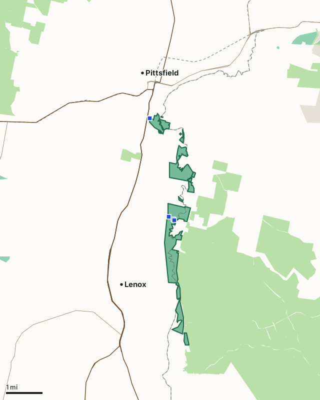
MassWildlife (Fish and Game) landState forest and park land (DCR)National Park ServiceGeorge L. Darey Housatonic Valley WMAZone lineParkingHighway
| Size | 874 acres (MassWildlife), in 13 pieces |
|---|---|
| Town | Lee, Lenox and Pittsfield |
| County | Berkshire |
| Wildlife Management Zone | Zone 2, Zone 3 |
| MassWildlife district | Western District |
| Parking (MassWildlife) | 4 lots, about 22 spaces |
| Pheasant | Stocked; blaze orange hat required in pheasant season |
| Deer taken in Zone 2, 2025 | 617 (492 adult males) |
| Nearest town centers | Pittsfield (under a mile), Lenox (under a mile) and Lee (3 mi) |
What is George L. Darey Housatonic Valley WMA like?
MassWildlife describes it: "The acquisition of this property in the 1960s resulted from cooperation among local conservationists, including George Darey, for whom the WMA is named. The property is comprised of several parcels along the Housatonic floodplain. River oxbows and backwaters are interspersed with seasonally flooded forests, shrub swamps, and open-water marshes. Abandoned agricultural fields and blueberry bushes line the river in many places. The slow-moving current, abundant wildlife, and wide riverbends make this WMA one of the most beautiful paddling locations in the region. Kayaks and canoes can be launched at the Decker Access on the south side of New Lenox Road, as well as several locations along Woodland Road in Lee. The WMA abuts large tracts of other conserved land, including October Mountain State Forest to the east. This biologically rich area has a history that includes severe PCB contamination and has long been a focus of advocates throughout the environmental community."
On wildlife: "More than 200 species of birds have been observed in this section of the river valley. Wetland-dependent birds like American bitterns, soras, Virginia rails, and common moorhens have been spotted. Several species of swallows can be seen along the river. Semi-aquatic mammals like beavers and muskrats are common and numerous other bird and mammal species take advantage of the wide floodplain. The many oxbows and mineral-rich seeps support an impressive array of specialized and unusual plants and invertebrates. A paddle at dawn or dusk through this WMA provides a quintessential Berkshire experience."
Quoted from MassWildlife's George L. Darey Housatonic Valley WMA fact sheet.
What does MassWildlife say about hunting George L. Darey Housatonic Valley WMA?
"White-tailed deer, bears, and wild turkeys are present in the swamps and woodlands along the river. Waterfowl* are common throughout. American woodcock and ruffed grouse can be found in the shrublands along the floodplain. MassWildlife maintains open field habitats in areas north and south of New Lenox Road that attract deer and turkeys and provide cover for ring-necked pheasants, which are stocked there each fall. The Housatonic River and Woods Pond offer excellent warmwater fishing for black crappie, sunfish, pickerel, smallmouth bass, and largemouth bass. This is a premier location for northern pike fishing in open water and through the ice. Large carp frequent the shallow backwaters in the spring. Brown trout and rainbow trout can be found in the northern part of the WMA. The best way to fish the area is by kayak or canoe, which can be launched from a number of locations along the river. (See consumption advisory.)"
Its rules for the area: "A “hunter orange” hat is required wear for hunters during the pheasant season."
How do you get into George L. Darey Housatonic Valley WMA?
"Dirt parking lots can be found on both sides New Lenox Road in Lenox. Parking can also be found at the end of Underhill Place in Pittsfield and on the side of Roaring Brook/Woodland Road in Lenox and Lee."
| Parking | Spaces | Surface | Condition | Latitude | Longitude |
|---|---|---|---|---|---|
| Parking | 10 | Dirt | Fair | 42.39502 | -73.24521 |
| Parking | 6 | Dirt/Grass | Fair | 42.39418 | -73.24300 |
| Boat launch | 5 | Gravel | Good | 42.39373 | -73.24235 |
| Parking | 1 | Dirt | Fair | 42.43397 | -73.25639 |
From MassWildlife parking for recreation.
Highways within five miles: US 20, US 7, I-90, MA 9, MA 8 and MA 183. Distances to the nearest town centers: Pittsfield under a mile, Lenox under a mile, Lee 3 miles and Washington 4 miles. Other WMAs nearby: Fairfield Brook (5 miles), Day Mountain (6 miles), Hinsdale Flats (7 miles).
When can you hunt deer on George L. Darey Housatonic Valley WMA in 2026?
Deer seasons follow Zone 2: archery October 5 to November 28, shotgun November 30 to December 12, primitive firearms December 14 to 31. In 2025 the zone gave 244 deer to archers and 281 in shotgun season.
Seasons: MassWildlife deer hunting regulations (2026 dates). Harvest: MassWildlife 2025 Deer Harvest Summary; MassWildlife 2024 Deer Harvest Summary.
What rules apply on George L. Darey Housatonic Valley WMA?
It is stocked with pheasant, so every hunter must wear a blaze orange hat during pheasant season, except raccoon and opossum hunters at night and waterfowl hunters in a blind or boat. Under 321 CMR 3.01, camping, fires and target practice need the Director's written permission, vehicles stay on roads open to traffic, and dogs must be leashed unless hunting or training with a licensed hunter.
Source: MassWildlife WMA regulations.
Questions hunters ask
Can you hunt on George L. Darey Housatonic Valley WMA?
Yes. MassWildlife says all WMAs are open to hunting, fishing and trapping; deer seasons follow Zone 2, where the 2026 shotgun season runs November 30 to December 12 (MassWildlife WMA regulations).
What zone is George L. Darey Housatonic Valley WMA in?
Zone 2 (327 acres) and Zone 3 (547 acres), as MassWildlife's fact sheet gives it. Hunters took 617 deer in Zone 2 in 2025, 492 of them adult males, after 546 in 2024 (MassWildlife 2025 Deer Harvest Summary).
Where do you park for George L. Darey Housatonic Valley WMA?
MassWildlife maps 4 parking areas: a lot (about 10 cars, dirt); a lot (about 6 cars, dirt/grass); Boat launch (about 5 cars, gravel); a lot (one car, dirt). Its fact sheet adds: "Dirt parking lots can be found on both sides New Lenox Road in Lenox. Parking can also be found at the end of Underhill Place in Pittsfield and on the side of Roaring Brook/Woodland Road in Lenox and Lee."
What can you hunt on George L. Darey Housatonic Valley WMA?
MassWildlife's fact sheet: "White-tailed deer, bears, and wild turkeys are present in the swamps and woodlands along the river. Waterfowl* are common throughout. American woodcock and ruffed grouse can be found in the shrublands along the floodplain. MassWildlife maintains open field habitats in areas north and south of New Lenox Road that attract deer and turkeys and provide cover for ring-necked pheasants, which are stocked there each fall."
Get a Massachusetts hunt plan when they open
Hunt plans for Massachusetts are coming. Join the list and you'll hear first. The first 50 hunters in each new state get their plan free.
Until then, the free FilledTag app for iPhone has a map that works in every state, Massachusetts included.
Sources: MassWildlife fact sheet; MassWildlife Lands (MassGIS); MassWildlife parking for recreation; MassWildlife 2025 Deer Harvest Summary; MassWildlife deer hunting regulations (2026 dates); MassWildlife WMA regulations; public land MassGIS Protected and Recreational OpenSpace for state and Army Corps land; USGS Protected Areas Database of the United States (PAD-US 4.1) for federal land; towns U.S. Census Bureau TIGER/Line 2024 primary and secondary roads; U.S. Census Bureau 2024 Gazetteer, towns (county subdivisions). FilledTag is not part of Massachusetts Division of Fisheries and Wildlife (MassWildlife).