Massachusetts deer hunting: zones, harvest and 2026 seasons
Massachusetts hunters took 16,681 deer in the 2025 seasons, a state record, 8,950 of them adult males. Zones 10 and 11, the eastern and southeastern mainland, gave 40% of the harvest. The 2026 shotgun season runs November 30 to December 12.
Data updated October 2026. Harvest: MassWildlife 2025 Deer Harvest Summary. Seasons: MassWildlife deer hunting regulations (2026 dates).
Massachusetts hunt plans are coming
Hunt plans for Massachusetts are coming. Join the list and you'll hear first. Join the Massachusetts list.
When are Massachusetts's 2026 deer seasons?
| Season | Dates | Notes |
|---|---|---|
| Early deer season | September 21 to October 1 | Zones 13 and 14 only |
| Youth deer hunt | October 2 and 3 | Youth deer hunt permit, ages 12 to 17 |
| Archery | October 5 to November 28 | Archery stamp |
| Paraplegic hunt | October 29 to 31 | By permit |
| Shotgun | November 30 to December 12 | No stamp needed |
| Primitive firearms | December 14 to 31 | Primitive firearms stamp |
| Winter deer season | January 1 to 30, 2027 | Zones 9, 10 and 11 |
| Winter deer season | January 1 to February 13, 2027 | Zones 13 and 14 |
Source: MassWildlife deer hunting regulations (2026 dates).
How many deer are taken in Massachusetts each year?
| Year | Adult males | Females | Male fawns | All deer |
|---|---|---|---|---|
| 2025 | 8,950 | 6,570 | 1,161 | 16,681 |
| 2024 | 8,091 | 5,903 | 1,070 | 15,064 |
| 2023 | 8,858 | 5,612 | 1,052 | 15,522 |
| 2022 | 9,076 | 5,516 | 1,261 | 15,853 |
| 2021 | 8,042 | 4,361 | 963 | 13,366 |
| 2020 | 8,506 | 5,116 | 1,144 | 14,766 |
| 2019 | 7,752 | 5,156 | 983 | 13,891 |
| 2018 | 8,179 | 5,237 | 1,100 | 14,516 |
| 2017 | 7,918 | 4,348 | 989 | 13,255 |
| 2016 | 7,006 | 4,181 | 1,009 | 12,196 |
Summed from the zone rows of MassWildlife deer harvest data's yearly summaries, 2016 to 2025.
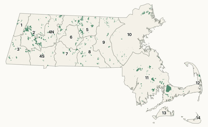
Massachusetts's Wildlife Management Zones
The most deer in 2025 came from Zone 11 (4,153), Zone 10 (2,515) and Zone 9 (1,534).
| Zone | Square miles | Deer, 2025 | Deer, 2024 | Adult males, 2025 | Public land |
|---|---|---|---|---|---|
| Zone 1 | 187 | 414 | 347 | 269 | 28.2% |
| Zone 2 | 582 | 617 | 546 | 492 | 25.6% |
| Zone 3 | 422 | 706 | 650 | 419 | 17.6% |
| Zone 4N | 435 | 727 | 612 | 472 | 11.1% |
| Zone 4S | 409 | 479 | 360 | 361 | 9.3% |
| Zone 5 | 589 | 917 | 798 | 541 | 22.9% |
| Zone 6 | 312 | 351 | 384 | 194 | 33.8% |
| Zone 7 | 398 | 945 | 824 | 497 | 7% |
| Zone 8 | 576 | 1,004 | 865 | 625 | 12.7% |
| Zone 9 | 743 | 1,534 | 1,374 | 742 | 10.2% |
| Zone 10 | 1,448 | 2,515 | 2,423 | 1,320 | 6.5% |
| Zone 11 | 1,430 | 4,153 | 3,830 | 2,120 | 7% |
| Zone 12 | 403 | 381 | 382 | 193 | 18.2% |
| Zone 13 | 109 | 935 | 798 | 346 | 8.9% |
| Zone 14 | 49 | 1,003 | 871 | 359 | 0.4% |
Harvest: MassWildlife 2025 Deer Harvest Summary; MassWildlife 2024 Deer Harvest Summary. Public land measured by FilledTag from MassGIS Protected and Recreational OpenSpace for state and Army Corps land; USGS Protected Areas Database of the United States (PAD-US 4.1) for federal land.
How much of Massachusetts is public hunting ground?
13.1% of Massachusetts is state or federal land: state forest and park land (DCR) 321,929 acres, MassWildlife (Fish and Game) land 184,663 acres, DCR watershed land (Quabbin, Wachusett, Ware River) 105,576 acres, National Park Service 28,713 acres, Army Corps of Engineers 18,158 acres and national wildlife refuge 17,057 acres. MassWildlife says it owns and manages over 220,000 acres, all open to hunting, fishing and trapping.
Wildlife Management Areas with their own page
- Abbott Brook, 18 acres
- Agawam Lake, 785.75 acres
- Ashby, 1,190.76 acres
- Ashfield Hawley, 284 acres
- Atwood Reservoir, 513 acres
- Bachelor Brook, 93.7 acres
- Barton's Ledge, 146.6 acres
- Bearse Pond, 5.8 acres
- Bennett Meadows, 201 acres
- Bennett, 281.2 acres
- Birch Hill, 4,560.55 acres
- Black Brook, 411.32 acres
- Bolton Flats, 1,353.98 acres
- Boxborough Station, 124.1 acres
- Breakneck Brook, 787 acres
- Burrage Pond, 1,886.34 acres
- Camp Cachalot, 789 acres
- Camp Edwards, 15,013.16 acres
- Canoe River, 116.6 acres
- Catamount, 413 acres
- Chalet, 7,804.33 acres
- Charles River, 3,017.96 acres
- Chase Garden Creek, 56.4 acres
- Chockalog Swamp, 52.5 acres
- Clapps Pond, 68.35 acres
- Clinton Bluff, 42 acres
- Cooks Pond, 69.18 acres
- Copicut, 4,017.56 acres
- Coy Hill, 1,224.25 acres
- Crane Pond, 2,679.64 acres
- Cummington, 424 acres
- Dartmoor Farm, 473 acres
- Darwin Scott, 27.3 acres
- Day Mountain, 387.54 acres
- Delaney, 658 acres
- Dennis Grassy Pond, 7.24 acres
- Dolomite Ledges, 389.87 acres
- Dunstable Brook, 207.35 acres
- E. Kent Swift, 234 acres
- East Mountain, 612.85 acres
- Eastham Salt Marsh, 7.44 acres
- Elbow Meadow, 210.33 acres
- English Salt Marsh, 289 acres
- Erwin S. Wilder, 651 acres
- Eugene D. Moran, 1,870.43 acres
- Facing Rock, 1,388.89 acres
- Fairfield Brook, 165 acres
- Farmington River, 1,926 acres
- Fish Brook, 143 acres
- Fisk Forestdale, 93 acres
- Fisk Meadows, 622 acres
- Flagg Mountain, 160 acres
- Flagg Swamp, 54 acres
- Flat Brook, 273 acres
- Four Chimneys, 18 acres
- Fox Den, 5,910 acres
- Fox Island, 71 acres
- Frances A. Crane, 2,466 acres
- George L. Darey Housatonic Valley, 874 acres
- Gosnold, 7 acres
- Great Swamp, 706 acres
- Green River, 382 acres
- Green River WMA - Williamstown, 597 acres
- Halfway Pond, 123 acres
- Hartley Reservoir, 70 acres
- Haskell Swamp, 3,104 acres
- Hauk Swamp, 61 acres
- Head of the Plains, 2 acres
- Herman Covey, 1,505 acres
- High Ridge, 1,040 acres
- Hinsdale Flats, 1,941 acres
- Hiram H. Fox, 3,781 acres
- Hitchcock Mountain, 268 acres
- Hockomock Swamp, 6,157 acres
- Hog Mountain, 249 acres
- Hog Ponds, 25 acres
- Honey Pot, 178 acres
- Hop Brook, 527 acres
- Housatonic River East Branch, 28 acres
- Hubbardston, 361 acres
- Hunting Hills, 430 acres
- Hyannis Ponds, 365 acres
- John J. Kelly, 342 acres
- Jug End State Reservation and WMA, 1,190 acres
- Kampoosa Fen, 72 acres
- Karner Brook, 54 acres
- Katama Plains, 19 acres
- Knightville Dam, 378 acres
- Lackey Pond, 175 acres
- Lake Warner, 98 acres
- Lawrence Brook, 406 acres
- Leadmine, 826 acres
- Leyden, 759 acres
- Lilly Pond, 383 acres
- Long Mountain, 1,014 acres
- Maple Hill, 728 acres
- Maple Springs, 576 acres
- Martha Deering, 181 acres
- Martin H. Burns, 2,135 acres
- Mashpee Pine Barrens, 203 acres
- Mashpee River, 42 acres
- Mattapoisett River, 163 acres
- McKinstry Brook, 291 acres
- Meadow Brook, 71 acres
- Meetinghouse Swamp, 123 acres
- Merrill Pond, 984 acres
- Miacomet Heath, 3.8 acres
- Mill Brook Bogs, 571 acres
- Millers River, 2,288 acres
- Mine Brook, 1,062 acres
- Misery Mountain, 649 acres
- Montague Plains, 1,575 acres
- Montague, 1,805 acres
- Moose Brook, 453 acres
- Moose Hill, 594 acres
- Mt. Esther, 329 acres
- Mt. Pisgah, 89 acres
- Mt. Toby, 682 acres
- Mt. Tom, 80 acres
- Muddy Brook, 1,937 acres
- Muddy Pond, 3 acres
- Mulpus Brook, 472 acres
- Nissitissit River, 627 acres
- Noquochoke, 205 acres
- North Attleborough, 36 acres
- North Egremont, 26 acres
- Oak Hill, 673 acres
- Oakham, 742 acres
- Old Sandwich Game Farm, 93 acres
- Olivers Pond, 12 acres
- Orange, 559 acres
- Palmer, 1,260 acres
- Pantry Brook, 148 acres
- Pauchaug Brook, 250 acres
- Peru, 5,143 acres
- Peterson Swamp, 70 acres
- Phillipston, 3,388 acres
- Pickerel Cove, 16 acres
- Plymouth Grassy Pond, 26 acres
- Poland Brook, 392 acres
- Poor Meadow Brook, 117 acres
- Popple Camp, 1,052 acres
- Poutwater Pond, 392 acres
- Powell Brook, 405 acres
- Prince River, 787 acres
- Provincetown Corridor, 112 acres
- Puddingstone, 208 acres
- Purchade Brook, 106 acres
- Quaboag, 1,822 acres
- Quacumquasit, 180 acres
- Quashnet River, 468 acres
- Quisset, 425 acres
- Raccoon Hill, 646 acres
- Red Brook, 683 acres
- Richardson, 467 acres
- Rockdale Highlands, 507 acres
- Rocky Gutter, 3,178 acres
- SE Pine Barrens, 185 acres
- Salisbury Salt Marsh, 825 acres
- Sandwich Hollows, 224 acres
- Satan's Kingdom, 1,789 acres
- Savage Hill, 1,066 acres
- Savoy, 1,985 acres
- Scripture Hill, 121 acres
- Shaker Mill Brook, 26.4 acres
- Shales Brook, 308 acres
- Shattuck Brook, 179 acres
- Shaw Brook, 153 acres
- Sippican Headwaters, 336 acres
- Sly Pond, 192 acres
- South Shore Marshes, 22 acres
- South Triangle Pond, 10 acres
- Southampton, 171 acres
- Southwick, 265 acres
- Squannacook River, 1,306 acres
- Stafford Hill, 860 acres
- Stone Bridge, 201 acres
- Sucker Brook, 103 acres
- Sunderland Islands, 15 acres
- Swift River, 757 acres
- Taunton River, 349 acres
- Tekoa Mountain, 1,383 acres
- Thayer Pond, 131 acres
- Three Mile Pond, 1,142 acres
- Townsend Hill, 521 acres
- Tracy Pond, 323 acres
- Trapfall Brook, 45 acres
- Triangle Pond, 16 acres
- Tully Mountain, 645 acres
- Unkety Brook, 430 acres
- Upper Parker River, 171 acres
- Upper Westfield River, 329 acres
- Wales, 207 acres
- Walnut Hill, 989 acres
- Ware River, 185 acres
- Warwick, 379 acres
- Wasque Point, 100 acres
- Wayne F. MacCallum, 906 acres
- Wendell, 601 acres
- West Meadows, 424 acres
- Westfield, 233 acres
- Whately, 341 acres
- Whittier, 42 acres
- Whortleberry Hill, 324 acres
- William Forward, 2,083 acres
- Williamsburg, 88 acres
- Winchendon Springs, 675 acres
- Winimusset, 2,129 acres
- Winnetuxet River, 44 acres
- Wolf Swamp, 1,358 acres
Questions hunters ask
When is deer season in Massachusetts in 2026?
Archery October 5 to November 28, shotgun November 30 to December 12 and primitive firearms December 14 to 31. The youth hunt is October 2 and 3; zones 13 and 14 open early, September 21 to October 1, and zones 9, 10, 11, 13 and 14 have a winter season in January 2027 (MassWildlife deer hunting regulations (2026 dates)).
How many deer were taken in Massachusetts in 2025?
16,681, a state record: 8,950 adult males, 6,570 females and 1,161 male fawns, up from 15,064 in 2024 (MassWildlife 2025 Deer Harvest Summary). The most came from Zone 11 (4,153), Zone 10 (2,515) and Zone 9 (1,534).
How many antlered deer can you take in Massachusetts?
Two a year, in any zone, on the tags that come with a hunting, sporting or nonresident big game license. Antlerless deer need an antlerless deer permit for a named zone; hunters apply by July 16 (MassWildlife deer hunting regulations (2026 dates)).
Can you use a rifle for deer in Massachusetts?
No. Shotguns no larger than 10 gauge are allowed in shotgun season, muzzleloaders of .44 to .775 caliber in primitive season, and archery in every deer season; rifles and handguns may not be used while deer may be hunted with a shotgun (MassWildlife deer hunting regulations (2026 dates)).
Get a Massachusetts hunt plan when they open
Hunt plans for Massachusetts are coming. Join the list and you'll hear first. The first 50 hunters in each new state get their plan free.
Until then, the free FilledTag app for iPhone has a map that works in every state, Massachusetts included.
Where these numbers come from
- Seasons: MassWildlife deer hunting regulations (2026 dates). WMA rules: MassWildlife WMA regulations.
- Harvest: MassWildlife deer harvest data; MassWildlife Deer Harvest Summaries, 2016 to 2025.
- Zones: MassWildlife Wildlife Management Zones (MassGIS). WMAs: MassWildlife Lands (MassGIS). Public land: MassGIS Protected and Recreational OpenSpace for state and Army Corps land; USGS Protected Areas Database of the United States (PAD-US 4.1) for federal land.
FilledTag is not part of Massachusetts Division of Fisheries and Wildlife (MassWildlife). MassWildlife's hunting pages are the final word on every rule.