Montague Plains Wildlife Management Area: hunting, access and parking in Zone 5
Montague Plains Wildlife Management Area is 1,575 acres of MassWildlife land in Montague (Franklin County), in Wildlife Management Zone 5. MassWildlife says all of its WMAs are open to hunting, fishing and trapping. Hunters took 917 deer in Zone 5 in 2025.
Data updated October 2026. Area facts: MassWildlife's Montague Plains WMA fact sheet. Harvest: MassWildlife 2025 Deer Harvest Summary. Seasons: MassWildlife deer hunting regulations (2026 dates).
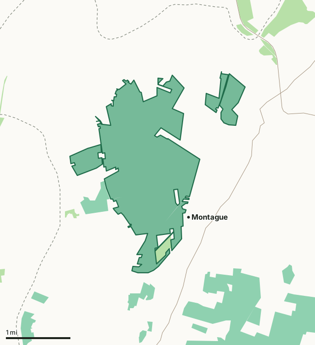
MassWildlife (Fish and Game) landState forest and park land (DCR)Montague Plains WMAZone lineHighway
| Size | 1,575 acres (MassWildlife), in 4 pieces |
|---|---|
| Town | Montague |
| County | Franklin |
| Wildlife Management Zone | Zone 5 |
| MassWildlife district | Connecticut Valley District |
| Parking (MassWildlife) | None mapped |
| Pheasant | Stocked; blaze orange hat required in pheasant season |
| Deer taken in Zone 5, 2025 | 917 (541 adult males) |
| Nearest town centers | Montague (under a mile), Gill (2 mi) and Greenfield (4 mi) |
What is Montague Plains WMA like?
MassWildlife describes it: "This property contains the state’s largest inland occurrence of a pitch pine - scrub oak natural community, a fire-adapted community which supports a diversity of rare plants and wildlife and other species of conservation concern. This habitat type occurs on large glacial outwash sandplains of dry, poor soils."
On its habitat work: "Montague Plains Wildlife Management Area contains the largest inland fire-influenced pine barrens habitat in Massachusetts. The deep coarse glacial sands that underlay the area gives rise to its unique features. Barrens are home to a collection of specialized plants and animals and are characterized by an open tree canopy and lots of shrubby undergrowth. This kind of habitat is both regionally and globally imperiled. Over the past two decades, several phases of tree cutting, shrub mowing, invasive plant control, and grassland planting have been completed. The open canopy and dense understory you see today is maintained by a combination of mowing and prescribed burning."
On wildlife: "Due to the extensive pitch pine-scrub oak restoration efforts, this WMA provides great opportunities for wildlife watching. Birders may observe species including prairie warbler, eastern whip-poor-will, and brown thrasher. The WMA also supports a wide variety of lepidoptera (butterflies & moths)."
Quoted from MassWildlife's Montague Plains WMA fact sheet.
What does MassWildlife say about hunting Montague Plains WMA?
"This is a pheasant stocked area. Other opportunities exist to hunt for white-tailed deer, wild turkey, ruffed grouse, cottontail rabbit, raccoon, fox, and eastern coyote."
Its rules for the area: "During pheasant season, a blaze orange hat must be worn by all hunters except while night-hunting raccoons or opossums or while hunting waterfowl from within a blind or boat."
How do you get into Montague Plains WMA?
"The property can be accessed from Hillside Road, Turnpike Road, Turners Falls Road, Plains Road, Lake Pleasant Road, and Old Northfield Road. Multiple pull-offs exist off of Old Northfield Road and Plains Road."
MassWildlife's parking layer shows no lot for Montague Plains WMA.
Highways within five miles: I-91, MA 2, MA 63, MA 10, US 5 and MA 47. Distances to the nearest town centers: Montague under a mile, Gill 2 miles, Greenfield 4 miles and Erving 4 miles. Other WMAs nearby: Montague (4 miles), Sunderland Islands (6 miles), Mt. Toby (6 miles).
When can you hunt deer on Montague Plains WMA in 2026?
Deer seasons follow Zone 5: archery October 5 to November 28, shotgun November 30 to December 12, primitive firearms December 14 to 31. In 2025 the zone gave 337 deer to archers and 411 in shotgun season.
| Zone | WMA acres in it | Deer, 2025 | Adult males, 2025 | Deer, 2024 |
|---|---|---|---|---|
| Zone 5 | 2,021 | 917 | 541 | 798 |
Seasons: MassWildlife deer hunting regulations (2026 dates). Harvest: MassWildlife 2025 Deer Harvest Summary; MassWildlife 2024 Deer Harvest Summary.
What rules apply on Montague Plains WMA?
It is stocked with pheasant, so every hunter must wear a blaze orange hat during pheasant season, except raccoon and opossum hunters at night and waterfowl hunters in a blind or boat. Under 321 CMR 3.01, camping, fires and target practice need the Director's written permission, vehicles stay on roads open to traffic, and dogs must be leashed unless hunting or training with a licensed hunter.
Source: MassWildlife WMA regulations.
Questions hunters ask
Can you hunt on Montague Plains WMA?
Yes. MassWildlife says all WMAs are open to hunting, fishing and trapping; deer seasons follow Zone 5, where the 2026 shotgun season runs November 30 to December 12 (MassWildlife WMA regulations).
What zone is Montague Plains WMA in?
Zone 5, as MassWildlife's fact sheet gives it. Hunters took 917 deer in Zone 5 in 2025, 541 of them adult males, after 798 in 2024 (MassWildlife 2025 Deer Harvest Summary).
How do you get into Montague Plains WMA?
MassWildlife's fact sheet: "The property can be accessed from Hillside Road, Turnpike Road, Turners Falls Road, Plains Road, Lake Pleasant Road, and Old Northfield Road. Multiple pull-offs exist off of Old Northfield Road and Plains Road."
What can you hunt on Montague Plains WMA?
MassWildlife's fact sheet: "This is a pheasant stocked area. Other opportunities exist to hunt for white-tailed deer, wild turkey, ruffed grouse, cottontail rabbit, raccoon, fox, and eastern coyote."
Get a Massachusetts hunt plan when they open
Hunt plans for Massachusetts are coming. Join the list and you'll hear first. The first 50 hunters in each new state get their plan free.
Until then, the free FilledTag app for iPhone has a map that works in every state, Massachusetts included.
Sources: MassWildlife fact sheet; MassWildlife Lands (MassGIS); MassWildlife parking for recreation; MassWildlife 2025 Deer Harvest Summary; MassWildlife deer hunting regulations (2026 dates); MassWildlife WMA regulations; public land MassGIS Protected and Recreational OpenSpace for state and Army Corps land; USGS Protected Areas Database of the United States (PAD-US 4.1) for federal land; towns U.S. Census Bureau TIGER/Line 2024 primary and secondary roads; U.S. Census Bureau 2024 Gazetteer, towns (county subdivisions). FilledTag is not part of Massachusetts Division of Fisheries and Wildlife (MassWildlife).