Misery Mountain Wildlife Management Area: hunting, access and parking in Zone 1
Misery Mountain Wildlife Management Area is 649 acres of MassWildlife land in Hancock and Williamstown (Berkshire County), in Wildlife Management Zone 1. MassWildlife says all of its WMAs are open to hunting, fishing and trapping. Hunters took 414 deer in Zone 1 in 2025, and MassWildlife maps 2 parking areas for the property with room for about 6 vehicles.
Data updated October 2026. Area facts: MassWildlife's Misery Mountain WMA fact sheet. Harvest: MassWildlife 2025 Deer Harvest Summary. Seasons: MassWildlife deer hunting regulations (2026 dates).
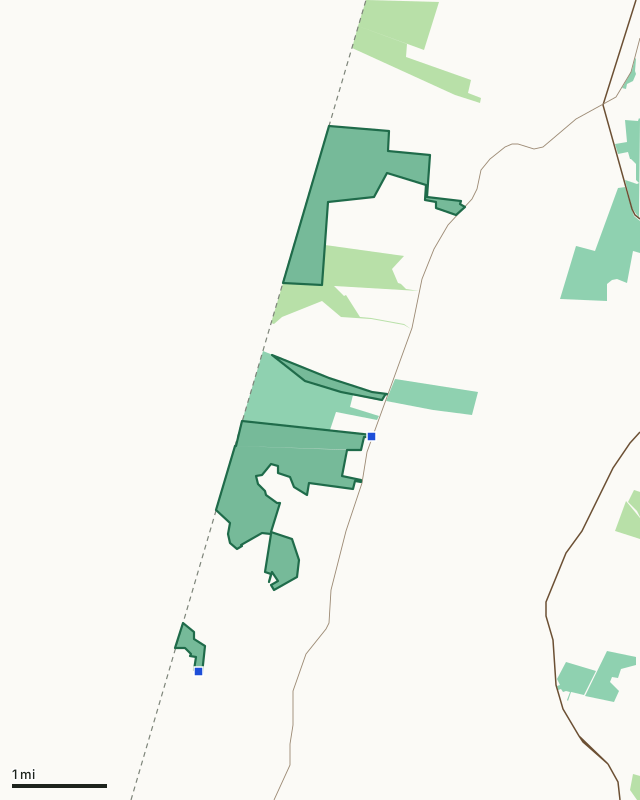
MassWildlife (Fish and Game) landState forest and park land (DCR)Misery Mountain WMAZone lineParkingHighway
| Size | 649 acres (MassWildlife), in 4 pieces |
|---|---|
| Town | Hancock and Williamstown |
| County | Berkshire |
| Wildlife Management Zone | Zone 1 |
| MassWildlife district | Western District |
| Parking (MassWildlife) | 2 lots, about 6 spaces |
| Deer taken in Zone 1, 2025 | 414 (269 adult males) |
| Nearest town centers | Hancock (3 mi), New Ashford (3 mi) and Williamstown (4 mi) |
What is Misery Mountain WMA like?
MassWildlife describes it: "Misery Mountain WMA consists of 2 parcels along the steep sloped terrain of the Taconic Mountain Range. Sections of this range rise above 2,000 feet and offer views of the Hudson River Valley to the west. This property consists mostly of northern hardwoods with some spruce and fir tree species. The western border of the property is also the border with New York."
On wildlife: "The Taconic Trail runs through portions of Misery Mountain and provides views of the Berkshire and Taconic mountains."
Quoted from MassWildlife's Misery Mountain WMA fact sheet.
What does MassWildlife say about hunting Misery Mountain WMA?
"This property features steep inclines but contains excellent habitat and food sources for black bear and white-tailed deer. The nearby E. Howe Forbush Sanctuary and Taconic Trail State Forest provide additional habitat for these species."
How do you get into Misery Mountain WMA?
"Roadside parking and access to both parcels of this property can be found along Hancock Road (Route 43)."
| Parking | Spaces | Surface | Condition | Latitude | Longitude |
|---|---|---|---|---|---|
| Park just in old field | 4 | Grass | Fair | 42.57295 | -73.32283 |
| Parking | 2 | Grass | Fair | 42.60946 | -73.28812 |
From MassWildlife parking for recreation.
Highways within five miles: MA 43, US 7 and MA 2. Distances to the nearest town centers: Hancock 3 miles, New Ashford 3 miles, Williamstown 4 miles and Lanesborough 5 miles. Other WMAs nearby: Barton's Ledge (4 miles), Green River WMA - Williamstown (5 miles), Stafford Hill (10 miles).
When can you hunt deer on Misery Mountain WMA in 2026?
Deer seasons follow Zone 1: archery October 5 to November 28, shotgun November 30 to December 12, primitive firearms December 14 to 31. In 2025 the zone gave 147 deer to archers and 196 in shotgun season.
| Zone | WMA acres in it | Deer, 2025 | Adult males, 2025 | Deer, 2024 |
|---|---|---|---|---|
| Zone 1 | 1,499 | 414 | 269 | 347 |
Seasons: MassWildlife deer hunting regulations (2026 dates). Harvest: MassWildlife 2025 Deer Harvest Summary; MassWildlife 2024 Deer Harvest Summary.
What rules apply on Misery Mountain WMA?
Under 321 CMR 3.01, camping, fires and target practice need the Director's written permission, vehicles stay on roads open to traffic, and dogs must be leashed unless hunting or training with a licensed hunter.
Source: MassWildlife WMA regulations.
Questions hunters ask
Can you hunt on Misery Mountain WMA?
Yes. MassWildlife says all WMAs are open to hunting, fishing and trapping; deer seasons follow Zone 1, where the 2026 shotgun season runs November 30 to December 12 (MassWildlife WMA regulations).
What zone is Misery Mountain WMA in?
Zone 1, as MassWildlife's fact sheet gives it. Hunters took 414 deer in Zone 1 in 2025, 269 of them adult males, after 347 in 2024 (MassWildlife 2025 Deer Harvest Summary).
Where do you park for Misery Mountain WMA?
MassWildlife maps 2 parking areas: Park just in old field (about 4 cars, grass); a lot (about 2 cars, grass). Its fact sheet adds: "Roadside parking and access to both parcels of this property can be found along Hancock Road (Route 43)."
What can you hunt on Misery Mountain WMA?
MassWildlife's fact sheet: "This property features steep inclines but contains excellent habitat and food sources for black bear and white-tailed deer. The nearby E. Howe Forbush Sanctuary and Taconic Trail State Forest provide additional habitat for these species."
Get a Massachusetts hunt plan when they open
Hunt plans for Massachusetts are coming. Join the list and you'll hear first. The first 50 hunters in each new state get their plan free.
Until then, the free FilledTag app for iPhone has a map that works in every state, Massachusetts included.
Sources: MassWildlife fact sheet; MassWildlife Lands (MassGIS); MassWildlife parking for recreation; MassWildlife 2025 Deer Harvest Summary; MassWildlife deer hunting regulations (2026 dates); MassWildlife WMA regulations; public land MassGIS Protected and Recreational OpenSpace for state and Army Corps land; USGS Protected Areas Database of the United States (PAD-US 4.1) for federal land; towns U.S. Census Bureau TIGER/Line 2024 primary and secondary roads; U.S. Census Bureau 2024 Gazetteer, towns (county subdivisions). FilledTag is not part of Massachusetts Division of Fisheries and Wildlife (MassWildlife).