Mill Brook Bogs Wildlife Management Area: hunting, access and parking in Zone 11
Mill Brook Bogs Wildlife Management Area is 571 acres of MassWildlife land in Freetown (Bristol County), in Wildlife Management Zone 11. MassWildlife says all of its WMAs are open to hunting, fishing and trapping. Hunters took 4,153 deer in Zone 11 in 2025.
Data updated October 2026. Area facts: MassWildlife's Mill Brook Bogs WMA fact sheet. Harvest: MassWildlife 2025 Deer Harvest Summary. Seasons: MassWildlife deer hunting regulations (2026 dates).
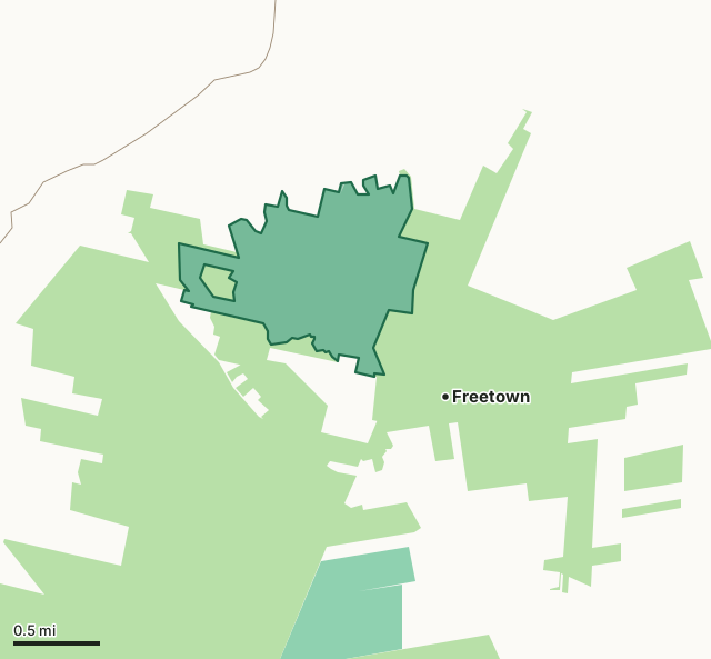
MassWildlife (Fish and Game) landState forest and park land (DCR)Mill Brook Bogs WMAZone lineHighway
| Size | 571 acres (MassWildlife) |
|---|---|
| Town | Freetown |
| County | Bristol |
| Wildlife Management Zone | Zone 11 |
| MassWildlife district | Southeast District |
| Parking (MassWildlife) | None mapped |
| Deer taken in Zone 11, 2025 | 4,153 (2,120 adult males) |
| Nearest town centers | Freetown (under a mile), Berkley (3 mi) and Lakeville (4 mi) |
What is Mill Brook Bogs WMA like?
MassWildlife describes it: "Mill Brook Bogs (formerly Freetown Swamp) WMA consists of shrub swamp, Atlantic white cedar swamp, former cranberry bogs and a large former cranberry bog reservoir, with small areas of mixed upland forest. Common vegetation on the WMA includes red maple, sweet pepperbush, highbush blueberry, leatherleaf, swamp azalea, sphagnum moss, and Atlantic white cedar, with uplands dominated by white pine, red oak, and common greenbrier. Cotton grass, sundew, and other bog plant species are also present."
On wildlife: "This WMA contains one of the largest remaining shrub swamps in southeastern Massachusetts. The property and abutting former cranberry bogs were likely once part of a much larger Atlantic white cedar swamp. Within the remaining cedar and shrub swamp there are several very large boulders left behind by receding glaciers that can clearly be seen in aerial photos. Visitors might hear Whip-poor-wills, a state listed Special Concern species, from the uplands on the eastern side of the property."
Quoted from MassWildlife's Mill Brook Bogs WMA fact sheet.
What does MassWildlife say about hunting Mill Brook Bogs WMA?
"The WMA consists primarily of a very dense shrub and Atlantic white cedar swamp, which contains an impressive diversity of plant and animal species. Game species are abundant including white-tailed deer, wild turkey, and eastern coyote. The former cranberry bogs and bog reservoir also hold abundant waterfowl seasonally. Hunting and trapping opportunities are likely very good for those individuals that take the time to walk into the WMA."
On fishing: "Fishing opportunities in the bog reservoir is limited due to shallow water depths, however typical warmwater species are present."
How do you get into Mill Brook Bogs WMA?
"The WMAs primary access point is a small gravel parking area at the north end of the property on Howland Road approximately 0.10 mile east of the intersection with Rebecca Road (adjacent to where Mill Brook crosses under Howland Road). It is also accessible through Department of Conservation and Recreation property at the Freetown-Fall River State Forest along the eastern side of Slab Bridge Road, approximately 700 feet north of the entrance to the State Forest Headquarters (old campground) or just south of the entrance to Profile Rock. Numerous unofficial and unmarked foot paths lead from the State Forest into the WMA."
MassWildlife's parking layer shows no lot for Mill Brook Bogs WMA.
Highways within five miles: MA 140, MA 24, MA 79, MA 138 and MA 18. Distances to the nearest town centers: Freetown under a mile, Berkley 3 miles, Lakeville 4 miles and Fall River 5 miles. Other WMAs nearby: Copicut (2 miles), Noquochoke (9 miles), Black Brook (9 miles).
When can you hunt deer on Mill Brook Bogs WMA in 2026?
Deer seasons follow Zone 11: archery October 5 to November 28, shotgun November 30 to December 12, primitive firearms December 14 to 31 and a winter season January 1 to 30, 2027. In 2025 the zone gave 2,139 deer to archers and 1,358 in shotgun season.
| Zone | WMA acres in it | Deer, 2025 | Adult males, 2025 | Deer, 2024 |
|---|---|---|---|---|
| Zone 11 | 576 | 4,153 | 2,120 | 3,830 |
Seasons: MassWildlife deer hunting regulations (2026 dates). Harvest: MassWildlife 2025 Deer Harvest Summary; MassWildlife 2024 Deer Harvest Summary.
What rules apply on Mill Brook Bogs WMA?
Under 321 CMR 3.01, camping, fires and target practice need the Director's written permission, vehicles stay on roads open to traffic, and dogs must be leashed unless hunting or training with a licensed hunter.
Source: MassWildlife WMA regulations.
Questions hunters ask
Can you hunt on Mill Brook Bogs WMA?
Yes. MassWildlife says all WMAs are open to hunting, fishing and trapping; deer seasons follow Zone 11, where the 2026 shotgun season runs November 30 to December 12 (MassWildlife WMA regulations).
What zone is Mill Brook Bogs WMA in?
Zone 11, as MassWildlife's fact sheet gives it. Hunters took 4,153 deer in Zone 11 in 2025, 2,120 of them adult males, after 3,830 in 2024 (MassWildlife 2025 Deer Harvest Summary).
How do you get into Mill Brook Bogs WMA?
MassWildlife's fact sheet: "The WMAs primary access point is a small gravel parking area at the north end of the property on Howland Road approximately 0.10 mile east of the intersection with Rebecca Road (adjacent to where Mill Brook crosses under Howland Road)."
What can you hunt on Mill Brook Bogs WMA?
MassWildlife's fact sheet: "The WMA consists primarily of a very dense shrub and Atlantic white cedar swamp, which contains an impressive diversity of plant and animal species. Game species are abundant including white-tailed deer, wild turkey, and eastern coyote. The former cranberry bogs and bog reservoir also hold abundant waterfowl seasonally. Hunting and trapping opportunities are likely very good for those individuals that take the time to walk into the WMA."
Get a Massachusetts hunt plan when they open
Hunt plans for Massachusetts are coming. Join the list and you'll hear first. The first 50 hunters in each new state get their plan free.
Until then, the free FilledTag app for iPhone has a map that works in every state, Massachusetts included.
Sources: MassWildlife fact sheet; MassWildlife Lands (MassGIS); MassWildlife parking for recreation; MassWildlife 2025 Deer Harvest Summary; MassWildlife deer hunting regulations (2026 dates); MassWildlife WMA regulations; public land MassGIS Protected and Recreational OpenSpace for state and Army Corps land; USGS Protected Areas Database of the United States (PAD-US 4.1) for federal land; towns U.S. Census Bureau TIGER/Line 2024 primary and secondary roads; U.S. Census Bureau 2024 Gazetteer, towns (county subdivisions). FilledTag is not part of Massachusetts Division of Fisheries and Wildlife (MassWildlife).