Squannacook River Wildlife Management Area: hunting, access and parking in Zone 9
Squannacook River Wildlife Management Area is 1,306 acres of MassWildlife land in Ashby, Groton, Shirley and Townsend (Middlesex County), in Wildlife Management Zone 9. MassWildlife says all of its WMAs are open to hunting, fishing and trapping. Hunters took 1,534 deer in Zone 9 in 2025, and MassWildlife maps 26 parking areas for the property with room for about 77 vehicles.
Data updated October 2026. Area facts: MassWildlife's Squannacook River WMA fact sheet. Harvest: MassWildlife 2025 Deer Harvest Summary. Seasons: MassWildlife deer hunting regulations (2026 dates).
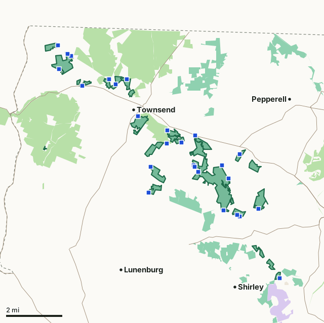
MassWildlife (Fish and Game) landState forest and park land (DCR)National wildlife refugeMilitary (closed unless the base allows)Squannacook River WMAZone lineParkingHighway
| Size | 1,306 acres (MassWildlife), in 30 pieces |
|---|---|
| Town | Ashby, Groton, Shirley and Townsend |
| County | Middlesex |
| Wildlife Management Zone | Zone 9 |
| MassWildlife district | Northeast District |
| Parking (MassWildlife) | 26 lots, about 77 spaces |
| Pheasant | Stocked; blaze orange hat required in pheasant season |
| Deer taken in Zone 9, 2025 | 1,534 (742 adult males) |
| Nearest town centers | Townsend (under a mile), Shirley (under a mile) and Ayer (2 mi) |
What is Squannacook River WMA like?
MassWildlife describes it: "Squannacook River WMA is composed of many scattered parcels. The parcels are mostly flat, valley bottom land that follow the Squannacook River from just below its origin at the confluence of Willard and Trapfall Brooks in West Townsend, downstream to just above where it flows into the Nashua River in Ayer. The area is mostly wooded. Its sandy soils support unusually fine stands of white pine interspersed with less dominant oaks and maples. There are a few open fields, in addition an abandoned power line runs from a sandpit on Harbor Road to route 225."
On wildlife: "The Squanacook River offers excellent opportunities for kayaking. Wildlife viewing is especially good along the river and within the open sand plain off of Elm Circle in Townsend. Eastern whip-poor-wills, eastern towhee, scarlet tanager, and other scrubland birds are often seen here and moose have been occasionally reported."
Quoted from MassWildlife's Squannacook River WMA fact sheet.
What does MassWildlife say about hunting Squannacook River WMA?
"American beaver, muskrat, raccoon, and waterfowl may be found along the river. There are wood duck boxes above the Route 225 dam but waterfowl hunting is limited in that area. The upland areas support small populations of ruffed grouse, white-tailed deer, red fox, and eastern coyote. Pheasants are stocked in this area. The Squannacook River is a cold water fisheries resource that receives several annual stockings of trout. It is about 30 feet wide in the section that runs through the management area. There are three dams within this stretch, one located just below Route 119 in Townsend Center, another at the junction of Harbor Road and Route 119 in Townsend, and the last one at Route 225 in Groton."
Its rules for the area: "During the pheasant season, a “hunter orange” hat is required for all hunters except while night hunting raccoons or opossums or while hunting waterfowl from within a blind or boat."
How do you get into Squannacook River WMA?
"Several areas of parking and access can be obtained from Route 119, Townsend Road, Harbor Road, Shirley Road, Meetinghouse Road, South Row Road, Elm Circle, Turnpike Road, Dudley Road, Greenville Road and Squannacook Road. See the map for details."
| Parking | Spaces | Surface | Condition | Latitude | Longitude |
|---|---|---|---|---|---|
| Dirt pull-off | 2 | Dirt | Good | 42.63652 | -71.66996 |
| Offstreet lot | 6 | Dirt | Fair | 42.63305 | -71.66662 |
| Peter Bertozzi Parking Area | 10 | Gravel | Good | 42.63641 | -71.65002 |
| Dirt pull-off | 4 | Dirt | Good | 42.65193 | -71.66901 |
| Parking | 4 | Dirt | Good | 42.65458 | -71.68814 |
| Pull-off at gate | 2 | Dirt | Good | 42.61333 | -71.64912 |
| Parking | 4 | Dirt | Good | 42.67756 | -71.74763 |
| Dirt pull-off | 2 | Dirt | Good | 42.68093 | -71.71649 |
| Parking | 2 | Dirt | Good | 42.67826 | -71.72451 |
| Parking at end of Elm Circle in front of gate | 3 | Paved | Good | 42.66177 | -71.70887 |
From MassWildlife parking for recreation.
Highways within five miles: MA 119, MA 111, MA 2, MA 13, MA 31 and MA 225. Distances to the nearest town centers: Townsend under a mile, Shirley under a mile, Ayer 2 miles and Pepperell 2 miles. Other WMAs nearby: Trapfall Brook (3 miles), Scripture Hill (5 miles), Townsend Hill (5 miles).
When can you hunt deer on Squannacook River WMA in 2026?
Deer seasons follow Zone 9: archery October 5 to November 28, shotgun November 30 to December 12, primitive firearms December 14 to 31 and a winter season January 1 to 30, 2027. In 2025 the zone gave 660 deer to archers and 557 in shotgun season.
| Zone | WMA acres in it | Deer, 2025 | Adult males, 2025 | Deer, 2024 |
|---|---|---|---|---|
| Zone 9 | 1,916 | 1,534 | 742 | 1,374 |
Seasons: MassWildlife deer hunting regulations (2026 dates). Harvest: MassWildlife 2025 Deer Harvest Summary; MassWildlife 2024 Deer Harvest Summary.
What rules apply on Squannacook River WMA?
It is stocked with pheasant, so every hunter must wear a blaze orange hat during pheasant season, except raccoon and opossum hunters at night and waterfowl hunters in a blind or boat. Under 321 CMR 3.01, camping, fires and target practice need the Director's written permission, vehicles stay on roads open to traffic, and dogs must be leashed unless hunting or training with a licensed hunter.
Source: MassWildlife WMA regulations.
Questions hunters ask
Can you hunt on Squannacook River WMA?
Yes. MassWildlife says all WMAs are open to hunting, fishing and trapping; deer seasons follow Zone 9, where the 2026 shotgun season runs November 30 to December 12 (MassWildlife WMA regulations).
What zone is Squannacook River WMA in?
Zone 9, as MassWildlife's fact sheet gives it. Hunters took 1,534 deer in Zone 9 in 2025, 742 of them adult males, after 1,374 in 2024 (MassWildlife 2025 Deer Harvest Summary).
Where do you park for Squannacook River WMA?
MassWildlife maps 26 parking areas: Dirt pull-off (about 2 cars, dirt); Offstreet lot (about 6 cars, dirt); Peter Bertozzi Parking Area (about 10 cars, gravel); Dirt pull-off (about 4 cars, dirt). Its fact sheet adds: "Several areas of parking and access can be obtained from Route 119, Townsend Road, Harbor Road, Shirley Road, Meetinghouse Road, South Row Road, Elm Circle, Turnpike Road, Dudley Road, Greenville Road and Squannacook Road. See the map for details."
What can you hunt on Squannacook River WMA?
MassWildlife's fact sheet: "American beaver, muskrat, raccoon, and waterfowl may be found along the river. There are wood duck boxes above the Route 225 dam but waterfowl hunting is limited in that area. The upland areas support small populations of ruffed grouse, white-tailed deer, red fox, and eastern coyote. Pheasants are stocked in this area. The Squannacook River is a cold water fisheries resource that receives several annual stockings of trout."
Get a Massachusetts hunt plan when they open
Hunt plans for Massachusetts are coming. Join the list and you'll hear first. The first 50 hunters in each new state get their plan free.
Until then, the free FilledTag app for iPhone has a map that works in every state, Massachusetts included.
Sources: MassWildlife fact sheet; MassWildlife Lands (MassGIS); MassWildlife parking for recreation; MassWildlife 2025 Deer Harvest Summary; MassWildlife deer hunting regulations (2026 dates); MassWildlife WMA regulations; public land MassGIS Protected and Recreational OpenSpace for state and Army Corps land; USGS Protected Areas Database of the United States (PAD-US 4.1) for federal land; towns U.S. Census Bureau TIGER/Line 2024 primary and secondary roads; U.S. Census Bureau 2024 Gazetteer, towns (county subdivisions). FilledTag is not part of Massachusetts Division of Fisheries and Wildlife (MassWildlife).