Massachusetts Zone 4S: deer harvest, antlerless permits, 2026 seasons and public land
Massachusetts's Wildlife Management Zone 4S covers 409 square miles of Hampden, Hampshire and Berkshire counties. Hunters took 479 deer there in 2025, up from 360 in 2024, against a ten-year average of 365; 361 were adult males. 9.3% of the zone is public land, the largest share state forest and park land (DCR) (17,911 acres).
Data updated October 2026. Harvest: MassWildlife 2025 Deer Harvest Summary. Seasons: MassWildlife deer hunting regulations (2026 dates). Land: MassGIS and PAD-US.
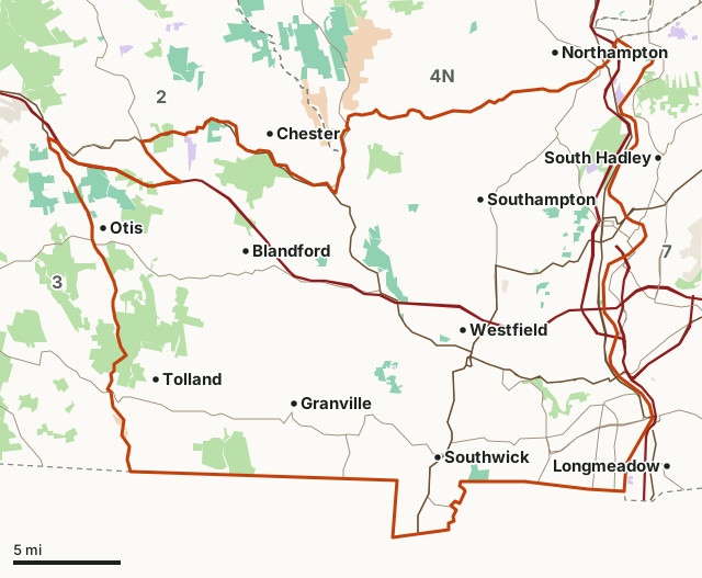
MassWildlife (Fish and Game) landState forest and park land (DCR)National wildlife refugeNational Park ServiceArmy Corps of EngineersMilitary (closed unless the base allows)Zone 4SNeighboring zonesHighway
| Size | 409 square miles |
|---|---|
| Public land | 9.3% (24,275 acres) |
| Deer taken, 2025 | 479 (361 adult males, 105 females, 13 male fawns) |
| Deer taken, 2024 | 360 |
| Average, 2016 to 2025 | 365 a year |
| Deer taken per square mile, 2025 | 1.17 (deer taken divided by the zone's area) |
| Antlerless permits, 2023 | 600 allocated |
| MassWildlife's direction for the herd | Increase |
| Extra seasons, 2026 | None beyond the statewide seasons |
| Wildlife management areas | Farmington River, Tekoa Mountain, East Mountain, Blandford |
How many deer are taken in Zone 4S each year?
479 in 2025, 119 more than in 2024. Over the ten seasons below the zone peaked at 479 in 2025 and was lowest at 304 in 2016. Adult males made up 75.4% of the 2025 harvest, against 53.7% statewide.
| Year | Adult males | Females | Male fawns | All deer |
|---|---|---|---|---|
| 2025 | 361 | 105 | 13 | 479 |
| 2024 | 279 | 71 | 10 | 360 |
| 2023 | 302 | 48 | 11 | 361 |
| 2022 | 326 | 54 | 5 | 385 |
| 2021 | 297 | 62 | 5 | 364 |
| 2020 | 318 | 43 | 6 | 367 |
| 2019 | 228 | 74 | 10 | 312 |
| 2018 | 298 | 68 | 11 | 377 |
| 2017 | 299 | 37 | 5 | 341 |
| 2016 | 247 | 53 | 4 | 304 |
Sources: MassWildlife 2025 Deer Harvest Summary; MassWildlife 2024 Deer Harvest Summary; MassWildlife 2023 Deer Harvest Summary; MassWildlife 2022 Deer Harvest Summary; MassWildlife 2021 Deer Harvest Summary; MassWildlife 2020 Deer Harvest Summary; MassWildlife 2019 Deer Harvest Summary; MassWildlife 2018 Deer Harvest Summary; MassWildlife 2017 Deer Harvest Summary; MassWildlife 2016 Deer Harvest Summary. Each year's zone rows add up to the summary's statewide row (the 2024 summary prints 8,081 adult males statewide; its zone rows add to 8,091).
Which seasons gave Zone 4S's 2025 deer?
| Season | Deer, 2025 | Share |
|---|---|---|
| Youth and paraplegic | 8 | 1.7% |
| Archery | 202 | 42.2% |
| Shotgun | 199 | 41.5% |
| Primitive firearms | 70 | 14.6% |
Source: MassWildlife 2025 Deer Harvest Summary, harvest by season and zone. The winter season of January and February 2026 is counted with the 2025 season.
How many antlerless permits does Zone 4S get?
MassWildlife allocated 600 antlerless deer permits for Zone 4S in 2023. Its management direction for the zone's deer is "Increase". Hunters apply by July 16 and may take one antlerless deer per permit, in the permit's zone only.
| Year | Antlerless permits allocated |
|---|---|
| 2023 | 600 |
| 2022 | 600 |
| 2021 | 500 |
| 2020 | 500 |
| 2019 | 500 |
| 2018 | 400 |
| 2017 | 275 |
| 2016 | 275 |
Sources: MassWildlife 2016 Deer Harvest Summary; MassWildlife 2017 Deer Harvest Summary; MassWildlife 2018 Deer Harvest Summary; MassWildlife 2019 Deer Harvest Summary; MassWildlife 2020 Deer Harvest Summary; MassWildlife 2021 Deer Harvest Summary; MassWildlife 2022 Deer Harvest Summary, antlerless deer permit allocation tables. Later summaries no longer print the table.
When are the 2026 deer seasons in Zone 4S?
| Season | Dates | Notes |
|---|---|---|
| Youth deer hunt | October 2 and 3 | Youth deer hunt permit, ages 12 to 17 |
| Archery | October 5 to November 28 | Archery stamp |
| Paraplegic hunt | October 29 to 31 | By permit |
| Shotgun | November 30 to December 12 | No stamp needed |
| Primitive firearms | December 14 to 31 | Primitive firearms stamp |
An antlered deer has at least one antler 3 inches long; licensed hunters may take two a year statewide. Shotguns no larger than 10 gauge are allowed only in shotgun season, muzzleloaders of .44 to .775 caliber in primitive season, and rifles and handguns may not be used on deer.
Source: MassWildlife deer hunting regulations (2026 dates).
How much public land is in Zone 4S?
9.3% of Zone 4S is public land: 24,275 of its 261,986 acres. The largest share is state forest and park land (DCR), 17,911 acres. MassWildlife says all of its WMAs are open to hunting; DCR forests and watershed lands have their own rules.
| Manager | Acres | Share of Zone 4S |
|---|---|---|
| State forest and park land (DCR) | 17,911 | 6.8% |
| MassWildlife (Fish and Game) land | 5,579 | 2.1% |
| National wildlife refuge | 693 | 0.3% |
| Military (closed unless the base allows) | 111 | under 0.1% |
| Army Corps of Engineers | 92 | under 0.1% |
Measured by FilledTag inside the zone line from MassGIS Protected and Recreational OpenSpace for state and Army Corps land; USGS Protected Areas Database of the United States (PAD-US 4.1) for federal land.
Wildlife management areas in Zone 4S
| WMA | Acres in Zone 4S | Town |
|---|---|---|
| Farmington River | 1,660 | Becket, Otis |
| Tekoa Mountain | 1,436 | Montgomery, Russell |
| East Mountain | 606 | Holyoke, Westfield, West Springfield |
| Blandford | 359 | |
| Southwick | 348 | Southwick |
| John J. Kelly | 327 | Chester |
| Westfield | 248 | Westfield |
| Honey Pot | 224 | Southwick, Westfield |
| Southampton | 176 | Holyoke, Southampton |
| Stage Brook | 148 | Blandford |
| Bungy Mountain | 91 | |
| Mt. Tom | 82 | Holyoke |
| Rainbow Beach | 47 | Northampton |
| Abbott Brook | 15 | Chester |
Which zones border Zone 4S?
| Zone | Square miles | Deer, 2025 | Adult males, 2025 | Public land |
|---|---|---|---|---|
| Zone 2 | 582 | 617 | 492 | 25.6% |
| Zone 3 | 422 | 706 | 419 | 17.6% |
| Zone 4N | 435 | 727 | 472 | 11.1% |
| Zone 5 | 589 | 917 | 541 | 22.9% |
| Zone 7 | 398 | 945 | 497 | 7% |
Highways crossing Zone 4S: I-90 (54 miles), MA 57 (35 miles), I-91 (32 miles), US 20 (31 miles), MA 10 (27 miles) and US 5 (27 miles). Towns inside: Blandford, Westfield, Granville and Otis.
Questions hunters ask
How many deer were taken in Massachusetts Zone 4S in 2025?
479: 361 adult males, 105 females and 13 male fawns (MassWildlife 2025 Deer Harvest Summary). By season: 202 archery, 199 shotgun, 70 primitive firearms and 8 youth and paraplegic. In 2024 the zone gave 360.
When is deer season in Zone 4S in 2026?
Archery October 5 to November 28, shotgun November 30 to December 12 and primitive firearms December 14 to 31; the youth hunt is October 2 and 3. (MassWildlife deer hunting regulations (2026 dates))
Can you get an antlerless deer permit for Zone 4S?
MassWildlife allocated 600 antlerless permits for Zone 4S in 2023, the last year its harvest summaries print, with the direction "Increase" (MassWildlife 2022 Deer Harvest Summary). Hunters apply by July 16; where demand is lower than the allocation, surplus permits go on sale in late September.
What counts as an antlered deer in Massachusetts?
A deer with at least one antler 3 inches or longer. Licensed hunters may take two antlered deer a year in any zone; any deer without antlers or with antlers under 3 inches needs an antlerless permit for the zone (MassWildlife deer hunting regulations (2026 dates)).
Get a Massachusetts hunt plan when they open
Hunt plans for Massachusetts are coming. Join the list and you'll hear first. The first 50 hunters in each new state get their plan free.
Until then, the free FilledTag app for iPhone has a map that works in every state, Massachusetts included.
Where these numbers come from
- Harvest: MassWildlife deer harvest data; MassWildlife Deer Harvest Summaries, 2016 to 2025.
- Seasons and rules: MassWildlife deer hunting regulations (2026 dates).
- Zone boundary: MassWildlife Wildlife Management Zones (MassGIS). Public land: MassGIS Protected and Recreational OpenSpace for state and Army Corps land; USGS Protected Areas Database of the United States (PAD-US 4.1) for federal land.
- Highways and towns: U.S. Census Bureau TIGER/Line 2024 primary and secondary roads; U.S. Census Bureau 2024 Gazetteer, towns (county subdivisions).
FilledTag is not part of Massachusetts Division of Fisheries and Wildlife (MassWildlife). Numbers are copied from MassWildlife, MassGIS and federal sources or measured from their maps; nothing on this page is estimated by FilledTag.