Charles River Wildlife Management Area: hunting, access and parking in Zone 9
Charles River Wildlife Management Area is 3,018 acres of MassWildlife land in Ashland, Bellingham, Boston, Dedham, Dover, Franklin, Holliston, Medfield, Medway, Millis, Needham, Norfolk, Newton, Sherborn, Walpole and Wrentham (Norfolk and Middlesex counties), in Wildlife Management Zone 9 and 10. MassWildlife says all of its WMAs are open to hunting, fishing and trapping. Hunters took 1,534 deer in Zone 9 in 2025, and MassWildlife maps 9 parking areas for the property with room for about 32 vehicles.
Data updated October 2026. Area facts: MassWildlife's Charles River WMA fact sheet. Harvest: MassWildlife 2025 Deer Harvest Summary. Seasons: MassWildlife deer hunting regulations (2026 dates).
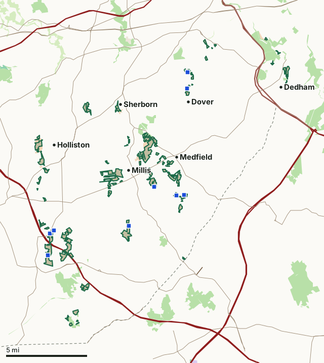
MassWildlife (Fish and Game) landState forest and park land (DCR)DCR watershed land (Quabbin, Wachusett, Ware River)National wildlife refugeArmy Corps of EngineersMilitary (closed unless the base allows)Charles River WMAZone lineParkingHighway
| Size | 3,018 acres (MassWildlife), in 99 pieces |
|---|---|
| Town | Ashland, Bellingham, Boston, Dedham, Dover, Franklin, Holliston, Medfield, Medway, Millis, Needham, Norfolk, Newton, Sherborn, Walpole and Wrentham |
| County | Norfolk, Middlesex, Suffolk |
| Wildlife Management Zone | Zone 9, Zone 10 |
| MassWildlife district | Northeast District |
| Parking (MassWildlife) | 9 lots, about 32 spaces |
| Deer taken in Zone 9, 2025 | 1,534 (742 adult males) |
| Nearest town centers | Sherborn (under a mile), Medfield (under a mile) and Dedham (under a mile) |
What is Charles River WMA like?
MassWildlife describes it: "The Charles River WMA is made up of numerous parcels within the Charles River Watershed, mainly in the upper and middle basin totaling 3017.96 acres. The WMA, managed by MassWildlife through a license agreement with US Army Corp of Engineers, is part of the Charles River Natural Valley Storage Area, a 8,095-acre flood protection area owned by US Army Corp of Engineers. The primary purpose of the Charles River Natural Valley Storage area is to reduce potential flood damage and impacts by protecting undeveloped natural water storage areas which allow the absorption of floodwater and excess precipitation. The majority of Charles River WMA parcels are made up of various types of wetland communities, such as alluvial red maple swamps, inland Atlantic white cedar, shrub swamps, emergent marshes, and floodplain forests. Upland edges are primarily shrublands, mixed hardwoods and eastern white pine. For more information about Charles River Natural Valley Storage Area, please visit the US Army Corp of Engineers website."
On wildlife: "Coyotes, fishers, beavers, beaver, river otters, waterfowl and deer utilize this property. Many bird species forage along the river, tributaries and wetlands such as herons, cormorants, Canada geese, mallards, black ducks, flycatchers and kingfishers. The Charles River watershed is used by many fish species including Massachusetts species of concern sea-run river herring and American eel."
Quoted from MassWildlife's Charles River WMA fact sheet.
What does MassWildlife say about hunting Charles River WMA?
"Hunting opportunities are dependent on a parcel-by-parcel basis; areas with sections of open water are great for waterfowl, while deer hunters should look for parcels with upland edges and islands within wetlands which provide habitat, cover and bedding for deer. Oak dominated uplands also provide ample opportunity to hunt gray squirrel. Special considerations: A person shall not take or kill a gray squirrel at any time by means of a handgun or rifle of any caliber in Zones 10 through 14."
On fishing: "Many of the Charles River WMA parcels directly abuts the Charles River or its tributaries providing access and fishing opportunity of warm water species such as bluegill, crappie, yellow perch, and large mouth bass to name a few. Trout stocking does not take place directly from Charles River WMA, though some stocked streams and rivers run through and can be accessed by the WMA. For more information on trout stocking go to mass.gov/trout."
How do you get into Charles River WMA?
"This property is dispersed in parcels across multiple municipalities. Several locations have designated parking areas for 2-6 vehicles, while other locations provide a roadside pull off for one vehicle. Note, there are several parcels that cannot be accessed from a public entry point therefore, permission to park and access must be requested from abutting private property owners."
| Parking | Spaces | Surface | Condition | Latitude | Longitude |
|---|---|---|---|---|---|
| Hartford Avenue (Rt. 126) Parking at Powerlines | 8 | Dirt/Gravel | Good | 42.11694 | -71.45852 |
| High Street Pull-off | 1 | Dirt/Grass | Good | 42.09727 | -71.46112 |
| Maple Street Pull-off | 2 | Dirt | Good | 42.11963 | -71.45403 |
| Indian hill pulloff | 4 | Paved | Excellent | 42.15028 | -71.30602 |
| Stagecoach road | 2 | Paved | Excellent | 42.15090 | -71.29689 |
| Forest road | 6 | Dirt/Gravel | Excellent | 42.15801 | -71.33287 |
| Miller street pull-off | 2 | Grass | Fair | 42.12330 | -71.36377 |
| Springdale ave pulloff | 3 | Grass | Fair | 42.24583 | -71.29274 |
| Edgewater | 4 | Paved | Excellent | 42.26063 | -71.29224 |
From MassWildlife parking for recreation.
Highways within five miles: I-95, I-495, MA 9, MA 16, MA 128 and MA 140. Distances to the nearest town centers: Sherborn under a mile, Medfield under a mile, Dedham under a mile and Dover under a mile. Other WMAs nearby: North Attleborough (12 miles), Quisset (12 miles), E. Kent Swift (14 miles).
When can you hunt deer on Charles River WMA in 2026?
Deer seasons follow Zone 9: archery October 5 to November 28, shotgun November 30 to December 12, primitive firearms December 14 to 31 and a winter season January 1 to 30, 2027. In 2025 the zone gave 660 deer to archers and 557 in shotgun season.
| Zone | WMA acres in it | Deer, 2025 | Adult males, 2025 | Deer, 2024 |
|---|---|---|---|---|
| Zone 9 | 462 | 1,534 | 742 | 1,374 |
| Zone 10 | 2,556 | 2,515 | 1,320 | 2,423 |
Seasons: MassWildlife deer hunting regulations (2026 dates). Harvest: MassWildlife 2025 Deer Harvest Summary; MassWildlife 2024 Deer Harvest Summary.
What rules apply on Charles River WMA?
Under 321 CMR 3.01, camping, fires and target practice need the Director's written permission, vehicles stay on roads open to traffic, and dogs must be leashed unless hunting or training with a licensed hunter.
Source: MassWildlife WMA regulations.
Questions hunters ask
Can you hunt on Charles River WMA?
Yes. MassWildlife says all WMAs are open to hunting, fishing and trapping; deer seasons follow Zone 9, where the 2026 shotgun season runs November 30 to December 12 (MassWildlife WMA regulations).
What zone is Charles River WMA in?
Zone 9 (462 acres) and Zone 10 (2,556 acres), as MassWildlife's fact sheet gives it. Hunters took 1,534 deer in Zone 9 in 2025, 742 of them adult males, after 1,374 in 2024 (MassWildlife 2025 Deer Harvest Summary).
Where do you park for Charles River WMA?
MassWildlife maps 9 parking areas: Hartford Avenue (Rt. 126) Parking at Powerlines (about 8 cars, dirt/gravel); High Street Pull-off (one car, dirt/grass); Maple Street Pull-off (about 2 cars, dirt); Indian hill pulloff (about 4 cars, paved). Its fact sheet adds: "This property is dispersed in parcels across multiple municipalities. Several locations have designated parking areas for 2-6 vehicles, while other locations provide a roadside pull off for one vehicle."
What can you hunt on Charles River WMA?
MassWildlife's fact sheet: "Hunting opportunities are dependent on a parcel-by-parcel basis; areas with sections of open water are great for waterfowl, while deer hunters should look for parcels with upland edges and islands within wetlands which provide habitat, cover and bedding for deer. Oak dominated uplands also provide ample opportunity to hunt gray squirrel."
Get a Massachusetts hunt plan when they open
Hunt plans for Massachusetts are coming. Join the list and you'll hear first. The first 50 hunters in each new state get their plan free.
Until then, the free FilledTag app for iPhone has a map that works in every state, Massachusetts included.
Sources: MassWildlife fact sheet; MassWildlife Lands (MassGIS); MassWildlife parking for recreation; MassWildlife 2025 Deer Harvest Summary; MassWildlife deer hunting regulations (2026 dates); MassWildlife WMA regulations; public land MassGIS Protected and Recreational OpenSpace for state and Army Corps land; USGS Protected Areas Database of the United States (PAD-US 4.1) for federal land; towns U.S. Census Bureau TIGER/Line 2024 primary and secondary roads; U.S. Census Bureau 2024 Gazetteer, towns (county subdivisions). FilledTag is not part of Massachusetts Division of Fisheries and Wildlife (MassWildlife).