Barry County, Michigan: deer harvest and public hunting land
Barry County covers 577 square miles around Hastings. Hunters reported 3,695 deer here in the 2025 license year, 1,829 of them antlered, through the DNR's harvest reporting. That is down 16% from 2024, and the fewest in the 4 years shown. 8.4% of Barry County is public land open to the public, the largest share state game and wildlife areas (21,034 acres), by USGS PAD-US 4.1 and the DNR's state forest records.
Data updated October 2026. Harvest: the DNR's reported deer totals, 2022 to 2025. Land: PAD-US 4.1, the DNR's land ownership records and its wildlife, parks, Commercial Forest and HAP layers.
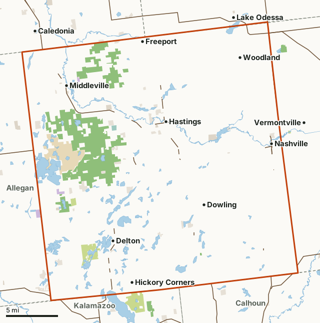
State game and wildlife areasState forest and other DNR landNational wildlife refugesState parks and recreation areasCounty, city and regional landLand trusts and other open landCommercial Forest (private, open to hunting by law)Barry CountyNeighboring countiesLakeHighway
| Size | 369,316 acres (577 square miles) |
|---|---|
| Deer reported, 2025 | 3,695 (1,829 antlered, 1,866 antlerless) |
| Regular firearm season, 2025 | 1,593 deer |
| Public land | 8.4% (30,934 acres) |
| Wildlife areas and parks | 4 (25,660 acres inside Barry County) |
| Hunting Access Program land | None mapped this year |
| Towns in and near it | Hastings, Middleville, Nashville, Lake Odessa, Caledonia and Vermontville |
How many deer are harvested in Barry County?
Hunters reported 3,695 deer in Barry County in 2025: 1,829 antlered and 1,866 antlerless. By season: 1,593 in the regular firearm season, 990 by archers (early and late segments) and 413 in the muzzleloader season.
| License year | Deer reported | Antlered | Antlerless | Regular firearm | Archery, early | Archery, late | Muzzleloader |
|---|---|---|---|---|---|---|---|
| 2025 | 3,695 | 1,829 | 1,866 | 1,593 | 951 | 39 | 413 |
| 2024 | 4,402 | 2,217 | 2,185 | 1,906 | 1,089 | 44 | 506 |
| 2023 | 4,796 | 2,668 | 2,128 | 2,235 | 1,444 | 56 | 345 |
| 2022 | 5,032 | 2,787 | 2,245 | 2,410 | 1,517 | 51 | 465 |
Source: Michigan DNR reported deer harvest (license years 2022 to 2025), Barry County. These are deer hunters reported; seasons not shown (youth, Liberty, antlerless and others) are in the total. The DNR's survey estimates, which count deer that were not reported, are higher.
How much public land is in Barry County?
30,934 of Barry County's 369,316 acres are public land open to the public (8.4%). The biggest share is state game and wildlife areas: 21,034 acres.
| Manager | Acres | Share of Barry County |
|---|---|---|
| State game and wildlife areas | 21,034 | 5.7% |
| State parks and recreation areas | 4,675 | 1.3% |
| Land trusts and other open land | 2,863 | 0.8% |
| State forest and other DNR land | 1,492 | 0.4% |
| County, city and regional land | 702 | 0.2% |
| National wildlife refuges | 159 | under 0.1% |
| National forest | 9 | under 0.1% |
| All public land open to the public | 30,934 | 8.4% |
| Commercial Forest (private, open to hunting by law) | 225 | 0.1% |
225 acres of Barry County (0.1%) are Commercial Forest land: privately owned, but under state law (MCL 324.51113) the owner may not deny the public hunting and fishing unless the DNR or the legislature closes it.
Measured by FilledTag inside the county line from USGS PAD-US 4.1 (fee land open to the public) and the DNR's land ownership records (state forest). Hunting rules differ by manager: state game areas and state forest land are open to hunting in season unless posted; national forests are open; refuges follow U.S. Fish and Wildlife Service rules; state parks and recreation areas are open, open with restrictions or closed by the DNR's map; national park land is closed to most hunting; city and county land sets its own rules.
DNR wildlife areas and parks open to hunting in Barry County
DNR wildlife areas and parks open to hunting in Barry County, largest first, with the acres of each inside it:
- Barry State Game Area: 17,393 acres
- Middleville State Game Area: 4,585 acres
- Yankee Springs Recreation Area: 3,524 acres
- Edger Waterfowl Production Area: 158 acres
Other large public areas here, by PAD-US: Lux Arbor Reserve (1,236 acres), Spring Valley (216 acres) and Barry County Waterfowl Production Area (159 acres).
How do you get to Barry County?
Highways through it: M 37 (about 12 miles inside), M 43 (about 6 miles inside), M 50 (about 3 miles inside) and M 66 (about 2 miles inside). Towns inside: Hastings, Middleville, Nashville, Woodland, Freeport and Dowling. Nearby: Lake Odessa (on the line), Caledonia (2 miles), Vermontville (2 miles) and Bellevue (3 miles).
Which counties border Barry County?
Barry County touches 6 other counties. Their latest DNR harvest and public land, for comparison:
| County | Deer harvested | Year | Public land | Hunting Access Program land sites |
|---|---|---|---|---|
| Kent County | 4,222 | 2025 | 5.5% | 1 |
| Eaton County | 5,870 | 2025 | 1% | |
| Ionia County | 6,145 | 2025 | 3.6% | 2 |
| Allegan County | 6,450 | 2025 | 10.3% | |
| Calhoun County | 5,784 | 2025 | 1.1% | 2 |
| Kalamazoo County | 3,329 | 2025 | 3.9% |
Questions hunters ask
How many deer were harvested in Barry County in 2025?
Hunters reported 3,695 deer: 1,829 antlered and 1,866 antlerless (DNR reported deer totals). In 2024: 4,402.
Is there public hunting land in Barry County?
Yes. 30,934 acres, 8.4% of the county, are public land open to the public by USGS PAD-US 4.1 and the DNR's state forest records, the largest share state game and wildlife areas (21,034 acres). The DNR's maps show 4 wildlife areas and parks open to hunting here.
Does Barry County have Hunting Access Program land?
Not on the DNR's 2026 layer of active HAP properties.
Get a Michigan hunt plan when they open
Hunt plans for Michigan are coming. Join the list and you'll hear first. The first 50 hunters in each new state get their plan free.
Until then, the free FilledTag app for iPhone has a map that works in every state, Michigan included.
Where these numbers come from
- Deer harvest: Michigan DNR reported deer harvest (license years 2022 to 2025).
- Public land: USGS PAD-US 4.1 (fee land open to the public) and the DNR's land ownership records (state forest). state game areas: Michigan DNR wildlife property project areas. Hunting Access Program land: Michigan DNR Hunting Access Program properties.
- Boundaries: U.S. Census Bureau 2024 cartographic county boundaries. Highways and towns: U.S. Census Bureau TIGER/Line 2024 primary and secondary roads; U.S. Census Bureau 2024 Gazetteer, places.
FilledTag is not part of the Michigan Department of Natural Resources. Numbers are copied from the DNR and the federal sources above, or measured from their maps; nothing on this page is estimated by FilledTag.
Michigan hunting Kent County Eaton County Ionia County Allegan County Calhoun County Kalamazoo County