Jackson County, Minnesota: public hunting land
Jackson County has 12,820 acres of public land open to the public, 2.8% of the county, the largest share state wildlife management areas (6,882 acres), by USGS PAD-US 4.1 (fee land open to the public). The DNR's map shows 30 wildlife management areas here covering 6,762 acres, the largest Timber Lake WMA (907 acres in the county). The DNR's Walk-In Access program adds 1 site of private land open to hunters, 37 acres in all. Deer here are counted by deer permit area: DPA 250 (505 deer in 2025), DPA 252 (601 deer in 2025) and DPA 238 (114 deer in 2025).
Data updated October 2026. Land: PAD-US 4.1. Wildlife Management Areas and Walk-In Access: the DNR's map layers, read 2026-10. Harvest: DNR Deer Harvest Reports, 2021 to 2025.
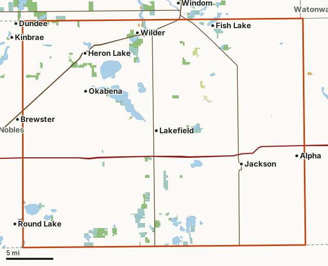
State wildlife management areasState forest and other DNR landNational wildlife refuges and waterfowl production areasState parksCounty, city and regional landWalk-In AccessJackson CountyNeighboring countiesLakeHighway
| Size | 460,326 acres (719 square miles) |
|---|---|
| Public land | 2.8% (12,820 acres) |
| WMAs | 30 (6,762 acres) |
| Walk-In Access | 1 site, 37 acres |
| Deer permit areas | DPA 250, DPA 252, DPA 238 |
| Towns | Jackson, Lakefield, Heron Lake, Wilder, Brewster and Dundee |
How much public hunting land is in Jackson County?
12,820 of the county's 460,326 acres are public land open to the public (2.8%). 12,547 acres of that are state wildlife, state forest or federal land, where hunting is the rule rather than the exception.
| Manager | Acres | Share of Jackson County |
|---|---|---|
| State wildlife management areas | 6,882 | 1.5% |
| National wildlife refuges and waterfowl production areas | 5,266 | 1.1% |
| State forest and other DNR land | 399 | 0.1% |
| State parks | 215 | under 0.1% |
| County, city and regional land | 56 | under 0.1% |
| Land trusts and other open land | 2 | under 0.1% |
| All public land open to the public | 12,820 | 2.8% |
Measured by FilledTag inside the county line from USGS PAD-US 4.1 (fee land open to the public). State wildlife management areas, state forest land and national forests are open to hunting in season; refuges and waterfowl production areas follow U.S. Fish and Wildlife Service rules; state parks allow hunting only in special hunts; national park land is closed to hunting; city and county parks set their own rules. PAD-US 4.1 leaves out most of the tax-forfeited land Minnesota counties manage, much of it open to hunting, so the public land here may be more than shown; the county land department has the maps.
The largest public areas in Jackson County by PAD-US, besides the WMAs: Jackson County Waterfowl Production Area Of Mn (5,268 acres).
Which wildlife management areas are in Jackson County?
30, largest first.
| WMA | Acres in the county | DNR lists for hunting |
|---|---|---|
| Timber Lake WMA | 907 | deer, pheasants, ducks and geese and small game |
| Heron Lake WMA | 865 | deer, pheasants, ducks and geese, mourning doves and small game |
| Sioux Valley WMA | 608 | deer, pheasants, ducks and geese and small game |
| Sangl WMA | 342 | deer, pheasants, ducks and geese and small game |
| Toe WMA | 342 | deer, pheasants, ducks and geese and small game |
| Oxbow WMA | 332 | deer, pheasants, ducks and geese and small game |
| Valleau WMA | 309 | deer, pheasants, ducks and geese, ruffed grouse and other forest upland birds and small game |
| Little Sioux WMA | 307 | deer, pheasants, ducks and geese and small game |
| Laurs Lake WMA | 266 | deer, pheasants, ducks and geese, ruffed grouse and other forest upland birds and small game |
| Cotton-Jack WMA | 254 | deer, pheasants, ducks and geese and small game |
| Skunk Lake WMA | 238 | deer, pheasants, ducks and geese and small game |
| Minneota WMA | 214 | deer, pheasants, ducks and geese and small game |
| Caraway WMA | 208 | deer, pheasants, ducks and geese and small game |
| Heron Meadows WMA | 200 | deer, pheasants, ducks and geese and small game |
| Summers WMA | 162 | deer, pheasants, ducks and geese and small game |
| Two Sheds WMA | 151 | mourning doves |
| Teal Lake WMA | 124 | deer, pheasants, ducks and geese, mourning doves and small game |
| Pletz Slough WMA | 118 | deer, pheasants, ducks and geese and small game |
| Winkler WMA | 117 | deer, pheasants, ducks and geese and small game |
| Illinois Lake WMA | 107 | deer, pheasants, ducks and geese and small game |
| Graham Creek WMA | 90 | deer, pheasants, ducks and geese and small game |
| Lillegaard WMA | 88 | pheasants, ducks and geese and small game |
| Bootleg Lake WMA | 87 | deer, pheasants, ducks and geese and small game |
| Husen WMA | 79 | deer, pheasants, ducks and geese and small game |
| Crosse WMA | 67 | deer, pheasants, ducks and geese and small game |
| Pavelko WMA | 58 | deer, pheasants, ducks and geese and small game |
| Dead Horse WMA | 40 | deer, pheasants, ducks and geese, mourning doves and small game |
| Round Lake WMA | 37 | pheasants, ducks and geese and small game |
| Libra WMA | 29 | deer, pheasants, ducks and geese and small game |
| Artz WMA | 16 | pheasants, ducks and geese and small game |
Where is the Walk-In Access in Jackson County?
The DNR's 2026 Walk-In Access layer shows 1 site in Jackson County, 37 acres of private land open to hunters with a Walk-In Access validation from September 1 to May 31: Jackson WIA #176. DNR Walk-In Access.
| Site | Acres | Location |
|---|---|---|
| Jackson WIA #176 | 37 | 43.8407, -95.204 |
Locations are the middle of each site, from the DNR's 2026 layer. Landowners may leave the program during the year; the DNR's Walk-In Access page and its site status page have the current list.
How many deer are taken in Jackson County?
The DNR counts deer by permit area, not by county. Jackson County lies in 3 permit areas; the largest share is in DPA 250 (92.4% of the county). Each figure below is for the whole permit area.
| DPA | Share of the county | Deer harvested in the whole DPA | Year |
|---|---|---|---|
| DPA 250 | 92.4% | 505 | 2025 |
| DPA 252 | 5.9% | 601 | 2025 |
| DPA 238 | 1.8% | 114 | 2025 |
Harvest: Minnesota DNR Deer Harvest Reports (2021 to 2025, 2025 report). Share of the county measured by FilledTag from the DNR's deer permit areas and the Census county line.
How do you get around Jackson County?
Highways: I-90 (about 60 miles in the county), MN 60 (about 40 miles in the county), US 71 (about 28 miles in the county), MN 86 (about 23 miles in the county) and MN 264 (about 3 miles in the county). Towns: Jackson, Lakefield, Heron Lake, Wilder, Okabena, Alpha and Fish Lake.
Questions hunters ask
What is the largest public land in Jackson County besides the WMAs?
By PAD-US 4.1: Jackson County Waterfowl Production Area Of Mn (5,268 acres in the county). The largest kind of public land here is state wildlife management areas, 6,882 acres.
What is the largest WMA in Jackson County?
Timber Lake WMA, with 907 acres inside the county. The county has 30 WMAs in all.
Does Jackson County have Walk-In Access land?
Yes. The DNR's 2026 layer shows 1 site and 37 acres in Jackson County.
Which deer permit area is Jackson County in?
DPA 250 (92.4%), DPA 252 (5.9%) and DPA 238 (1.8%). Bag limits and firearms dates follow the permit area.
Get a Minnesota hunt plan when they open
Hunt plans for Minnesota are coming. Join the list and you'll hear first. The first 50 hunters in each new state get their plan free.
Until then, the free FilledTag app for iPhone has a map that works in every state, Minnesota included.
Where these numbers come from
- Public land: USGS PAD-US 4.1 (fee land open to the public). Wildlife Management Areas: Minnesota DNR Wildlife Management Area boundaries, publicly accessible. Walk-In Access: Minnesota DNR Walk-In Access sites.
- Deer harvest: Minnesota DNR Deer Harvest Reports (2021 to 2025, 2025 report).
- County line: U.S. Census Bureau 2024 cartographic county boundaries. Highways and towns: U.S. Census Bureau TIGER/Line 2024 primary and secondary roads.
FilledTag is not part of the Minnesota Department of Natural Resources. Numbers are copied from the DNR and the federal sources above, or measured from their maps.
Minnesota hunting DPA 250 DPA 252 DPA 238 Martin County Nobles County Watonwan County Cottonwood County Walk-In Access