Minnesota Walk-In Access: sites and acres by county
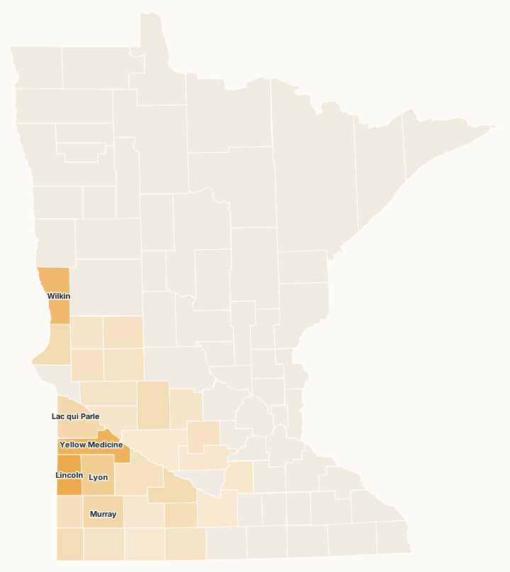
Minnesota's Walk-In Access program opens private land to public hunting. The DNR's 2026 map shows 221 sites covering 21,287 acres in 29 counties. Lincoln County has the most, 3,558 acres on 37 sites.
Data updated October 2026. Walk-In Access: the DNR's 2026 map layer, read 2026-10.
With a Walk-In Access validation on your license, you may use the sites from September 1 to May 31, from half an hour before sunrise to half an hour after sunset, without asking the landowner. All hunting laws and seasons still apply (DNR Walk-In Access program).
The DNR's rules for the sites: park on the road or in a marked lot, no motor vehicles, and no target shooting, trapping, dog training, camping, horses or fires. Sites are signed at their boundaries.
Which counties have the most Walk-In Access?
29 counties have at least one site. The most acres: Lincoln (3,558 acres), Yellow Medicine (3,129 acres), Wilkin (2,720 acres), Lyon (1,657 acres) and Murray (1,121 acres).
| County | Sites | Acres | Largest site |
|---|---|---|---|
| Lincoln County | 37 | 3,558 | Lincoln WIA #211 (192 acres) |
| Yellow Medicine County | 26 | 3,129 | Yellow Medicine WIA #867 (585 acres) |
| Wilkin County | 20 | 2,720 | Wilkin WIA #315 (439 acres) |
| Lyon County | 19 | 1,657 | Lyon WIA #858 (176 acres) |
| Murray County | 12 | 1,121 | Murray WIA #150 (236 acres) |
| Lac qui Parle County | 12 | 1,036 | Lac qui Parle WIA #989 (161 acres) |
| Brown County | 11 | 875 | Brown WIA #323 (153 acres) |
| Traverse County | 7 | 746 | Traverse WIA #820 (177 acres) |
| Rock County | 8 | 732 | Rock WIA #857 (171 acres) |
| Kandiyohi County | 8 | 727 | Kandiyohi WIA #236 (214 acres) |
| Watonwan County | 8 | 679 | Watonwan WIA #639 (428 acres) |
| Pipestone County | 5 | 517 | Pipestone WIA #226 (167 acres) |
| Redwood County | 6 | 437 | Brown WIA #323 (152 acres) |
| Stevens County | 6 | 424 | Stevens WIA #791 (115 acres) |
| Douglas County | 4 | 363 | Douglas WIA #291 (149 acres) |
| McLeod County | 4 | 340 | McLeod WIA #615 (136 acres) |
| Martin County | 4 | 302 | Martin WIA #715 (176 acres) |
| Pope County | 4 | 291 | Pope WIA #1058 (149 acres) |
| Swift County | 2 | 280 | Swift WIA #432 (233 acres) |
| Nobles County | 3 | 264 | Nobles WIA #934 (130 acres) |
| Meeker County | 3 | 203 | Meeker WIA #717 (103 acres) |
| Grant County | 2 | 202 | Grant WIA #719 (142 acres) |
| Chippewa County | 2 | 191 | Chippewa WIA #823 (119 acres) |
| Le Sueur County | 2 | 157 | Le Sueur WIA #802 (96 acres) |
| Cottonwood County | 3 | 106 | Cottonwood WIA #249 (60 acres) |
| Sibley County | 1 | 101 | Sibley WIA #774 (101 acres) |
| Blue Earth County | 1 | 49 | Blue Earth WIA #1001 (49 acres) |
| Renville County | 1 | 38 | Renville WIA #694 (38 acres) |
| Jackson County | 1 | 37 | Jackson WIA #176 (37 acres) |
Sites and acres measured by FilledTag inside each county line from Minnesota DNR Walk-In Access sites. A site that crosses a county line is counted in each county it touches.
Questions hunters ask
How many Walk-In Access sites does Minnesota have?
The DNR's 2026 layer shows 221 sites and 21,287 acres, in 29 counties.
Which county has the most Walk-In Access land?
Lincoln County, with 3,558 acres on 37 sites, then Yellow Medicine (3,129 acres), Wilkin (2,720 acres) and Lyon (1,657 acres).
When can you hunt Walk-In Access land in Minnesota?
September 1 to May 31, from half an hour before sunrise to half an hour after sunset, with a Walk-In Access validation and the license for the season you hunt.
Get a Minnesota hunt plan when they open
Hunt plans for Minnesota are coming. Join the list and you'll hear first. The first 50 hunters in each new state get their plan free.
Until then, the free FilledTag app for iPhone has a map that works in every state, Minnesota included.
Sources: Minnesota DNR Walk-In Access sites; the DNR's Walk-In Access program. FilledTag is not part of the Minnesota Department of Natural Resources.