Bergo Wildlife Management Area: hunting and access
Bergo Wildlife Management Area is 189 acres of state land managed by the Minnesota DNR in Chippewa County, near Watson, inside Deer Permit Area 278. The DNR's WMA data lists deer, wild turkey, pheasants, ducks and geese, mourning doves and small game for it. Hunters registered 639 deer in DPA 278 in 2025.
Data updated October 2026. Area facts: the DNR's wildlife management area data, read 2026-10. Harvest: DNR Deer Harvest Reports, 2021 to 2025.
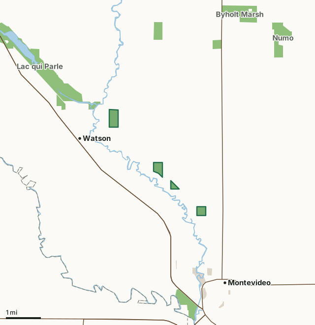
State wildlife management areasCounty, city and regional landBergo WMACounty lineLakeHighway
| Size | 189 acres in 4 pieces |
|---|---|
| County | Chippewa County |
| Deer Permit Area | DPA 278 |
| DNR lists for hunting | deer, wild turkey, pheasants, ducks and geese, mourning doves and small game |
| Nearest town (DNR) | Watson |
| DNR area office | New London |
| Special restrictions | Yes, see the rules below |
| Nearest towns | Watson (next to it), Montevideo (2 mi) and Milan (9 mi) |
What is Bergo WMA like?
The original NW parcel was acquired in 2020. A 97.7 acre addition on the south end was added in 2026. The tract lies only 1/4 mile to the SE terminus of the Lac qui Parle WMA (Watson Sag) unit. The parcel is a key addition as a habitat bridge to connect the large WMA complex to the NW to small "satellite WMAs" to the SE, all of which are parcels of Bergo WMA. This unit was purchased in 2020 with Federal funds targeting acquisition and management of habitat for the Federally threatened Dakota Skipper butterfly. This portion of Bergo WMA was purchased in 2020 with Federal funding targeting the acquisition and management of habitat for the Federally threatened Dakota Skipper butterfly. This 50.7 acre WMA is lowland brush, wet remnant prairie, reconstructed (seeded) prairie, and wetland.
The unit consists of a small former agricultural field in the NE, non-native smooth brome grass to the west of that field, and remnant native wet prairie on the southern 3/4 of the WMA. It is an excellent pheasant hunting WMA, and a haven for non-game grassland songbirds. The primary management goal is to maintain the diversity and vigor of the prairie and wetlands. The floodplain forest along the Chippewa River on the south end is largely managed naturally through periodic flooding. This subunit is an isolated 40 acre parcel just north of Montevideo in the Chippewa River bottoms. The parcel lies on flat floodplain ground, but it is dry most, if not all, of the year. The unit contains remnant native prairie, some pockets of introduced grasses, an old dugout pond once used for cattle watering hole, and an emergent wetland in the NE.
In the DNR's words, from its wildlife management area data.
What can you hunt on Bergo WMA?
The DNR's WMA data lists deer, wild turkey, pheasants, ducks and geese, mourning doves and small game for Bergo WMA. Each follows the statewide season and, for deer, the bag limit of the permit area.
What are the rules on Bergo WMA?
Open to hunting and trapping in the regular seasons under the DNR's statewide WMA rules.
Special restriction the DNR lists for Bergo WMA: No hunting/discharge of firearms is allowed on the access trail.
How many deer are taken around Bergo WMA?
Bergo WMA lies in Deer Permit Area 278. The DNR registered 639 deer in DPA 278 in 2025, against 624 in 2024.
| DPA | Bergo WMA acres in it | Deer, 2025 | Deer, 2024 | Deer, 2023 |
|---|---|---|---|---|
| DPA 278 | 189 | 639 | 624 | 580 |
Harvest for the whole deer permit area, not the WMA alone: Minnesota DNR Deer Harvest Reports (2021 to 2025, 2025 report).
How do you get to Bergo WMA?
From Watson, MN travel 1 mile NW on MN 7. Take a right and travel east on Chippewa CR 13 for 1.85 miles to arrive at the parking lot on the south (right) side of the road. From the west end of Montevideo (Smith addition) take Town Road / 70th Ave. SW to the north for 2.1 miles to a field road access trail on the north end of the residential grove. Take a right and park. Walk in access is along the winding access easement corridor. It is a 1/4 mile walk to get to the SW corner of this 40 acre tract. From the west end of Montevideo (Smith addition), take Town Road / 70th Ave. SW north for 2.75 miles. Take a left (go west) on unmarked Minimum Maintenance Township Cartway and travel west for 0.25 miles to the unit. From the junction of MN 7 and MN 29 go N on #29 4 miles then west on twp. gravel rd 2 miles, then left on cartway.5 miles to NE corner of unit.
Parking lots are in the NE corner, and on the south end. Access trail and WMA will be surveyed in the spring of 2021. The access is not yet marked. Do NOT follow the field road next to the rural residence that heads east. A different (new) access trail will be developed north of the rock outcrop / grove. Access is by way of a Minimum Maintenance Township cartway. Take care to avoid travel on the road during wet conditions.
Nearest towns: Watson (next to it), Montevideo (2 miles), Milan (9 miles) and Boyd (12 miles). Highways within 5 miles: MN 7, US 59, MN 29 and US 212.
What other public land is near Bergo WMA?
DNR WMAs within 10 miles:
- Lac qui Parle WMA: 33,602 acres, next to it
- Tunsberg WMA: 81 acres, 2.3 miles away
- Byholt Marsh WMA: 283 acres, 3.2 miles away
- Benderberg WMA: 427 acres, 3.4 miles away
- Clair T. Rollings Chippewa Co. WMA: 121 acres, 4 miles away
- Numo WMA: 207 acres, 4.4 miles away
Public land within 3 miles of Bergo WMA
Counting Bergo WMA itself, 1,119 of the 35,260 acres within 3 miles of its boundary are public land open to the public (3.2%), by USGS PAD-US 4.1 (fee land open to the public).
| Manager | Acres within 3 miles |
|---|---|
| State wildlife management areas | 1,017 |
| County, city and regional land | 102 |
Questions hunters ask
Where is Bergo WMA?
In Chippewa County, near Watson. The DNR's directions: From Watson, MN travel 1 mile NW on MN 7. Take a right and travel east on Chippewa CR 13 for 1.85 miles to arrive at the parking lot on the south (right) side of the road. From the west end of Montevideo (Smith addition) take Town Road / 70th Ave. SW to the north for 2.1 miles to a field road access trail on the north end of the residential grove. Take a right and park. Walk in access is along the winding access easement corridor. It is a 1/4 mile walk to get to the SW corner of this 40 acre tract. From the west end of Montevideo (Smith addition), take Town Road / 70th Ave. SW north for 2.75 miles. Take a left (go west) on unmarked Minimum Maintenance Township Cartway and travel west for 0.25 miles to the unit. From the junction of MN 7 and MN 29 go N on #29 4 miles then west on twp. gravel rd 2 miles, then left on cartway.5 miles to NE corner of unit.
Which deer permit area is Bergo WMA in?
Deer Permit Area 278. Its bag limit and firearms dates apply.
How much public land is around Bergo WMA?
1,119 acres within 3 miles of its boundary, Bergo WMA included, by PAD-US 4.1. 6 other WMAs are within 10 miles, the closest Lac qui Parle WMA (next to it).
Get a Minnesota hunt plan when they open
Hunt plans for Minnesota are coming. Join the list and you'll hear first. The first 50 hunters in each new state get their plan free.
Until then, the free FilledTag app for iPhone has a map that works in every state, Minnesota included.
Where these facts come from
- Area description, species, rules and directions: DNR, Bergo WMA; Minnesota DNR Wildlife Management Area boundaries, publicly accessible.
- Boundary and acres: the DNR's map layer above. Surrounding public land: USGS PAD-US 4.1 (fee land open to the public).
- Deer harvest: Minnesota DNR Deer Harvest Reports (2021 to 2025, 2025 report).
FilledTag is not part of the Minnesota Department of Natural Resources. Check the DNR's rules and posted signs before you go.