Lac qui Parle Wildlife Management Area: hunting and access
Lac qui Parle Wildlife Management Area is 33,602 acres of state land managed by the Minnesota DNR in Lac qui Parle, Chippewa, Big Stone and Swift counties, near Watson, inside Deer Permit Areas 278 and 274. The DNR's WMA data lists deer, wild turkey, pheasants, ducks and geese, mourning doves and small game for it. Hunters registered 639 deer in DPA 278 in 2025.
Data updated October 2026. Area facts: the DNR's wildlife management area data, read 2026-10. Harvest: DNR Deer Harvest Reports, 2021 to 2025.
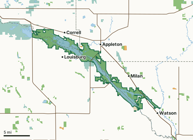
State wildlife management areasNational wildlife refuges and waterfowl production areasState parksCounty, city and regional landWalk-In AccessLac qui Parle WMACounty lineLakeHighway
| Size | 33,602 acres in 5 pieces |
|---|---|
| Counties | Lac qui Parle County, Chippewa County, Big Stone County and Swift County |
| Deer Permit Area | DPA 278, DPA 274 |
| DNR lists for hunting | deer, wild turkey, pheasants, ducks and geese, mourning doves and small game |
| Nearest town (DNR) | Watson |
| DNR area office | Lac qui Parle |
| Special restrictions | Yes, see the rules below |
| Nearest towns | Correll (next to it), Watson (next to it) and Louisburg (next to it) |
What is Lac qui Parle WMA like?
The Lac qui Parle Refuge (Controlled Hunting Zone) lies in the Upper Minnesota River Valley with the refuge boundary surrounding lower Lac qui Parle Lake. The refuge is a mixture of cropland, seasonal and permanent wetlands, and scattered grasslands. Lac qui Parle WMA lies in the Upper Minnesota River Valley with Lac qui Parle Lake (5,600 acres) and Marsh Lake (5,000 acres) being the prominent features. Large tracts of native prairie interspersed with numerous wetland basins surround both lakes.
The refuge is managed as a feeding and resting area for migratory waterfowl. Peak numbers of 150,000 Canada geese and 20,000 mallards are recorded. Cropland management is a priority to ensure sufficient food exists for migratory bird species. The main purpose of the WMA is to manage and preserve a functioning prairie pothole landscape. Food plots are dispersed throughout the unit to provide a food source for resident and migratory wildlife. Canada goose hunting is the main recreational activity; 112 public goose hunting blinds available. As many as 50 bald eagles use the refuge during the fall and a few nest here. Lac qui Parle State Park is located just south of the WMA headquarters.There are 19 Accessible Blinds within the Controlled Hunting Zone. Hunting opportunities include waterfowl, pheasants, deer, and small game.
In the DNR's words, from its wildlife management area data.
What can you hunt on Lac qui Parle WMA?
The DNR's WMA data lists deer, wild turkey, pheasants, ducks and geese, mourning doves and small game for Lac qui Parle WMA. Each follows the statewide season and, for deer, the bag limit of the permit area.
What are the rules on Lac qui Parle WMA?
Open to hunting and trapping in the regular seasons under the DNR's statewide WMA rules.
Special restriction the DNR lists for Lac qui Parle WMA: Lac qui Parle Game Refuge-Waterfowl hunting allowed at designated hunting stations only from Oct. 17 through the end of the goose season. Small game other than waterfowl may not be taken from Oct. 12 through Nov. 30. Small game hunting, including wild turkey, is otherwise allowed during open seasons. Deer hunting is also allowed on the refuge. The following regulations apply to designated hunting stations in game refuges. -Hunters must use designated hunting stations on a first come, first served basis. -no person may park in or otherwise occupy any parking lot or occupy any hunting station from 10p.m to 5 a.m. -General regulations for wildlife management area and state game refuges apply to hunters who are using designated hunting stations. Hunters must also comply with all other waterfowl and general hunting regulations. -No person may leave any refuse, offal, or feathers on public lands in the the controlled hunting zone or in any parking lot or designated overnight use area on the management area. -No alcoholic beverages may be consumed or possessed at any of the hunting stations on public lands. See Minnesota Waterfowl Hunting Regulations for complete list of General hunting regulations and restrictions.
Special restriction the DNR lists for Lac qui Parle WMA: The eastern one-half of Marsh Lake is non-motorized during open waterfowl seasons. The entire WMA is closed from 10:00 p.m. to 5:00 a.m. Trappers must obtain a permit from the wildlife area manager.
Lac qui Parle WMA is one of the WMAs where every trapper needs a permit from the area wildlife manager.
Lac qui Parle WMA has accessible duck or goose hunting blinds for hunters with mobility issues.
How many deer are taken around Lac qui Parle WMA?
Lac qui Parle WMA lies in 2 deer permit areas. The DNR registered 639 deer in DPA 278 in 2025, against 624 in 2024.
| DPA | Lac qui Parle WMA acres in it | Deer, 2025 | Deer, 2024 | Deer, 2023 |
|---|---|---|---|---|
| DPA 278 | 33,598 | 639 | 624 | 580 |
| DPA 274 | 4 | 495 | 453 | 402 |
Harvest for the whole deer permit area, not the WMA alone: Minnesota DNR Deer Harvest Reports (2021 to 2025, 2025 report).
How do you get to Lac qui Parle WMA?
Lac qui Parle WMA is between Appleton and Montevideo. Take Hwy. 7 & 59 north of Montevideo for 7 miles. Turn west on Co. Rd. 13 for 2.5 miles. Go north on Co. Rd. 32 for 2 miles, then west on Co. Rd. 33 for ½ mile to reach the WMA headquarters.
All access points have high water. The Hwy 119 access is presently not usable due to high water. The Killen Access is closed until conditions improve. Use caution on WMA and area roads. Rain and flooding has caused gravel surfaces to erode on slopes and where water has gone over the road. Water in ditches can be quite deep. Any off road travel is treacherous due to wet soil conditions. The WMA has over 60 parking lots and/or water accesses located throughout the unit. Wheelchair access is considered difficult on the WMA and moderate along the gravel shoulders of adjacent county roads.
Nearest towns: Correll (next to it), Watson (next to it), Louisburg (next to it) and Appleton (next to it). Highways within 5 miles: MN 7, US 59, MN 119, US 75 and US 12. 1 Walk-In Access site within 3 miles.
What other public land is near Lac qui Parle WMA?
DNR WMAs within 10 miles:
- Pyramid WMA: 20 acres, next to it
- Bergo WMA: 189 acres, next to it
- Red Buffalo WMA: 108 acres, 1 mile away
- Clair T. Rollings Chippewa Co. WMA: 121 acres, 1.6 miles away
- Benderberg WMA: 427 acres, 1.6 miles away
- Milan WMA: 447 acres, 1.9 miles away
Public land within 3 miles of Lac qui Parle WMA
Counting Lac qui Parle WMA itself, 43,675 of the 187,315 acres within 3 miles of its boundary are public land open to the public (23.3%), by USGS PAD-US 4.1 (fee land open to the public).
| Manager | Acres within 3 miles |
|---|---|
| State wildlife management areas | 35,318 |
| National wildlife refuges and waterfowl production areas | 7,767 |
| State parks | 590 |
Questions hunters ask
Where is Lac qui Parle WMA?
In Lac qui Parle, Chippewa, Big Stone and Swift counties, near Watson. The DNR's directions: Lac qui Parle WMA is between Appleton and Montevideo. Take Hwy. 7 & 59 north of Montevideo for 7 miles. Turn west on Co. Rd. 13 for 2.5 miles. Go north on Co. Rd. 32 for 2 miles, then west on Co. Rd. 33 for ½ mile to reach the WMA headquarters.
Which deer permit area is Lac qui Parle WMA in?
DPA 278 (33,598 acres) and DPA 274 (4 acres). Each part follows its own permit area's bag limit.
How much public land is around Lac qui Parle WMA?
43,675 acres within 3 miles of its boundary, Lac qui Parle WMA included, by PAD-US 4.1. 6 other WMAs are within 10 miles, the closest Pyramid WMA (next to it).
Get a Minnesota hunt plan when they open
Hunt plans for Minnesota are coming. Join the list and you'll hear first. The first 50 hunters in each new state get their plan free.
Until then, the free FilledTag app for iPhone has a map that works in every state, Minnesota included.
Where these facts come from
- Area description, species, rules and directions: DNR, Lac qui Parle WMA; Minnesota DNR Wildlife Management Area boundaries, publicly accessible.
- Boundary and acres: the DNR's map layer above. Surrounding public land: USGS PAD-US 4.1 (fee land open to the public).
- Deer harvest: Minnesota DNR Deer Harvest Reports (2021 to 2025, 2025 report).
FilledTag is not part of the Minnesota Department of Natural Resources. Check the DNR's rules and posted signs before you go.
Minnesota hunting Lac qui Parle County Chippewa County Big Stone County Swift County DPA 278 DPA 274