Faribault Wildlife Management Area: hunting and access
Faribault Wildlife Management Area is 681 acres of state land managed by the Minnesota DNR in Rice and Steele counties, near Faribault, inside Deer Permit Area 293. The DNR's WMA data lists deer, wild turkey, pheasants, ducks and geese, mourning doves and small game for it. Hunters registered 775 deer in DPA 293 in 2025.
Data updated October 2026. Area facts: the DNR's wildlife management area data, read 2026-10. Harvest: DNR Deer Harvest Reports, 2021 to 2025.
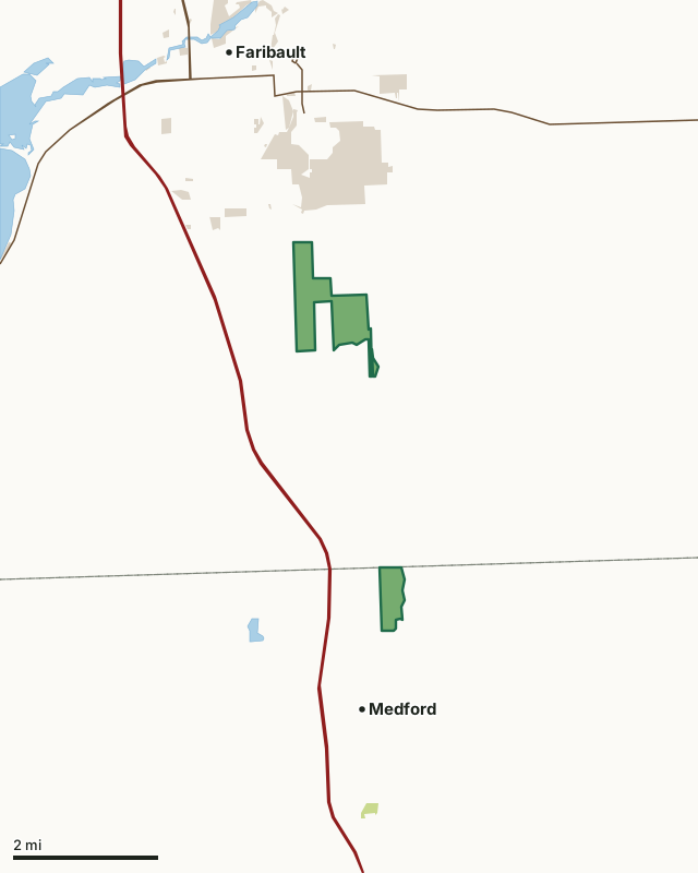
State wildlife management areasState forest and other DNR landCounty, city and regional landFaribault WMACounty lineLakeHighway
| Size | 681 acres in 3 pieces |
|---|---|
| Counties | Rice County and Steele County |
| Deer Permit Area | DPA 293 |
| DNR lists for hunting | deer, wild turkey, pheasants, ducks and geese, mourning doves and small game |
| Nearest town (DNR) | Faribault |
| DNR area office | Owatonna |
| Nearest towns | Medford (next to it), Faribault (3 mi) and Warsaw (6 mi) |
What is Faribault WMA like?
This WMA is composed of fields planted to grassland, food plots and tree and shrub windbreaks. Small woodlots of elm and boxelder provide hardwood cover. Management efforts use prescribed burns and farming as tools for creating a mosaic of habitats.
Management for this WMA emphasizes small game and grassland wildlife management. Habitat objectives include increasing prairie, grassland and brushland habitats through restorations of old fields to more productive cover. Good year-round bird watching. This WMA offers good opportunities for upland game and white-tailed deer. Ring-necked pheasants, wild turkeys, mourning doves, cottontail rabbits and raccoons are the most common small game. Waterfowl and other wetland wildlife are associated with the Straight River and small ponds found on the unit. The WMA also provides shore fishing access to the river. The Straight River Canoeing and Boating Route and Krogh Landing flank the east arm of the WMA. Much history is associated with this area which encompasses part of the town site of Walcott and the Grand View State Farm.
In the DNR's words, from its wildlife management area data.
What can you hunt on Faribault WMA?
The DNR's WMA data lists deer, wild turkey, pheasants, ducks and geese, mourning doves and small game for Faribault WMA. Each follows the statewide season and, for deer, the bag limit of the permit area.
What are the rules on Faribault WMA?
Open to hunting and trapping in the regular seasons under the DNR's statewide WMA rules.
How many deer are taken around Faribault WMA?
Faribault WMA lies in Deer Permit Area 293. The DNR registered 775 deer in DPA 293 in 2025, against 711 in 2024.
| DPA | Faribault WMA acres in it | Deer, 2025 | Deer, 2024 | Deer, 2023 |
|---|---|---|---|---|
| DPA 293 | 681 | 775 | 711 | 781 |
Harvest for the whole deer permit area, not the WMA alone: Minnesota DNR Deer Harvest Reports (2021 to 2025, 2025 report).
How do you get to Faribault WMA?
From Faribault go 1 mile S. on Albert Avenue (Co. Rd. 45), then 0.5 miles E. on 230th Street East. The address is 2851 235th Street East. Travel 1 mile north on County Road 45 to Cabot Avenue (County Road 49) then east and north on Cabot Avenue to Northwest 86th Street. Take NW 86th Street to the east across the rail road. A gravel topped parking area is located just east of the rail crossing on the south side of the road.
A gravel parking area is located at south of 235th Street East about a tenth mile west of the intersection with County Highway 19 (Glynview Trail/Cabot Avenue). A second parking area is located in the southwest corner of the WMA on the east side of Babcock Avenue.
Nearest towns: Medford (next to it), Faribault (3 miles), Warsaw (6 miles) and Owatonna (6 miles). Highways within 5 miles: I-35, MN 60, MN 21 and MN 3.
What other public land is near Faribault WMA?
DNR WMAs within 10 miles:
- Cannon River Trout Lily WMA: 129 acres, 4 miles away
- Prairie Rose WMA: 118 acres, 4.3 miles away
- Sunktokeca Creek WMA: 202 acres, 5.6 miles away
- Dwyer WMA: 56 acres, 5.7 miles away
- Swan WMA: 238 acres, 6 miles away
- Cannon River WMA: 270 acres, 6.6 miles away
Public land within 3 miles of Faribault WMA
Counting Faribault WMA itself, 1,703 of the 42,360 acres within 3 miles of its boundary are public land open to the public (4%), by USGS PAD-US 4.1 (fee land open to the public).
| Manager | Acres within 3 miles |
|---|---|
| County, city and regional land | 1,002 |
| State wildlife management areas | 682 |
| State forest and other DNR land | 19 |
Questions hunters ask
Where is Faribault WMA?
In Rice and Steele counties, near Faribault. The DNR's directions: From Faribault go 1 mile S. on Albert Avenue (Co. Rd. 45), then 0.5 miles E. on 230th Street East. The address is 2851 235th Street East. Travel 1 mile north on County Road 45 to Cabot Avenue (County Road 49) then east and north on Cabot Avenue to Northwest 86th Street. Take NW 86th Street to the east across the rail road. A gravel topped parking area is located just east of the rail crossing on the south side of the road.
Which deer permit area is Faribault WMA in?
Deer Permit Area 293. Its bag limit and firearms dates apply.
How much public land is around Faribault WMA?
1,703 acres within 3 miles of its boundary, Faribault WMA included, by PAD-US 4.1. 6 other WMAs are within 10 miles, the closest Cannon River Trout Lily WMA (4 miles).
Get a Minnesota hunt plan when they open
Hunt plans for Minnesota are coming. Join the list and you'll hear first. The first 50 hunters in each new state get their plan free.
Until then, the free FilledTag app for iPhone has a map that works in every state, Minnesota included.
Where these facts come from
- Area description, species, rules and directions: DNR, Faribault WMA; Minnesota DNR Wildlife Management Area boundaries, publicly accessible.
- Boundary and acres: the DNR's map layer above. Surrounding public land: USGS PAD-US 4.1 (fee land open to the public).
- Deer harvest: Minnesota DNR Deer Harvest Reports (2021 to 2025, 2025 report).
FilledTag is not part of the Minnesota Department of Natural Resources. Check the DNR's rules and posted signs before you go.