Cannon River Wildlife Management Area: hunting and access
Cannon River Wildlife Management Area is 270 acres of state land managed by the Minnesota DNR in Rice County, near Morristown, inside Deer Permit Area 292. The DNR's WMA data lists deer, wild turkey, pheasants, ducks and geese, mourning doves and small game for it. Hunters registered 1,197 deer in DPA 292 in 2025.
Data updated October 2026. Area facts: the DNR's wildlife management area data, read 2026-10. Harvest: DNR Deer Harvest Reports, 2021 to 2025.
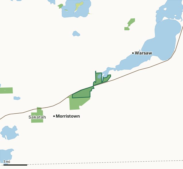
State wildlife management areasState forest and other DNR landCounty, city and regional landCannon River WMACounty lineLakeHighway
| Size | 270 acres in 2 pieces |
|---|---|
| County | Rice County |
| Deer Permit Area | DPA 292 |
| DNR lists for hunting | deer, wild turkey, pheasants, ducks and geese, mourning doves and small game |
| Nearest town (DNR) | Morristown |
| DNR area office | Owatonna |
| Nearest towns | Morristown (next to it), Warsaw (next to it) and Faribault (7 mi) |
What is Cannon River WMA like?
This WMA is a complex comprised of floodplain forest with marshy lake, wet meadow and grassy upland areas. The Sakatah Singing Hills Trail passes through the WMA and the Cannon River Aquatic Management Area adjoins the WMA on the south and west. This tract is comprised of gently rolling land and marshy river and lake shore, wet meadows and shrub swamps where the Cannon River flows to Cannon Lake. Upland habitats are brushy grasslands with some small woodlots.
Management emphasis on this WMA includes upland game and waterfowl habitat, river corridor and lakeshore protection. This tract was donated by Lottie West in cooperation with the Nature Conservancy in memory of Lottie's husband, Thomas, so the special natural features of this area could be conserved. Much of the initial upland habitat development was accomplished through the Reinvest in Minnesota program. The area is managed for indigenous wildlife that require upland brush and riparian habitats. Management techniques such as prescribed burns, mowing and cutting invasive trees are used to maintain productive cover types. Please be aware of the proximity of nearby residences and respect private land. Sakatah Singing Hills State Trail and Cannon River Canoe Route pass through the WMA.
In the DNR's words, from its wildlife management area data.
What can you hunt on Cannon River WMA?
The DNR's WMA data lists deer, wild turkey, pheasants, ducks and geese, mourning doves and small game for Cannon River WMA. Each follows the statewide season and, for deer, the bag limit of the permit area.
What are the rules on Cannon River WMA?
Open to hunting and trapping in the regular seasons under the DNR's statewide WMA rules.
How many deer are taken around Cannon River WMA?
Cannon River WMA lies in Deer Permit Area 292. The DNR registered 1,197 deer in DPA 292 in 2025, against 1,149 in 2024.
| DPA | Cannon River WMA acres in it | Deer, 2025 | Deer, 2024 | Deer, 2023 |
|---|---|---|---|---|
| DPA 292 | 270 | 1,197 | 1,149 | 1,088 |
Harvest for the whole deer permit area, not the WMA alone: Minnesota DNR Deer Harvest Reports (2021 to 2025, 2025 report).
How do you get to Cannon River WMA?
From Morristown go 1 mile E. on Hwy. 60. The Thomas West Tract of Cannon River WMA is adjacent to Warsaw along Fosston Avenue.
A small, grass surface parking area is located near the west end of the Wildlife Management Area on the south side of Highway 60. Portions of the wildlife area south of the Cannon River may be accessed through the adjacent Cannon River Aquatic Management Area. A parking lot for the Aquatic Management Area is located near the south end of the unit on the west side of Hamel Trail. There are no formal parking areas on this portion of the wildlife area north of Highway 60. The Sakatah Trail borders the south side and Fosston Avenue bounds the southeast side of the Thomas West tract. The section of this area north of Cannon Lake is accessed by a short foot path south of Harris Trail. This foot path is about 0.3 miles southwest of the intersection of Garfield Avenue and Harris Trail. Off road parking is available for the portion of Cannon River WMA located south of Highway 60 and small parking areas are available for the Sakatah Singing Hills State Trail.
Nearest towns: Morristown (next to it), Warsaw (next to it), Faribault (7 miles) and Waterville (7 miles). Highways within 5 miles: MN 60.
What other public land is near Cannon River WMA?
DNR WMAs within 10 miles:
- Sakatah WMA: 212 acres, 1.3 miles away
- Dwyer WMA: 56 acres, 2 miles away
- Pawek WMA: 79 acres, 6 miles away
- Faribault WMA: 681 acres, 6.6 miles away
- Boyd Sartell WMA: 1,367 acres, 6.7 miles away
- Sunktokeca Creek WMA: 202 acres, 7.3 miles away
Public land within 3 miles of Cannon River WMA
Counting Cannon River WMA itself, 840 of the 26,686 acres within 3 miles of its boundary are public land open to the public (3.1%), by USGS PAD-US 4.1 (fee land open to the public).
| Manager | Acres within 3 miles |
|---|---|
| State wildlife management areas | 789 |
| State forest and other DNR land | 44 |
| County, city and regional land | 7 |
Questions hunters ask
Where is Cannon River WMA?
In Rice County, near Morristown. The DNR's directions: From Morristown go 1 mile E. on Hwy. 60. The Thomas West Tract of Cannon River WMA is adjacent to Warsaw along Fosston Avenue.
Which deer permit area is Cannon River WMA in?
Deer Permit Area 292. Its bag limit and firearms dates apply.
How much public land is around Cannon River WMA?
840 acres within 3 miles of its boundary, Cannon River WMA included, by PAD-US 4.1. 6 other WMAs are within 10 miles, the closest Sakatah WMA (1.3 miles).
Get a Minnesota hunt plan when they open
Hunt plans for Minnesota are coming. Join the list and you'll hear first. The first 50 hunters in each new state get their plan free.
Until then, the free FilledTag app for iPhone has a map that works in every state, Minnesota included.
Where these facts come from
- Area description, species, rules and directions: DNR, Cannon River WMA; Minnesota DNR Wildlife Management Area boundaries, publicly accessible.
- Boundary and acres: the DNR's map layer above. Surrounding public land: USGS PAD-US 4.1 (fee land open to the public).
- Deer harvest: Minnesota DNR Deer Harvest Reports (2021 to 2025, 2025 report).
FilledTag is not part of the Minnesota Department of Natural Resources. Check the DNR's rules and posted signs before you go.