Sakatah Wildlife Management Area: hunting and access
Sakatah Wildlife Management Area is 212 acres of state land managed by the Minnesota DNR in Rice County, near Morristown, inside Deer Permit Areas 232 and 292. The DNR's WMA data lists deer, wild turkey, pheasants, ducks and geese, ruffed grouse and other forest upland birds, mourning doves and small game for it. Hunters registered 745 deer in DPA 232 in 2025.
Data updated October 2026. Area facts: the DNR's wildlife management area data, read 2026-10. Harvest: DNR Deer Harvest Reports, 2021 to 2025.
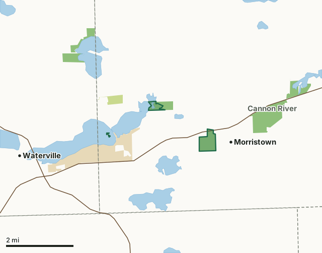
State wildlife management areasState forest and other DNR landState parksSakatah WMACounty lineLakeHighway
| Size | 212 acres in 4 pieces |
|---|---|
| County | Rice County |
| Deer Permit Area | DPA 232, DPA 292 |
| DNR lists for hunting | deer, wild turkey, pheasants, ducks and geese, ruffed grouse and other forest upland birds, mourning doves and small game |
| Nearest town (DNR) | Morristown |
| DNR area office | Owatonna |
| Nearest towns | Morristown (next to it), Waterville (3 mi) and Warsaw (4 mi) |
What is Sakatah WMA like?
The main unit of Sakatah Wildlife Management Area (WMA) is located near the outlet of Lower Sakatah Lake on the Cannon River. The WMA and adjacent Sakatah Aquatic Management Area (AMA) conserve a variety of riparian habitats along Lower Sakatah Lake and the Cannon River. Lowlands are dominated by marshes and willow swamps and woodlands. Upland habitats are mature forest, grasslands and brushland. The islands on the east end of Upper Sakatah Lake are a unique feature of Sakatah WMA providing critical breeding habitat for nesting colonial waterbirds including cormorants, great blue herons and great egrets. The primary management objective is to maintain island nesting habitat for colonial waterbirds and turtles and other species benefit from these special habitats. This disjunct unit of Sakatah Wildlife Management Area (WMA) is located near Morristown. The majority of the land has been planted to native grasslands. The unit is bisected by a chain of wetlands along small streams. Small woodlands are associated with riparian areas. The islands on the east end of Upper Sakatah Lake are a unique feature of this WMA providing critical breeding habitat for nesting colonial waterbirds including cormorants, great blue herons and great egrets.
Management focus for Sakatah WMA and AMA is conservation of diverse shallow lake and wetland habitats and riparian lands along the Upper Cannon River and associated chain of lakes. Habitat management may include efforts such as planting, prescribed burning, tree and brush cutting and conservation grazing to maintain a diversity of habitats attractive for wildlife. Forest management objectives are to maintain mature trees for species such as squirrels, wood ducks, woodpeckers and other wildlife that benefit from the forest cover and natural cavities. In recent years excessive growing season rainfalls have kept the islands partially to mostly submerged for substantial periods. The islands are suffering significant erosion damage from prolonged high water and excessive wave and wake action. They used to be one island.
In the DNR's words, from its wildlife management area data.
What can you hunt on Sakatah WMA?
The DNR's WMA data lists deer, wild turkey, pheasants, ducks and geese, ruffed grouse and other forest upland birds, mourning doves and small game for Sakatah WMA. Each follows the statewide season and, for deer, the bag limit of the permit area.
What are the rules on Sakatah WMA?
Open to hunting and trapping in the regular seasons under the DNR's statewide WMA rules.
How many deer are taken around Sakatah WMA?
Sakatah WMA lies in 2 deer permit areas. The DNR registered 745 deer in DPA 232 in 2025, against 773 in 2024.
| DPA | Sakatah WMA acres in it | Deer, 2025 | Deer, 2024 | Deer, 2023 |
|---|---|---|---|---|
| DPA 232 | 157 | 745 | 773 | 805 |
| DPA 292 | 56 | 1,197 | 1,149 | 1,088 |
Harvest for the whole deer permit area, not the WMA alone: Minnesota DNR Deer Harvest Reports (2021 to 2025, 2025 report).
How do you get to Sakatah WMA?
From Morristown go 0.75 miles W. on Hwy. 60, 1 mile W. on Co. Rd. 99, 0.5 miles N. on Judson Trail. The WMA address is 10951 245th Street West, Morristown. From Waterville go 2.2 miles E. on Hwy. 60, then 0.9 miles N. on LeRoy Avenue. The islands are in Upper Sakatah Lake about 800 feet west of the road grade. From Morristown take Franklin Street to the west edge of town. Alternatively, from the intersection of Iona Avenue (County Road 16) and Morristown Boulevard (Trunk Highway 60) at Morristown, travel west southwest about 0.5 miles to the intersection with 248th Street West. Travel southeast on 248th Street about 0.1 miles to the WMA. A parking area is on the south side of the street about 0.3 miles from the intersection of Highway 60 and 248th along the east boundary of the WMA. From Waterville go 2.2 miles E. on Hwy. 60,.then 0.9 miles N. on LeRoy Avenue. The islands are in Upper Sakatah Lake about 0.2 miles west of the road grade. There is a developed lake access in Sakatah State Park.
A parking area is located at the north end of Judson Trail at the Sakatah Aquatic Management Area, 10955 245th Street West, Morristown. The main portion of the WMA is about 0.1 miles west of the parking area and borders the west side of the Aquatic Management Area. Note the WMA and AMA do not provide land access to the Schmidke dam which is located on private land. A public boat launch and parking area at Sakatah State Park provides water access to Lower Sakatah Lake through Upper Sakatah Lake. A State Park Vehicle Pass is required to use this access. A developed boat access is provided at Sakatah State Park. Vehicle use permits are required to use this access and may be purchased at the Park headquarters. Off road parking is provided by a gravel-topped parking area located on the south side of 248th Street West/Franklin Street West, Morristown. A second gravel parking area is located on the east side of Jackson Avenue approximately 0.3 miles south of the intersection of Jackson Avenue and Trunk Highway 60 (Morristown Boulevard).
Nearest towns: Morristown (next to it), Waterville (3 miles), Warsaw (4 miles) and Kilkenny (6 miles). Highways within 5 miles: MN 60 and MN 13.
What other public land is near Sakatah WMA?
DNR WMAs within 10 miles:
- Cannon River WMA: 270 acres, 1.3 miles away
- Dwyer WMA: 56 acres, 4.8 miles away
- Murphy WMA: 212 acres, 5.3 miles away
- Pawek WMA: 79 acres, 5.4 miles away
- Diamond Lake WMA: 340 acres, 6.4 miles away
- Moonan WMA: 995 acres, 6.6 miles away
Public land within 3 miles of Sakatah WMA
Counting Sakatah WMA itself, 1,721 of the 34,350 acres within 3 miles of its boundary are public land open to the public (5%), by USGS PAD-US 4.1 (fee land open to the public).
| Manager | Acres within 3 miles |
|---|---|
| State wildlife management areas | 915 |
| State parks | 732 |
| State forest and other DNR land | 74 |
Questions hunters ask
Where is Sakatah WMA?
In Rice County, near Morristown. The DNR's directions: From Morristown go 0.75 miles W. on Hwy. 60, 1 mile W. on Co. Rd. 99, 0.5 miles N. on Judson Trail. The WMA address is 10951 245th Street West, Morristown. From Waterville go 2.2 miles E. on Hwy. 60, then 0.9 miles N. on LeRoy Avenue. The islands are in Upper Sakatah Lake about 800 feet west of the road grade. From Morristown take Franklin Street to the west edge of town. Alternatively, from the intersection of Iona Avenue (County Road 16) and Morristown Boulevard (Trunk Highway 60) at Morristown, travel west southwest about 0.5 miles to the intersection with 248th Street West. Travel southeast on 248th Street about 0.1 miles to the WMA. A parking area is on the south side of the street about 0.3 miles from the intersection of Highway 60 and 248th along the east boundary of the WMA. From Waterville go 2.2 miles E. on Hwy. 60,.then 0.9 miles N. on LeRoy Avenue. The islands are in Upper Sakatah Lake about 0.2 miles west of the road grade. There is a developed lake access in Sakatah State Park.
Which deer permit area is Sakatah WMA in?
DPA 232 (157 acres) and DPA 292 (56 acres). Each part follows its own permit area's bag limit.
How much public land is around Sakatah WMA?
1,721 acres within 3 miles of its boundary, Sakatah WMA included, by PAD-US 4.1. 6 other WMAs are within 10 miles, the closest Cannon River WMA (1.3 miles).
Get a Minnesota hunt plan when they open
Hunt plans for Minnesota are coming. Join the list and you'll hear first. The first 50 hunters in each new state get their plan free.
Until then, the free FilledTag app for iPhone has a map that works in every state, Minnesota included.
Where these facts come from
- Area description, species, rules and directions: DNR, Sakatah WMA; Minnesota DNR Wildlife Management Area boundaries, publicly accessible.
- Boundary and acres: the DNR's map layer above. Surrounding public land: USGS PAD-US 4.1 (fee land open to the public).
- Deer harvest: Minnesota DNR Deer Harvest Reports (2021 to 2025, 2025 report).
FilledTag is not part of the Minnesota Department of Natural Resources. Check the DNR's rules and posted signs before you go.