Pembina Wildlife Management Area: hunting and access
Pembina Wildlife Management Area is 6,671 acres of state land managed by the Minnesota DNR in Pennington, Polk and Red Lake counties, near Euclid, inside Deer Permit Area 256. The DNR's WMA data lists deer, wild turkey, ducks and geese, ruffed grouse and other forest upland birds, sharp-tailed grouse, bear and small game for it. Hunters registered 1,042 deer in DPA 256 in 2025.
Data updated October 2026. Area facts: the DNR's wildlife management area data, read 2026-10. Harvest: DNR Deer Harvest Reports, 2021 to 2025.
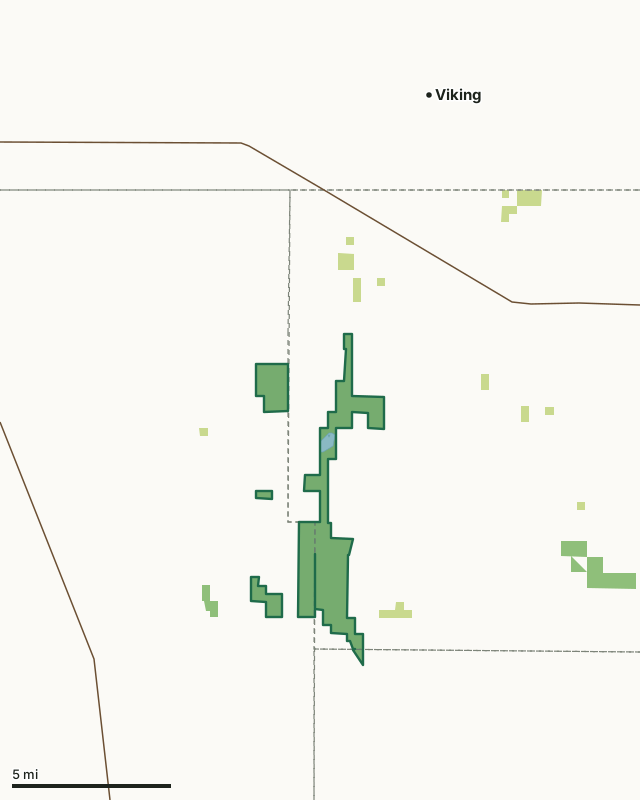
State wildlife management areasState forest and other DNR landPembina WMACounty lineLakeHighway
| Size | 6,671 acres in 4 pieces |
|---|---|
| Counties | Pennington County, Polk County and Red Lake County |
| Deer Permit Area | DPA 256 |
| DNR lists for hunting | deer, wild turkey, ducks and geese, ruffed grouse and other forest upland birds, sharp-tailed grouse, bear and small game |
| Nearest town (DNR) | Euclid |
| DNR area office | Thief River Falls |
| Nearest towns | Viking (8 mi), Red Lake Falls (10 mi) and St. Hilaire (11 mi) |
What is Pembina WMA like?
A large unit located in Polk and Pennington Counties It is characterized by open terrain that has wet prairie, sedge meadow, brush thickets, and scattered groves of aspen. Much of the grassland has been restored to native prairie. Over 4,000 acres in size, Pembina WMA consists of 2 beach ridges and an interbeach wetland complex that were formed when Glacial Lake Agassiz was receding. The topography is that of subtle ridges and swales that create a mosaic of habitat types from dry gravel prairies to wet meadows, and aspen/oak woodlands to lowland brush. Goose Lake, a natural 35-acre shallow lake basin, is located towards the north end of the WMA. Water drains to the south between the beach ridges and eventually out through an outlet structure at the southern end. Goose Lake and the associated marshes form the headwaters of the Little Black. The mix of habitat types brings with it a wide variety of game and non-game species. Wild turkeys have recently expanded into the WMA and have been seen in the spring and fall. The woodlots are used by ruffed grouse and woodcock, while the prairies and low brush provide habitat for both prairie chickens and sharp-tailed grouse. Deer are abundant and waterfowl utilize the marsh and numerous dugouts that were created years ago to provide open water. Sandhill cranes nest in the area and small groups are routinely seen in the fall.
This unit supports a diverse assemblage of both game and nongame wildlife. It is bisected by the historic Pembina Trail, which is usually accessible by vehicle during much of the year. The habitat management goals for the Pembina WMA are to maintain the diverse mix of habitat types. This includes using periodic prescribed fire and removal/regeneration of woody species by mowing and timber harvest. Currently, the DNR is attempting to reduce the non-native cattail invasion that has occurred over a large area of the Goose Lake Marsh. The goal is to reduce cattail cover, increase cover of native plants, and provide more open water. To achieve this goal, the DNR is trying a mix of water level management (via a stoplog control structure), herbicide treatments, prescribed burning, and possibly other techniques as more knowledge is gained about how to control this highly aggressive invader.
In the DNR's words, from its wildlife management area data.
What can you hunt on Pembina WMA?
The DNR's WMA data lists deer, wild turkey, ducks and geese, ruffed grouse and other forest upland birds, sharp-tailed grouse, bear and small game for Pembina WMA. Each follows the statewide season and, for deer, the bag limit of the permit area.
What are the rules on Pembina WMA?
Open to hunting and trapping in the regular seasons under the DNR's statewide WMA rules.
How many deer are taken around Pembina WMA?
Pembina WMA lies in Deer Permit Area 256. The DNR registered 1,042 deer in DPA 256 in 2025, against 1,033 in 2024.
| DPA | Pembina WMA acres in it | Deer, 2025 | Deer, 2024 | Deer, 2023 |
|---|---|---|---|---|
| DPA 256 | 6,671 | 1,042 | 1,033 | 867 |
Harvest for the whole deer permit area, not the WMA alone: Minnesota DNR Deer Harvest Reports (2021 to 2025, 2025 report).
How do you get to Pembina WMA?
From Euclid, go 3 miles N on a township road, then 6.5 miles E on County Road #21. From St. Hilaire, go 12 miles west on Center Ave W (County Rd 3) to main parking lot on south side of road.
The WMA is bisected by Center St. W (County Rd 3) and Pembina Trail NW/SW (County Rd 10), both paved roads. A parking lot is located on the south side of Center St. W. Where it passes through the WMA the Historic Pembina Trail route is a dirt track and not maintained, but it is generally accessible for much of the snow-free period by higher clearance vehicles (there are numerous potholes). A grass parking lot is located 1 mile north of Center St. W on the Historic Pembina Trail. Another grass parking lot is located along the historic trail south of Center St. W and is actually in Polk County. There are also several gravel township roads that allow access into portions of the WMA, as well as occasional pull-offs (field approaches) scattered throughout.
Nearest towns: Viking (8 miles), Red Lake Falls (10 miles), St. Hilaire (11 miles) and Thief River Falls (12 miles). Highways within 5 miles: MN 1.
What other public land is near Pembina WMA?
DNR WMAs within 10 miles:
- Belgium WMA: 190 acres, 1 mile away
- Moran WMA: 426 acres, 4.6 miles away
- Huot WMA: 424 acres, 5.6 miles away
- Higinbotham WMA: 984 acres, 6.5 miles away
- Stipa WMA: 161 acres, 9.4 miles away
Public land within 3 miles of Pembina WMA
Counting Pembina WMA itself, 7,482 of the 86,077 acres within 3 miles of its boundary are public land open to the public (8.7%), by USGS PAD-US 4.1 (fee land open to the public).
| Manager | Acres within 3 miles |
|---|---|
| State wildlife management areas | 6,861 |
| State forest and other DNR land | 621 |
Questions hunters ask
Where is Pembina WMA?
In Pennington, Polk and Red Lake counties, near Euclid. The DNR's directions: From Euclid, go 3 miles N on a township road, then 6.5 miles E on County Road #21. From St. Hilaire, go 12 miles west on Center Ave W (County Rd 3) to main parking lot on south side of road.
Which deer permit area is Pembina WMA in?
Deer Permit Area 256. Its bag limit and firearms dates apply.
How much public land is around Pembina WMA?
7,482 acres within 3 miles of its boundary, Pembina WMA included, by PAD-US 4.1. 5 other WMAs are within 10 miles, the closest Belgium WMA (1 mile).
Get a Minnesota hunt plan when they open
Hunt plans for Minnesota are coming. Join the list and you'll hear first. The first 50 hunters in each new state get their plan free.
Until then, the free FilledTag app for iPhone has a map that works in every state, Minnesota included.
Where these facts come from
- Area description, species, rules and directions: DNR, Pembina WMA; Minnesota DNR Wildlife Management Area boundaries, publicly accessible.
- Boundary and acres: the DNR's map layer above. Surrounding public land: USGS PAD-US 4.1 (fee land open to the public).
- Deer harvest: Minnesota DNR Deer Harvest Reports (2021 to 2025, 2025 report).
FilledTag is not part of the Minnesota Department of Natural Resources. Check the DNR's rules and posted signs before you go.
Minnesota hunting Pennington County Polk County Red Lake County DPA 256