Phelps Lake Wildlife Management Area: hunting and access
Phelps Lake Wildlife Management Area is 171 acres of state land managed by the Minnesota DNR in Rice County, near Lonsdale, inside Deer Permit Area 605. The DNR's WMA data lists deer, wild turkey, pheasants, ducks and geese, mourning doves and small game for it. Hunters registered 3,115 deer in DPA 605 in 2025.
Data updated October 2026. Area facts: the DNR's wildlife management area data, read 2026-10. Harvest: DNR Deer Harvest Reports, 2021 to 2025.
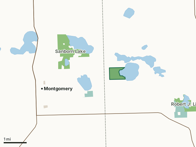
State wildlife management areasNational wildlife refuges and waterfowl production areasCounty, city and regional landPhelps Lake WMACounty lineLakeHighway
| Size | 171 acres |
|---|---|
| County | Rice County |
| Deer Permit Area | DPA 605 |
| DNR lists for hunting | deer, wild turkey, pheasants, ducks and geese, mourning doves and small game |
| Nearest town (DNR) | Lonsdale |
| DNR area office | Owatonna |
| Nearest towns | Montgomery (3 mi), Lonsdale (4 mi) and Heidelberg (6 mi) |
What is Phelps Lake WMA like?
This WMA is located along the west shore of Phelps Lake and the headwaters of Sand Creek. The area has rolling topography supporting a mix of grasslands, forest and extensive wetland habitats. Uplands north of Sand Creek are dominated by oak forest. A mixed-hardwood forest with ash, elm, boxelder, willows, maples and oaks is found along the shoreline of Phelps Lake.
Management emphasis for this area is on wetland and shoreline protection and continuing to maintain a mix of habitats for migratory and resident wildlife. Practices including habitat plantings, prescribed burns, and removal of invasive woody species will help maintain productive cover. Conservation of this area was made possible by the Outdoor Heritage Fund. The area provides opportunities for both enjoyment of wildlife and fishing. Bird watching is best during spring migration. Hunting opportunities are available for waterfowl and resident game including squirrels, cottontail rabbits, wild turkey, pheasants and deer. Muskrats, raccoons and other furbearers are common especially along the extensive marshlands adjacent to Sand Creek.
In the DNR's words, from its wildlife management area data.
What can you hunt on Phelps Lake WMA?
The DNR's WMA data lists deer, wild turkey, pheasants, ducks and geese, mourning doves and small game for Phelps Lake WMA. Each follows the statewide season and, for deer, the bag limit of the permit area.
What are the rules on Phelps Lake WMA?
Open to hunting and trapping in the regular seasons under the DNR's statewide WMA rules.
How many deer are taken around Phelps Lake WMA?
Phelps Lake WMA lies in Deer Permit Area 605. The DNR registered 3,115 deer in DPA 605 in 2025, against 2,826 in 2024.
| DPA | Phelps Lake WMA acres in it | Deer, 2025 | Deer, 2024 | Deer, 2023 |
|---|---|---|---|---|
| DPA 605 | 171 | 3,115 | 2,826 | 2,821 |
Harvest for the whole deer permit area, not the WMA alone: Minnesota DNR Deer Harvest Reports (2021 to 2025, 2025 report).
How do you get to Phelps Lake WMA?
From Lonsdale travel south about 3/4 miles south along County State Aid Highway 4 to Union Lake Trail (County 59). Travel 1.5 miles west along Union Lake Trail then south along Jasper Trail about 1/4 mile to Cody Lake Trail. Take Cody Lake Trail west about 2.4 miles to Lark Trail. The wildlife area is about 0.1 mile south of the intersection of Cody Lake and Lark Trails on the east side of Lark Trail.
There is a developed parking area on the east side of Lark Trail in the northwest corner of the Wildlife Area. Please respect our neighbors' private land. The wildlife area has shoreline along both Phelps Lake and Sand Creek but there is no vehicle access to the lake shore. A State Water Access at 11971 Cody Lake Trail provides a boat ramp and lake access to both Phelps and Cody Lakes.
Nearest towns: Montgomery (3 miles), Lonsdale (4 miles), Heidelberg (6 miles) and New Prague (7 miles). Highways within 5 miles: MN 21, MN 13, MN 99 and MN 19.
What other public land is near Phelps Lake WMA?
DNR WMAs within 10 miles:
- Sanborn Lake WMA: 549 acres, 1 mile away
- Robert J. Lick WMA: 194 acres, 2.3 miles away
- Big Woods Heritage Forest WMA: 127 acres, 4.4 miles away
- Gray Fox WMA: 76 acres, 5 miles away
- Boyd Sartell WMA: 1,367 acres, 5.2 miles away
- Dora Lake WMA: 742 acres, 6.6 miles away
Public land within 3 miles of Phelps Lake WMA
Counting Phelps Lake WMA itself, 1,054 of the 22,805 acres within 3 miles of its boundary are public land open to the public (4.6%), by USGS PAD-US 4.1 (fee land open to the public).
| Manager | Acres within 3 miles |
|---|---|
| State wildlife management areas | 840 |
| National wildlife refuges and waterfowl production areas | 203 |
| County, city and regional land | 11 |
Questions hunters ask
Where is Phelps Lake WMA?
In Rice County, near Lonsdale. The DNR's directions: From Lonsdale travel south about 3/4 miles south along County State Aid Highway 4 to Union Lake Trail (County 59). Travel 1.5 miles west along Union Lake Trail then south along Jasper Trail about 1/4 mile to Cody Lake Trail. Take Cody Lake Trail west about 2.4 miles to Lark Trail. The wildlife area is about 0.1 mile south of the intersection of Cody Lake and Lark Trails on the east side of Lark Trail.
Which deer permit area is Phelps Lake WMA in?
Deer Permit Area 605. Its bag limit and firearms dates apply.
How much public land is around Phelps Lake WMA?
1,054 acres within 3 miles of its boundary, Phelps Lake WMA included, by PAD-US 4.1. 6 other WMAs are within 10 miles, the closest Sanborn Lake WMA (1 mile).
Get a Minnesota hunt plan when they open
Hunt plans for Minnesota are coming. Join the list and you'll hear first. The first 50 hunters in each new state get their plan free.
Until then, the free FilledTag app for iPhone has a map that works in every state, Minnesota included.
Where these facts come from
- Area description, species, rules and directions: DNR, Phelps Lake WMA; Minnesota DNR Wildlife Management Area boundaries, publicly accessible.
- Boundary and acres: the DNR's map layer above. Surrounding public land: USGS PAD-US 4.1 (fee land open to the public).
- Deer harvest: Minnesota DNR Deer Harvest Reports (2021 to 2025, 2025 report).
FilledTag is not part of the Minnesota Department of Natural Resources. Check the DNR's rules and posted signs before you go.