Robert J. Lick Wildlife Management Area: hunting and access
Robert J. Lick Wildlife Management Area is 194 acres of state land managed by the Minnesota DNR in Rice County, near Lonsdale, inside Deer Permit Area 605. The DNR's WMA data lists deer, wild turkey, pheasants, ducks and geese and small game for it. Hunters registered 3,115 deer in DPA 605 in 2025.
Data updated October 2026. Area facts: the DNR's wildlife management area data, read 2026-10. Harvest: DNR Deer Harvest Reports, 2021 to 2025.
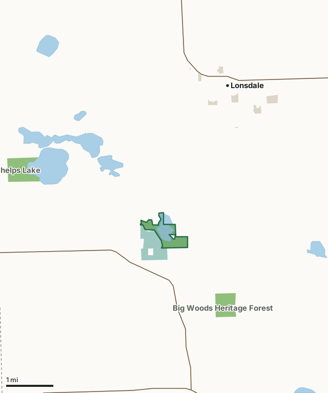
State wildlife management areasNational wildlife refuges and waterfowl production areasCounty, city and regional landRobert J. Lick WMACounty lineLakeHighway
| Size | 194 acres |
|---|---|
| County | Rice County |
| Deer Permit Area | DPA 605 |
| DNR lists for hunting | deer, wild turkey, pheasants, ducks and geese and small game |
| Nearest town (DNR) | Lonsdale |
| DNR area office | Owatonna |
| Nearest towns | Lonsdale (3 mi), Montgomery (6 mi) and Heidelberg (9 mi) |
What is Robert J. Lick WMA like?
The Logue Lake marshes are the dominant habitat feature of this WMA. Adjacent lands have rolling topography with a mixture upland and lowland forest, ponds and grass fields. Erin Prairie federal Waterfowl Production Area bounds the west side of the WMA.
Management emphasizes waterfowl habitat. The initial impetus for this wildlife area was centered around the restoration of Logue Lake which had been significantly impacted by attempts to drain the lake for farming. Through cooperation between local landowners, Rice County, the Minnesota Waterfowl Association and the Minnesota Department of Natural Resources, the project became a reality and the dam restoring the lake was the first project funded by revenues from the Minnesota Waterfowl Stamp. The wildlife area is named for Robert J. Lick an activist for wetland and waterfowl conservation in Minnesota. A newer dam and fish barrier have replaced that first structure continuing the private/public conservation efforts with Ducks Unlimited, the US Fish and Wildlife Service, Rice County and the MN Waterfowl Association assisting.
In the DNR's words, from its wildlife management area data.
What can you hunt on Robert J. Lick WMA?
The DNR's WMA data lists deer, wild turkey, pheasants, ducks and geese and small game for Robert J. Lick WMA. Each follows the statewide season and, for deer, the bag limit of the permit area.
What are the rules on Robert J. Lick WMA?
Open to hunting and trapping in the regular seasons under the DNR's statewide WMA rules.
How many deer are taken around Robert J. Lick WMA?
Robert J. Lick WMA lies in Deer Permit Area 605. The DNR registered 3,115 deer in DPA 605 in 2025, against 2,826 in 2024.
| DPA | Robert J. Lick WMA acres in it | Deer, 2025 | Deer, 2024 | Deer, 2023 |
|---|---|---|---|---|
| DPA 605 | 194 | 3,115 | 2,826 | 2,821 |
Harvest for the whole deer permit area, not the WMA alone: Minnesota DNR Deer Harvest Reports (2021 to 2025, 2025 report).
How do you get to Robert J. Lick WMA?
From Lonsdale go 3.2 miles S. on Co. Rd. 4, 11000 Independence Ave., Montgomery.
A small grass surface parking area is located on the north side of the trail near the south east corner of the wildlife area. There is a primitive cartway to a second parking area and carry-down boat access located adjacent to the lake and dam site. The path to the boat access can be slippery in adverse weather. Visitors are encouraged to use the upper parking area unless planning to launch a watercraft.
Nearest towns: Lonsdale (3 miles), Montgomery (6 miles), Heidelberg (9 miles) and New Prague (9 miles). Highways within 5 miles: MN 21, MN 19 and MN 99.
What other public land is near Robert J. Lick WMA?
DNR WMAs within 10 miles:
- Big Woods Heritage Forest WMA: 127 acres, 1.1 miles away
- Phelps Lake WMA: 171 acres, 2.3 miles away
- Boyd Sartell WMA: 1,367 acres, 3.5 miles away
- Circle Lake WMA: 263 acres, 4 miles away
- Gray Fox WMA: 76 acres, 4.1 miles away
- Sanborn Lake WMA: 549 acres, 4.1 miles away
Public land within 3 miles of Robert J. Lick WMA
Counting Robert J. Lick WMA itself, 690 of the 23,714 acres within 3 miles of its boundary are public land open to the public (2.9%), by USGS PAD-US 4.1 (fee land open to the public).
| Manager | Acres within 3 miles |
|---|---|
| State wildlife management areas | 475 |
| National wildlife refuges and waterfowl production areas | 172 |
| County, city and regional land | 43 |
Questions hunters ask
Where is Robert J. Lick WMA?
In Rice County, near Lonsdale. The DNR's directions: From Lonsdale go 3.2 miles S. on Co. Rd. 4, 11000 Independence Ave., Montgomery.
Which deer permit area is Robert J. Lick WMA in?
Deer Permit Area 605. Its bag limit and firearms dates apply.
How much public land is around Robert J. Lick WMA?
690 acres within 3 miles of its boundary, Robert J. Lick WMA included, by PAD-US 4.1. 6 other WMAs are within 10 miles, the closest Big Woods Heritage Forest WMA (1.1 miles).
Get a Minnesota hunt plan when they open
Hunt plans for Minnesota are coming. Join the list and you'll hear first. The first 50 hunters in each new state get their plan free.
Until then, the free FilledTag app for iPhone has a map that works in every state, Minnesota included.
Where these facts come from
- Area description, species, rules and directions: DNR, Robert J. Lick WMA; Minnesota DNR Wildlife Management Area boundaries, publicly accessible.
- Boundary and acres: the DNR's map layer above. Surrounding public land: USGS PAD-US 4.1 (fee land open to the public).
- Deer harvest: Minnesota DNR Deer Harvest Reports (2021 to 2025, 2025 report).
FilledTag is not part of the Minnesota Department of Natural Resources. Check the DNR's rules and posted signs before you go.