Red Lake Wildlife Management Area: hunting and access
Red Lake Wildlife Management Area is 322,335 acres of state land managed by the Minnesota DNR in Beltrami, Lake of the Woods and Koochiching counties, near Roosevelt, inside Deer Permit Areas 111, 104 and 101. The DNR's WMA data lists deer, ducks and geese, ruffed grouse and other forest upland birds, sharp-tailed grouse, bear and small game for it. Hunters registered 412 deer in DPA 111 in 2025.
Data updated October 2026. Area facts: the DNR's wildlife management area data, read 2026-10. Harvest: DNR Deer Harvest Reports, 2021 to 2025.
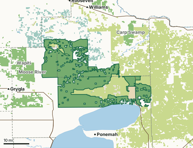
State wildlife management areasState forest and other DNR landNational wildlife refuges and waterfowl production areasState parksLand trusts and other open landRed Lake WMACounty lineLakeHighway
| Size | 322,335 acres in 18 pieces |
|---|---|
| Counties | Beltrami County, Lake of the Woods County and Koochiching County |
| Deer Permit Area | DPA 111, DPA 104, DPA 101 |
| DNR lists for hunting | deer, ducks and geese, ruffed grouse and other forest upland birds, sharp-tailed grouse, bear and small game |
| Nearest town (DNR) | Roosevelt |
| DNR area office | Red Lake WMA |
| Special restrictions | Yes, see the rules below |
| Nearest towns | Ponemah (11 mi), Williams (13 mi) and Grygla (14 mi) |
What is Red Lake WMA like?
This WMA is the largest in the state. It's located within the Beltrami Island State Forest and is composed of ancient glacial Lake Agassiz beach ridges of upland forest surrounded by extensive wetlands of open bog, brushlands, and lowland forest. This subunit of the Red Lake WMA is managed by the Baudette Area Wildlife staff. Red Lake WMA is the largest in the state and is located within the Beltrami Island State Forest. It is composed of ancient, glacial Lake Agassiz beach ridges of upland forest surrounded by extensive wetlands of open bog, brushlands, and lowland forest.
The Red Lake WMA headquarters, Norris Camp, is an old CCC camp that is on the National List of Historic Places. This WMA is a good place for grouse, deer, and woodcock hunting. Bird watchers come from all over the country looking for species such as the spruce grouse, black-backed woodpeckers, and Connecticut warblers. Berry picking opportunities include blueberries, juneberries, chokecherries, high bush cranberries, and other wild berries. A watershed protection area surrounding the Red Lake SNA overlaps the southern portion of the WMA. There are 25 forest hunter walking trails. These trails are mowed and maps are located at each trail head. This large WMA provides opportunity to view and/or hunt a wide variety of species. Moose, wolves and deer inhabit portions of this WMA, though access for viewing may be difficult.
In the DNR's words, from its wildlife management area data.
What can you hunt on Red Lake WMA?
The DNR's WMA data lists deer, ducks and geese, ruffed grouse and other forest upland birds, sharp-tailed grouse, bear and small game for Red Lake WMA. Each follows the statewide season and, for deer, the bag limit of the permit area.
What are the rules on Red Lake WMA?
Open to hunting and trapping in the regular seasons under the DNR's statewide WMA rules.
Special restriction the DNR lists for Red Lake WMA: Trapping is allowed on Red Lake WMA but some special restrictions apply and a permit is required. You can contact us at the above links for a free permit.
Red Lake WMA is one of the WMAs where every trapper needs a permit from the area wildlife manager.
Highway-licensed vehicles may drive the established roads on Red Lake WMA; on most WMAs vehicles are kept to designated routes.
How many deer are taken around Red Lake WMA?
Red Lake WMA lies in 3 deer permit areas. The DNR registered 412 deer in DPA 111 in 2025, against 370 in 2024.
| DPA | Red Lake WMA acres in it | Deer, 2025 | Deer, 2024 | Deer, 2023 |
|---|---|---|---|---|
| DPA 111 | 297,406 | 412 | 370 | 318 |
| DPA 104 | 24,863 | 450 | 445 | 354 |
| DPA 101 | 15 | 759 | 688 | 594 |
Harvest for the whole deer permit area, not the WMA alone: Minnesota DNR Deer Harvest Reports (2021 to 2025, 2025 report).
How do you get to Red Lake WMA?
From Roosevelt, go 1.7 miles SW on Co 142, then 13 miles south on the Norris-Roosevelt State Forest Road, then 2 miles west on Faunce Butterfield Road to the RLWMA headquarters at Norris Camp. From Waskish, go 5 miles N on Hwy 72.
The ground is often wet in many parts of this unit, thus access may be difficult in some areas.
Nearest towns: Ponemah (11 miles), Williams (13 miles), Grygla (14 miles) and Roosevelt (15 miles). Highways within 5 miles: MN 72 and MN 89.
What other public land is near Red Lake WMA?
DNR WMAs within 10 miles:
- Steenerson WMA: 159 acres, 2.5 miles away
- Moose River WMA: 21,275 acres, 2.9 miles away
- Rako WMA: 400 acres, 3.6 miles away
- North Rapid River WMA: 78 acres, 5.3 miles away
- Hamre WMA: 4,530 acres, 6 miles away
- Wapiti WMA: 31,755 acres, 6 miles away
Public land within 3 miles of Red Lake WMA
Counting Red Lake WMA itself, 489,711 of the 731,900 acres within 3 miles of its boundary are public land open to the public (66.9%), by USGS PAD-US 4.1 (fee land open to the public).
| Manager | Acres within 3 miles |
|---|---|
| State wildlife management areas | 322,541 |
| State forest and other DNR land | 130,808 |
| National wildlife refuges and waterfowl production areas | 22,598 |
| State parks | 9,105 |
| Land trusts and other open land | 4,659 |
Questions hunters ask
Where is Red Lake WMA?
In Beltrami, Lake of the Woods and Koochiching counties, near Roosevelt. The DNR's directions: From Roosevelt, go 1.7 miles SW on Co 142, then 13 miles south on the Norris-Roosevelt State Forest Road, then 2 miles west on Faunce Butterfield Road to the RLWMA headquarters at Norris Camp. From Waskish, go 5 miles N on Hwy 72.
Which deer permit area is Red Lake WMA in?
DPA 111 (297,406 acres), DPA 104 (24,863 acres) and DPA 101 (15 acres). Each part follows its own permit area's bag limit.
How much public land is around Red Lake WMA?
489,711 acres within 3 miles of its boundary, Red Lake WMA included, by PAD-US 4.1. 6 other WMAs are within 10 miles, the closest Steenerson WMA (2.5 miles).
Get a Minnesota hunt plan when they open
Hunt plans for Minnesota are coming. Join the list and you'll hear first. The first 50 hunters in each new state get their plan free.
Until then, the free FilledTag app for iPhone has a map that works in every state, Minnesota included.
Where these facts come from
- Area description, species, rules and directions: DNR, Red Lake WMA; Minnesota DNR Wildlife Management Area boundaries, publicly accessible.
- Boundary and acres: the DNR's map layer above. Surrounding public land: USGS PAD-US 4.1 (fee land open to the public).
- Deer harvest: Minnesota DNR Deer Harvest Reports (2021 to 2025, 2025 report).
FilledTag is not part of the Minnesota Department of Natural Resources. Check the DNR's rules and posted signs before you go.
Minnesota hunting Beltrami County Lake of the Woods County Koochiching County DPA 111 DPA 104 DPA 101