Deer Permit Area 111: deer harvest, seasons and public land
Minnesota's Deer Permit Area 111 covers 1,386 square miles of Lake of the Woods, Beltrami and Roseau counties, near Roosevelt. Hunters registered 412 deer here in 2025, 403 of them adult bucks, by the DNR's 2025 Deer Harvest Report. That is up 11% from 2024, and the most in the 5 years shown. 59.7% of DPA 111 is public land open to the public, the largest share state wildlife management areas (325,810 acres), by USGS PAD-US 4.1 (fee land open to the public).
Data updated October 2026. Harvest: DNR Deer Harvest Reports, 2021 to 2025. Seasons: the DNR's 2026 deer permit area map. Land: PAD-US 4.1, DNR WMA and Walk-In Access layers.
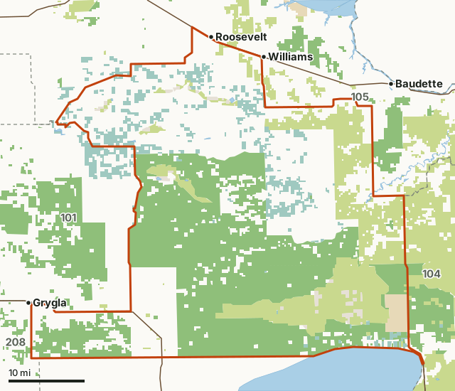
State wildlife management areasState forest and other DNR landNational wildlife refuges and waterfowl production areasState parksLand trusts and other open landDPA 111Neighboring deer permit areasLakeHighway
| Counties | Lake of the Woods County, Beltrami County, Roseau County and Marshall County |
|---|---|
| Size | 887,153 acres (1,386 square miles) |
| 2026 bag limit | One-deer limit: antlerless permit lottery (25) |
| Firearm A season, 2026 | Nov. 7 to Nov. 22, 2026 |
| Deer registered, 2025 | 412 (403 adult bucks) |
| Firearms hunters, 2025 | 1,405 |
| Public land | 59.7% (529,501 acres) |
| WMAs | 15 (325,772 acres inside DPA 111) |
| Walk-In Access | None mapped this year |
| Towns in and near it | Roosevelt, Williams and Grygla |
How many deer are harvested in DPA 111?
The DNR registered 412 deer in DPA 111 in 2025: 403 adult bucks, 7 adult does and 2 fawns, about 0.3 deer for each of the 1,384 square miles of land the DNR counts in it. 1,405 hunters used their firearms license here in the A season and registered 382 deer, about 27 deer for every 100 of them. Archers: 64 hunters, 6 deer.
| Year | Deer registered | Adult bucks | Adult does | Fawns | Deer per square mile | Firearms hunters | Firearms harvest | Archery hunters | Archery harvest | Muzzleloader hunters | Muzzleloader harvest |
|---|---|---|---|---|---|---|---|---|---|---|---|
| 2025 | 412 | 403 | 7 | 2 | 0.30 | 1,405 | 382 | 64 | 6 | 58 | 3 |
| 2024 | 370 | 364 | 6 | 0 | 0.27 | 1,200 | 345 | 80 | 7 | 37 | 3 |
| 2023 | 318 | 311 | 6 | 1 | 0.23 | 1,169 | 304 | 80 | 5 | 56 | 2 |
| 2022 | 290 | 281 | 8 | 1 | 0.21 | 1,204 | 269 | 80 | 4 | 31 | 6 |
| 2021 | 406 | 390 | 14 | 2 | 0.29 | 1,330 | 377 | 97 | 6 | 53 | 7 |
Source: Minnesota DNR Deer Harvest Reports, 2025, 2024, 2023, 2022 and 2021: Table 3 (all deer, special hunts left out), Tables 4 to 6 (archery, firearms A season, muzzleloader). Deer per square mile is the DNR's total divided by the DNR's land area for the permit area. A blank means the DNR printed no row for DPA 111 that year.
When are the 2026 deer seasons in DPA 111?
DPA 111 is a "One-deer limit: antlerless permit lottery (25)" area for 2026. It is in the 100 series, which sets its firearms dates. Firearm A season: Nov. 7 to Nov. 22, 2026.
| Season | 2026 dates or rule |
|---|---|
| Bag limit designation | One-deer limit: antlerless permit lottery (25) |
| Archery | Sept. 19 to Dec. 31, 2026 |
| Firearm A season | Nov. 7 to Nov. 22, 2026 |
| Muzzleloader | Nov. 28 to Dec. 13, 2026 |
| Youth season | Oct. 15 to Oct. 18, 2026 |
| CWD testing | Optional CWD testing available |
Source: Minnesota DNR deer permit areas, 2026 seasons (July 2026 - June 2027). Special regulations for WMAs in this permit area. Details are on the DNR's WMA rules page. Check the DNR's regulations before you go: dates and limits can change during the year.
How much public land is in DPA 111?
529,501 of DPA 111's 887,153 acres are public land open to the public (59.7%). The biggest share is state wildlife management areas: 325,810 acres.
| Manager | Acres | Share of DPA 111 |
|---|---|---|
| State wildlife management areas | 325,810 | 36.7% |
| State forest and other DNR land | 137,384 | 15.5% |
| National wildlife refuges and waterfowl production areas | 49,918 | 5.6% |
| State parks | 8,979 | 1% |
| Land trusts and other open land | 7,410 | 0.8% |
| All public land open to the public | 529,501 | 59.7% |
Measured by FilledTag inside the DNR's boundary from USGS PAD-US 4.1 (fee land open to the public). Hunting rules differ by manager: state wildlife management areas, state forest land and national forests are open to hunting in season; refuges and waterfowl production areas follow U.S. Fish and Wildlife Service rules; state parks allow hunting only in special hunts; national park land is closed to hunting; city and county parks set their own rules. PAD-US 4.1 leaves out most of the tax-forfeited land Minnesota counties manage, much of it open to hunting, so the public land here may be more than shown; the county land department has the maps.
Wildlife Management Areas in DPA 111
DNR WMAs in DPA 111, largest first, with the acres of each inside it:
- Red Lake WMA: 297,406 acres
- Wolf Trail WMA: 7,792 acres
- Hamre WMA: 4,530 acres
- Carmelee WMA: 3,905 acres
- Willow-Run WMA: 3,564 acres
- Fireweed WMA: 2,266 acres
- Lee WMA: 2,245 acres
- Gun-dog WMA: 1,354 acres
- Saw-whet WMA: 1,286 acres
- Sem WMA: 622 acres
- Rako WMA: 400 acres
- Steenerson WMA: 159 acres
- Espelie WMA: 159 acres
- North Rapid River WMA: 78 acres
- Carp Swamp WMA: 6 acres
Other large public areas here, by PAD-US: Beltrami Wildlife Management Area (71,229 acres), Lake of the Woods State Forest (65,465 acres) and Big Bog (8,997 acres).
How do you get to DPA 111?
Highways through it: MN 89 (about 12 miles inside), MN 72 (about 8 miles inside) and MN 11 (about 6 miles inside). Nearby: Roosevelt (on the line), Williams (on the line), Grygla (on the line) and Baudette (4 miles).
Which deer permit areas border DPA 111?
DPA 111 touches 5 other deer permit areas. Their latest DNR harvest and public land, for comparison:
| DPA | Deer harvested | Year | Public land | Walk-In Access sites |
|---|---|---|---|---|
| DPA 101 | 759 | 2025 | 29.6% | |
| DPA 104 | 450 | 2025 | 74.7% | |
| DPA 105 | 2,485 | 2025 | 26.1% | |
| DPA 110 | 1,210 | 2025 | 23.8% | |
| DPA 208 | 465 | 2025 | 3.8% |
Questions hunters ask
How many deer were harvested in DPA 111 in 2025?
412 deer were registered: 403 adult bucks, 7 adult does and 2 fawns (DNR 2025 Deer Harvest Report, Table 3). The most in the 5 years shown was 412, in 2025.
What is the 2026 bag limit in DPA 111?
The DNR lists DPA 111 as "One-deer limit: antlerless permit lottery (25)" for 2026. Firearm A season: Nov. 7 to Nov. 22, 2026.
Is there public land to hunt in DPA 111?
Yes. 529,501 acres, 59.7% of the permit area, are public land open to the public by PAD-US 4.1, mostly state wildlife management areas. The DNR's map shows 15 wildlife management areas here, the largest Red Lake WMA (297,406 acres).
How many firearms hunters hunt DPA 111?
1,405 in the 2025 firearms A season, by the DNR's Table 5. They registered 382 deer, 376 of them adult bucks.
Get a Minnesota hunt plan when they open
Hunt plans for Minnesota are coming. Join the list and you'll hear first. The first 50 hunters in each new state get their plan free.
Until then, the free FilledTag app for iPhone has a map that works in every state, Minnesota included.
Where these numbers come from
- Deer harvest: Minnesota DNR Deer Harvest Reports (2021 to 2025, 2025 report).
- Seasons: Minnesota DNR deer permit areas, 2026 seasons; DNR season calendar.
- Public land: USGS PAD-US 4.1 (fee land open to the public). Wildlife Management Areas: Minnesota DNR Wildlife Management Area boundaries, publicly accessible. Walk-In Access: Minnesota DNR Walk-In Access sites.
- Boundaries: Minnesota DNR deer permit areas, 2026 seasons. Highways and towns: U.S. Census Bureau TIGER/Line 2024 primary and secondary roads; U.S. Census Bureau 2024 Gazetteer, places.
FilledTag is not part of the Minnesota Department of Natural Resources. Numbers are copied from the DNR and the federal sources above, or measured from their maps; nothing on this page is estimated by FilledTag.
Minnesota hunting Lake of the Woods County Beltrami County Roseau County Marshall County DPA 101 DPA 104 DPA 105 DPA 110 DPA 208