Wolf Trail Wildlife Management Area: hunting and access
Wolf Trail Wildlife Management Area is 7,792 acres of state land managed by the Minnesota DNR in Beltrami County, near Grygla, inside Deer Permit Area 111. The DNR's WMA data lists deer, ruffed grouse and other forest upland birds, sharp-tailed grouse, bear and small game for it. Hunters registered 412 deer in DPA 111 in 2025.
Data updated October 2026. Area facts: the DNR's wildlife management area data, read 2026-10. Harvest: DNR Deer Harvest Reports, 2021 to 2025.
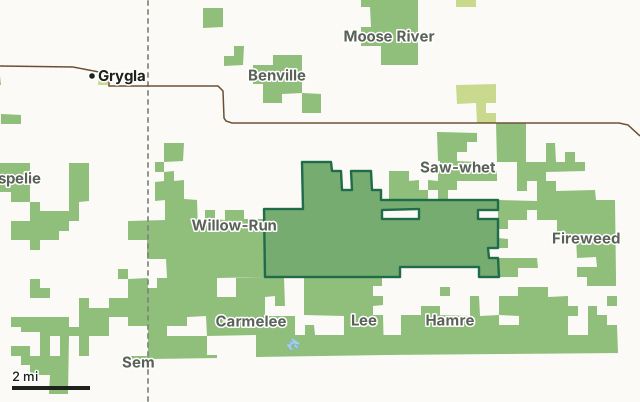
State wildlife management areasState forest and other DNR landWolf Trail WMACounty lineLakeHighway
| Size | 7,792 acres |
|---|---|
| County | Beltrami County |
| Deer Permit Area | DPA 111 |
| DNR lists for hunting | deer, ruffed grouse and other forest upland birds, sharp-tailed grouse, bear and small game |
| Nearest town (DNR) | Grygla |
| DNR area office | Thief River Falls |
| Nearest towns | Grygla (6 mi), Goodridge (14 mi) and Ponemah (27 mi) |
What is Wolf Trail WMA like?
The nearly 8,00 acre Wolf Trail WMA, along with several other nearby WMAs, forms a large block of habitat and public recreation opportunities. The area has generally flat topography and poorly drained soils. Historically much of Willow-Run and Wolf Trail WMAs was a large open meadow with scattered brush and aspen groves, and occasional spruce and tamarac trees. Tree cover was more extensive around the edge of the open meadow. These areas are currently encompassed by the WMAs that surround Willow-Run and Wolf Trail (Carmelee, Lee, Hamre, Fireweed, Gundog and Saw-whet WMAs). In an effort to drain the land for farming and other development, an extensive network of ditches were dug in the early part of the 20th century. Drainage was largely unsuccessful in the areas now encompassed by the WMAs and eventually came under State management due to tax forfeiture. Today the land cover on Willow Run and Wolf Trail is a mix of sedge meadows, lowland brush and aspen/oak woodlands. Spruce and tamarac are more rare, possibly due to the drainage ditches that still exist. Game species that utilize this area include deer, bear, sandhill crane, ruffed grouse, sharp-tailed grouse, woodcock and numerous furbearers. A wide variety of non-game species are also present and provide many opportunities for bird-watching and wildlife viewing. Because of the nature of the soils and topography in this area, knee boots or hip waders are highly recommended throughout the year.
Management goals for Willow-Run and Wolf Trail WMAs include maintaining an open mix of grass and brush for sharp-tailed grouse, and young forest for deer, ruffed grouse, and woodcock. These habitats are maintained by a combination of prescribed fire and shearing/mowing. Where soils allow the development of more mature and commercially viable timber, longer rotation timber harvests are anticipated. Wolves are known to occur in the area in and around Wolf Trail WMA and there have been reports of elk sightings. A portion of the Fourtown-Grygla ATV trail runs through the WMA. This trail is not open year round, check the DNR website for open/closure postings. A maintained snowmobile trail also cuts through the WMA (the Fourtown-Grygla Snowmobile trail).
In the DNR's words, from its wildlife management area data.
What can you hunt on Wolf Trail WMA?
The DNR's WMA data lists deer, ruffed grouse and other forest upland birds, sharp-tailed grouse, bear and small game for Wolf Trail WMA. Each follows the statewide season and, for deer, the bag limit of the permit area.
What are the rules on Wolf Trail WMA?
Open to hunting and trapping in the regular seasons under the DNR's statewide WMA rules.
How many deer are taken around Wolf Trail WMA?
Wolf Trail WMA lies in Deer Permit Area 111. The DNR registered 412 deer in DPA 111 in 2025, against 370 in 2024.
| DPA | Wolf Trail WMA acres in it | Deer, 2025 | Deer, 2024 | Deer, 2023 |
|---|---|---|---|---|
| DPA 111 | 7,792 | 412 | 370 | 318 |
Harvest for the whole deer permit area, not the WMA alone: Minnesota DNR Deer Harvest Reports (2021 to 2025, 2025 report).
How do you get to Wolf Trail WMA?
From Grygla, go 10.5 miles E on MN 89, then 3 miles S on Jelle Rd to the campground entrance on the west side of the road.
Several gravel roads bisect or border the WMA. These roads may not have shoulders or soft shoulders so use caution. A few pull-offs (field approaches) are available. A primitive campground consisting of a mowed opening is available on the west side of Jelle Rd. A portion of the Fourtown-Grygla ATV trail cuts through the WMA and is generally open from June 1st to October 31st, but consult the DNR website for open/closure postings. ATVs are also allowed under limited conditions to retrieve known downed deer during the hunting season. Consult the DNR regulations for more information. A portion of the maintained Fourtown-Grygla snowmobile trail cuts through the WMA and snowmobiles are allowed throughout the WMA according to State regulations.
Nearest towns: Grygla (6 miles), Goodridge (14 miles), Ponemah (27 miles) and Little Rock (28 miles). Highways within 5 miles: MN 89.
What other public land is near Wolf Trail WMA?
DNR WMAs within 10 miles:
- Carmelee WMA: 3,907 acres, next to it
- Lee WMA: 2,245 acres, next to it
- Fireweed WMA: 2,266 acres, next to it
- Willow-Run WMA: 3,564 acres, next to it
- Saw-whet WMA: 1,286 acres, next to it
- Hamre WMA: 4,530 acres, 0.5 miles away
Public land within 3 miles of Wolf Trail WMA
Counting Wolf Trail WMA itself, 27,729 of the 58,879 acres within 3 miles of its boundary are public land open to the public (47.1%), by USGS PAD-US 4.1 (fee land open to the public).
| Manager | Acres within 3 miles |
|---|---|
| State wildlife management areas | 27,285 |
| State forest and other DNR land | 444 |
Questions hunters ask
Where is Wolf Trail WMA?
In Beltrami County, near Grygla. The DNR's directions: From Grygla, go 10.5 miles E on MN 89, then 3 miles S on Jelle Rd to the campground entrance on the west side of the road.
Which deer permit area is Wolf Trail WMA in?
Deer Permit Area 111. Its bag limit and firearms dates apply.
How much public land is around Wolf Trail WMA?
27,729 acres within 3 miles of its boundary, Wolf Trail WMA included, by PAD-US 4.1. 6 other WMAs are within 10 miles, the closest Carmelee WMA (next to it).
Get a Minnesota hunt plan when they open
Hunt plans for Minnesota are coming. Join the list and you'll hear first. The first 50 hunters in each new state get their plan free.
Until then, the free FilledTag app for iPhone has a map that works in every state, Minnesota included.
Where these facts come from
- Area description, species, rules and directions: DNR, Wolf Trail WMA; Minnesota DNR Wildlife Management Area boundaries, publicly accessible.
- Boundary and acres: the DNR's map layer above. Surrounding public land: USGS PAD-US 4.1 (fee land open to the public).
- Deer harvest: Minnesota DNR Deer Harvest Reports (2021 to 2025, 2025 report).
FilledTag is not part of the Minnesota Department of Natural Resources. Check the DNR's rules and posted signs before you go.